Country:
 Mexico
Region:
City:
Latitude and Longitude:
Time Zone:
Postal Code:
IP information under different IP Channel
ip-api
Country
Region
City
ASN
Time Zone
ISP
Blacklist
Proxy
Latitude
Longitude
Postal
Route
IPinfo
Country
Region
City
ASN
Time Zone
ISP
Blacklist
Proxy
Latitude
Longitude
Postal
Route
MaxMind
Country
Region
City
ASN
Time Zone
ISP
Blacklist
Proxy
Latitude
Longitude
Postal
Route
Luminati
Country
MXRegion
cmx
City
mexicocity
ASN
Time Zone
America/Mexico_City
ISP
LLC ott Ukraine
Latitude
Longitude
Postal
db-ip
Country
Region
City
ASN
Time Zone
ISP
Blacklist
Proxy
Latitude
Longitude
Postal
Route
ipdata
Country
Region
City
ASN
Time Zone
ISP
Blacklist
Proxy
Latitude
Longitude
Postal
Route
Popular places and events near this IP address

History of Mexico City
Distance: Approx. 527 meters
Latitude and longitude: 19.43308611,-99.12884444
The history of Mexico City stretches back to its founding ca. 1325 CE as the Mexica city-state of Tenochtitlan, which evolved into the senior partner of the Aztec Triple Alliance that dominated central Mexico immediately prior to the Spanish conquest of 1519–1521. At its height, Tenochtitlan had enormous temples and palaces, a huge ceremonial center, and residences of political, religious, military, and merchants.
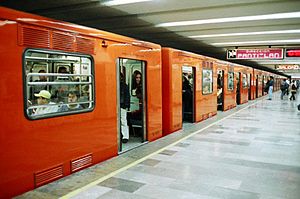
Merced metro station
Mexico City metro station
Distance: Approx. 452 meters
Latitude and longitude: 19.425558,-99.124639
Merced is an underground station on Line 1 of the Mexico City Metro. It is located in the Venustiano Carranza borough, slightly to the east of the centre of Mexico City. The station building was designed by Félix Candela, and it was opened on 4 September 1969.

Faculty of Arts and Design
Art school of the Universidad Nacional Autónoma de México
Distance: Approx. 525 meters
Latitude and longitude: 19.43305556,-99.12888889
The Faculty of Arts and Design (Spanish: Facultad de Artes y Diseño ; formerly known as the Escuela Nacional de Artes Plásticas or ENAP), is a college of art in Xochimilco, Mexico City. The school is part the Universidad Nacional Autónoma de México, and is responsible for teaching painting, sculpture and graphic design, with undergraduate and graduate studies in San Carlos. In 2007 and 2008, the Council of Designers of Mexico recognised the faculty as the best art school in Mexico.

Academy of San Carlos
Located in Mexico City, it was the first major art academy and the first art museum in the Americas
Distance: Approx. 527 meters
Latitude and longitude: 19.43308611,-99.12884444
The Academy of San Carlos (Spanish: Academia de San Carlos) is located at 22 Academia Street in just northeast of the main plaza of Mexico City. It was the first major art academy and the first art museum in the Americas. It was founded in 1781 as the School of Engraving and moved to the Academia Street location about 10 years later.

La Santísima Church
Church in Mexico City, Mexico
Distance: Approx. 524 meters
Latitude and longitude: 19.43315833,-99.12686111
La Santísima Church is located 12 La Santísima Street at corner of Emiliano Zapata Street in the historic center of Mexico City. Its full name is Church and Hospital of the Most Holy Trinity (Templo y Antiguo Hospital de la Santisíma Trinidad) . The church was built between 1755 and 1783 as a temple for the adjoining hospital/hospice for priests.

Convent of La Merced, Mexico City
Distance: Approx. 112 meters
Latitude and longitude: 19.42948333,-99.12783611
The Convent of Nuestra Señora de La Merced was a Roman Catholic colonial religious complex in present-day Historic center of Mexico City, that was destroyed to give more space to future buildings. The cloister is all that is left of a monastery complex built in the late 16th and early 17th century by the Mercedarian order. It is located on Uruguay and Talavera Streets in the historic downtown of Mexico City.

Museum of Mexico City
Art museum in Mexico
Distance: Approx. 525 meters
Latitude and longitude: 19.4292,-99.13254722
The Museum of Mexico City (Museo de la Ciudad de Mexico) is located at Pino Suarez 30, a few blocks south of the Zocalo, on what was the Iztapalapa Causeway, near where Hernán Cortés and Moctezuma II met for the first time. This building used to be the palace of the Counts of Santiago de Calimaya, who were the descendants of one of the conquistadors with Cortés. The house was extensively remodeled during the colony to much the appearance that it has today and remained in the family until 1960, when the Mexico City government acquired it from them in order to found the Museum that is found there today.

Valvanera Cathedral, Mexico City
Church in Mexico
Distance: Approx. 314 meters
Latitude and longitude: 19.42940833,-99.13043333
The Cathedral of Our Lady of Valvanera (also Maronite Cathedral of Our Lady of Valvanera sometimes spelled Balvanera, Spanish: Catedral Maronita de Nuestra Señora de Valvanera) is located southeast of the main plaza, or Zocalo, of Mexico City on the corner of Correo Mayor and República de Uruguay in the historic center. The church originally belonged to the Convent of Santo Niño Perdido which was founded in 1573. This would then become a Conceptionist convent in the 17th century, when the church and convent were rebuilt in 1667.

La Merced Market
Distance: Approx. 470 meters
Latitude and longitude: 19.42592222,-99.12405833
The La Merced Market is a traditional public market located in the eastern edge of the historic center of Mexico City and is the largest retail traditional food market in the entire city. The area, also called La Merced, has been synonymous with commercial activity since the early colonial period when traders arrived here from other parts of New Spain. At one time, nearly the entire neighborhood was filled with market stalls and in the 1860s it was decided to build a permanent market on the grounds of the old La Merced monastery.
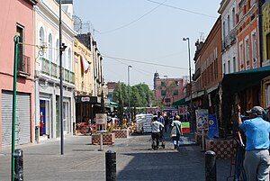
La Merced (neighborhood)
Human settlement in Mexico
Distance: Approx. 301 meters
Latitude and longitude: 19.42673333,-99.12543333
La Merced is a barrio or a neighborhood of Mexico City defined by its socioeconomics and history rather than by an official designation. It extends over the southeast of the historic center of Mexico City and is one of the oldest sections of the city, established over 700 years ago by the Mexica as part of the founding of Tenochtitlan. Over its history the area was associated with commerce, first as a major docking area for boats bringing goods to Tenochtitlan/Mexico City on Lake Texcoco, later via canals as the lake was slowly drained.

Casa Talavera Cultural Center
Distance: Approx. 28 meters
Latitude and longitude: 19.42826111,-99.12750833
Casa Talavera Cultural Center is located in the La Merced neighborhood of the historic center of Mexico City. The building dates back to either the 16th or early 17th century and was the home of the Marquis de Aguayo. In 1931, it was declared a national monument and in 2002, the space was converted to its present use, administered by the Universidad Autónoma de la Ciudad de México.

Royal Convent of Jesús María and Our Lady of Mercy
Church in Mexico City, Mexico
Distance: Approx. 395 meters
Latitude and longitude: 19.432,-99.1282
The Royal Convent of Jesús María and Our Lady of Mercy (Spanish: Convento Real de Jesús María y Nuestra Señora de la Merced) is a church in the historic center of Mexico City, Mexico. Originally a convent for orphaned and undowried girls, Jesús María was the third Conceptionist convent in Mexico City when it was formed in 1580. Its founders were granted financial support from Philip II of Spain, who planned to make Jesús María a leading convent in New Spain.
Weather in this IP's area
light rain
22 Celsius
21 Celsius
22 Celsius
22 Celsius
1014 hPa
53 %
1014 hPa
786 hPa
10000 meters
1.54 m/s
170 degree
100 %
06:11:31
19:14:15