Country:
 Portugal
Region:
City:
Latitude and Longitude:
Time Zone:
Postal Code:
IP information under different IP Channel
ip-api
Country
Region
City
ASN
Time Zone
ISP
Blacklist
Proxy
Latitude
Longitude
Postal
Route
IPinfo
Country
Region
City
ASN
Time Zone
ISP
Blacklist
Proxy
Latitude
Longitude
Postal
Route
MaxMind
Country
Region
City
ASN
Time Zone
ISP
Blacklist
Proxy
Latitude
Longitude
Postal
Route
Luminati
Country
PTRegion
11
City
lisbon
ASN
Time Zone
Europe/Lisbon
ISP
Servicos De Comunicacoes E Multimedia S.A.
Latitude
Longitude
Postal
db-ip
Country
Region
City
ASN
Time Zone
ISP
Blacklist
Proxy
Latitude
Longitude
Postal
Route
ipdata
Country
Region
City
ASN
Time Zone
ISP
Blacklist
Proxy
Latitude
Longitude
Postal
Route
Popular places and events near this IP address

Abrantes
Municipality in Oeste e Vale do Tejo, Portugal
Distance: Approx. 4126 meters
Latitude and longitude: 39.46333333,-8.1975
Abrantes (European Portuguese pronunciation: [ɐˈβɾɐ̃tɨʃ] ) is a municipality in the central Médio Tejo subregion of Portugal. The population as of 2011 was 39,325, in an area of 714.69 square kilometres (275.94 sq mi). The municipality includes several parishes divided by the Tagus River, which runs through the middle of the municipality.
São Miguel do Rio Torto e Rossio ao Sul do Tejo
Civil parish in Oeste e Vale do Tejo, Portugal
Distance: Approx. 6269 meters
Latitude and longitude: 39.43,-8.21
União das Freguesias de São Miguel do Rio Torto e Rossio ao Sul do Tejo is a freguesia ("civil parish") in the municipality of Abrantes, Portugal. It was formed in 2013 by the merger of the former freguesias of São Miguel do Rio Torto and Rossio ao Sul do Tejo. The population in 2011 was 4,881, in an area of 58.94 km².
São João (Abrantes)
Civil parish in Centro, Portugal
Distance: Approx. 3863 meters
Latitude and longitude: 39.4575,-8.1942
São João, or São João Baptista, is a former freguesia ("civil parish"), located in the municipality of Abrantes, in Santarém District, Portugal. In 2013, the parish merged into the new parish Abrantes (São Vicente e São João) e Alferrarede. The population in 2011 was 1,699, in an area of 2.21 km².
Alferrarede
Civil parish in Centro, Portugal
Distance: Approx. 3875 meters
Latitude and longitude: 39.4789,-8.1886
Alferrarede is a town and a former freguesia ("civil parish"), located in the municipality of Abrantes, in Santarém District, Portugal. In 2013, the parish merged into the new parish Abrantes (São Vicente e São João) e Alferrarede. The population in 2011 was 3,884, in an area of 24.06 km2.
São Vicente (Abrantes)
Former civil parish of the municipality of Abrantes in Portugal
Distance: Approx. 4946 meters
Latitude and longitude: 39.4803,-8.2017
São Vicente is a former freguesia ("civil parish"), located in the municipality of Abrantes, in Santarém District, Portugal. In 2013, the parish merged into the new parish Abrantes (São Vicente e São João) e Alferrarede. The population in 2011 was 11,622, in an area of 38.20 km2.
Alvega e Concavada
Civil parish in Oeste e Vale do Tejo, Portugal
Distance: Approx. 7698 meters
Latitude and longitude: 39.46,-8.06
Union of Parishes of Alvega e Concavada is a freguesia ("parish") in the municipality of Abrantes, Portugal. It was formed in 2013 by the merger of the former parishes Alvega and Concavada. The population in 2011 was 2,152, in an area of 75.85 km².
Mouriscas
Parish in Centro Region, Portugal
Distance: Approx. 6581 meters
Latitude and longitude: 39.503,-8.095
Mouriscas is a Portuguese freguesia ("civil parish"), located in Abrantes Municipality, in Santarém District. The population in 2011 was 1,832, in an area of 35.02 km2. The parish stands in the north bank of the Tagus River and borders the parishes of Concavada, Pego and Alferrarede.

Pego (Abrantes)
Civil parish in Oeste e Vale do Tejo, Portugal
Distance: Approx. 73 meters
Latitude and longitude: 39.462,-8.149
Pego is a civil parish (freguesia) in the municipality (concelho) of Abrantes, in the historic Portuguese district of Santarém. The population in 2011 was 2,431, in an area of 36.05 square kilometres (13.92 sq mi).
Estádio Municipal de Abrantes
Distance: Approx. 5675 meters
Latitude and longitude: 39.458896,-8.215494
Estádio Municipal de Abrantes (English: Abrantes Municipal Stadium) is a Portuguese multi-purpose stadium, adapted to football, rugby union and athletics, inaugurated in 2005. The sports complex where the stadium is located also has a baseball park, the first in Portugal specially dedicated to the sport of baseball.
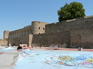
Castle of Abrantes
Castle in Abrantes, Santarém, Ribatejo, Portugal
Distance: Approx. 3904 meters
Latitude and longitude: 39.46445833,-8.19481944
The Castle of Abrantes (Portuguese: Fortaleza de Abrantes) overlooks the city of Abrantes, in the municipality of Abrantes in the district of Santarém, Ribatejo, divided between the two civil parishes of São João and São Vicente. It was part of the Reconquista fortifications that made up the Linha do Tejo (English: Tagus Line), a line of castles and outposts during the Middle Ages, recently integrated into a tourist region called the Região de Turismo dos Templários (English: Tourist Region of the Templars).
Abrantes (São Vicente e São João) e Alferrarede
Civil parish in Oeste e Vale do Tejo, Portugal
Distance: Approx. 4438 meters
Latitude and longitude: 39.47,-8.2
Union of Parishes of Abrantes e São Vicente e São João e Alferrarede is a freguesia ("civil parish") in the municipality of Abrantes on Santarém District Portugal. It was formed in 2013 by the merger of the former parishes São Vicente, São João and Alferrarede. The population in 2011 was 17,205, in an area of 64.47 km².

Abrantes railway station
Railway station in Portugal
Distance: Approx. 4525 meters
Latitude and longitude: 39.44027778,-8.19444444
Abrantes Station is a railway station in Abrantes, Santarém, Portugal.
Weather in this IP's area
clear sky
24 Celsius
23 Celsius
22 Celsius
25 Celsius
1022 hPa
27 %
1022 hPa
1011 hPa
10000 meters
1.79 m/s
3.13 m/s
346 degree
5 %
07:26:57
19:18:32