Country:
 Portugal
Region:
City:
Latitude and Longitude:
Time Zone:
Postal Code:
IP information under different IP Channel
ip-api
Country
Region
City
ASN
Time Zone
ISP
Blacklist
Proxy
Latitude
Longitude
Postal
Route
IPinfo
Country
Region
City
ASN
Time Zone
ISP
Blacklist
Proxy
Latitude
Longitude
Postal
Route
MaxMind
Country
Region
City
ASN
Time Zone
ISP
Blacklist
Proxy
Latitude
Longitude
Postal
Route
Luminati
Country
PTRegion
11
City
lisbon
ASN
Time Zone
Europe/Lisbon
ISP
Servicos De Comunicacoes E Multimedia S.A.
Latitude
Longitude
Postal
db-ip
Country
Region
City
ASN
Time Zone
ISP
Blacklist
Proxy
Latitude
Longitude
Postal
Route
ipdata
Country
Region
City
ASN
Time Zone
ISP
Blacklist
Proxy
Latitude
Longitude
Postal
Route
Popular places and events near this IP address

Santa Justa Lift
Municipal elevator in Lisbon, Portugal
Distance: Approx. 214 meters
Latitude and longitude: 38.71222222,-9.13944444
The Santa Justa Lift (Portuguese: Elevador de Santa Justa, pronounced [elɨvɐˈðoɾ ðɨ ˈsɐ̃tɐ ˈʒuʃtɐ]), also called Carmo Lift (Portuguese: Elevador do Carmo, [elɨvɐˈðoɾ ðu ˈkaɾmu]), is an elevator, or lift, in the civil parish of Santa Maria Maior, in the historic center of Lisbon, Portugal. Situated at the end of Rua de Santa Justa, it connects the lower streets of the Baixa with the higher Largo do Carmo (Carmo Square). Since its construction the lift has become a tourist attraction for Lisbon as, among the urban lifts in the city, Santa Justa is the only remaining vertical (conventional) one.
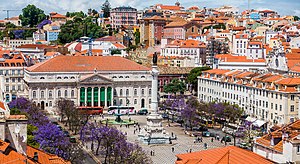
Lisbon Baixa
Neighborhood in Santa Maria Maior, Lisbon
Distance: Approx. 1 meters
Latitude and longitude: 38.71138889,-9.13722222
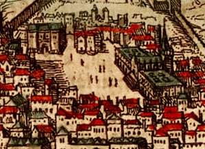
The Baixa ("Downtown"), also known as the Baixa Pombalina (IPA: [ˈbajʃɐ põbɐˈlinɐ]; "Pombaline Downtown"), is a neighborhood in the historic center of Lisbon, Portugal. It consists of the grid of streets north of the Praça do Comércio, roughly between the Cais do Sodré and the Alfama district beneath the Lisbon Castle, and extends northwards towards the Rossio and Figueira squares and the Avenida da Liberdade, a tree-lined boulevard noted for its tailoring shops and cafes.
Olisipo
Lisbon, Portugal in Roman times
Distance: Approx. 296 meters
Latitude and longitude: 38.7122204,-9.1339731
Municipium Cives Romanorum Felicitas Julia Olisipo (in Latin: Olisippo or Ulyssippo ; in Greek: Ὀλισσιπών, Olissipṓn, or Ὀλισσιπόνα, Olissipóna) was the ancient name of modern-day Lisbon while it was part of the Roman Empire.

Carmo Convent
Church in Lisbon, Portugal
Distance: Approx. 258 meters
Latitude and longitude: 38.71222222,-9.14
The Convent of Our Lady of Mount Carmel (Portuguese: Convento da Ordem do Carmo) is a former Catholic convent located in the civil parish of Santa Maria Maior, municipality of Lisbon, Portugal. The medieval convent was ruined during the sequence of the 1755 Lisbon earthquake, and the destroyed Gothic Church of Our Lady of Mount Carmel (Portuguese: Igreja do Carmo) on the southern facade of the convent is the main trace of the great earthquake still visible in the old city.
Hospital Real de Todos-os-Santos
Hospital in Lisbon, Portugal
Distance: Approx. 265 meters
Latitude and longitude: 38.7136,-9.13839
The Hospital Real de Todos-os-Santos (All Saints Royal Hospital) was a major hospital in Lisbon, Portugal. The hospital was built between 1492 and 1504 and was destroyed in the 1755 Lisbon earthquake, along with most of the city. It was never fully rebuilt and was finally demolished in 1775.

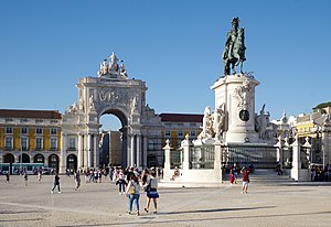
Praça da Figueira
Public square in Lisbon, Portugal
Distance: Approx. 211 meters
Latitude and longitude: 38.71277778,-9.13888889
The Praça da Figueira (Portuguese: [ˈpɾasɐ ðɐ fiˈɣɐjɾɐ], Square of the Fig Tree) is a large square in the centre of Lisbon, in Portugal. It is part of the Lisbon Baixa, the area of the city reurbanised after the 1755 Lisbon earthquake. In the 16th century the square did not exist, and most of its area was occupied by the Hospital Real de Todos os Santos (All-Saints Royal Hospital), the most important in the city.

Madalena, Lisbon
Civil parish in Lisbon, Portugal
Distance: Approx. 267 meters
Latitude and longitude: 38.71,-9.13472
Madalena (English: Magdalene) is a former civil parish (freguesia) in the city and municipality of Lisbon, Portugal. It has a total area of 0.11 km2 and total population of 380 inhabitants (2001); density: 3,423 inhabitants/km2. At the administrative reorganization of Lisbon on 8 December 2012 it became part of the parish Santa Maria Maior.
Sacramento, Lisbon
Distance: Approx. 258 meters
Latitude and longitude: 38.71222223,-9.14000001
Sacramento is a former civil parish (freguesia) in the city and municipality of Lisbon, Portugal. It had a total area of 0.08 km2 and total population of 880 inhabitants (2001); density: 18,864.2 inhabitants/km2. At the administrative reorganization of Lisbon on 8 December 2012 it became part of the parish Santa Maria Maior.

Igreja da Madalena
Distance: Approx. 230 meters
Latitude and longitude: 38.71027778,-9.135
Church of the Magdalene (Portuguese: Igreja da Madalena) is a church in Lisbon, Portugal. Its portal is classified as a National Monument.

Penafiel Palace
Palace in Santa Maria Maior, Portugal
Distance: Approx. 253 meters
Latitude and longitude: 38.71086111,-9.13438889
The Palace of the Counts of Penafiel (Portuguese: Palácio dos Condes de Penafiel), commonly known as Penafiel Palace (Palácio Penafiel) and also referred as Palace of the Postmaster-General (Palácio do Correio-Mor), is a palace in Portugal, located in the Santa Maria Maior parish, Lisbon. It presently serves as the global headquarters of the Community of Portuguese Language Countries, also known as the Lusophone Community.
Santa Maria Maior, Lisbon
Civil parish in Lisbon, Portugal
Distance: Approx. 207 meters
Latitude and longitude: 38.713,-9.136
Santa Maria Maior (Portuguese pronunciation: [ˈsɐ̃tɐ mɐˈɾi.ɐ mɐˈjɔɾ]) is a freguesia (civil parish) and district of Lisbon, the capital of Portugal. Located in the historic center of Lisbon, Santa Maria Maior is to the west of São Vicente, east of Misericórdia, and south of Arroios and Santo António. It is home to numerous historic monuments, including Lisbon Cathedral, the Rossio, and the Praça do Comércio, as well as famous neighborhoods, such as the Lisbon Baixa, as well as parts of Bairro Alto and Alfama.

Baixa-Chiado Station
Metro station in Lisbon, Portugal
Distance: Approx. 259 meters
Latitude and longitude: 38.71055556,-9.14
Baixa-Chiado is an interchange station where the Blue and Green Lines of the Lisbon Metro connect, being located under Rua Ivens between Baixa and Chiado, hence its name.
Weather in this IP's area
clear sky
22 Celsius
21 Celsius
20 Celsius
23 Celsius
1022 hPa
43 %
1022 hPa
1019 hPa
10000 meters
3.09 m/s
70 degree
07:30:44
19:22:39