Country:
 Russian Federation
Region:
City:
Latitude and Longitude:
Time Zone:
Postal Code:
IP information under different IP Channel
ip-api
Country
Region
City
ASN
Time Zone
ISP
Blacklist
Proxy
Latitude
Longitude
Postal
Route
IPinfo
Country
Region
City
ASN
Time Zone
ISP
Blacklist
Proxy
Latitude
Longitude
Postal
Route
MaxMind
Country
Region
City
ASN
Time Zone
ISP
Blacklist
Proxy
Latitude
Longitude
Postal
Route
Luminati
Country
RUASN
Time Zone
Europe/Moscow
ISP
Joint Stock Company TransTeleCom
Latitude
Longitude
Postal
db-ip
Country
Region
City
ASN
Time Zone
ISP
Blacklist
Proxy
Latitude
Longitude
Postal
Route
ipdata
Country
Region
City
ASN
Time Zone
ISP
Blacklist
Proxy
Latitude
Longitude
Postal
Route
Popular places and events near this IP address
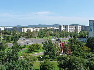
Komsomolsk-on-Amur
Town in Khabarovsk Krai, Russia
Distance: Approx. 1955 meters
Latitude and longitude: 50.56666667,137
Komsomolsk-on-Amur (Russian: Комсомольск-на-Амуре, romanized: Komsomolsk-na-Amure, IPA: [kəmsɐˈmolʲsk nɐɐˈmurʲə]) is a city in Khabarovsk Krai, Russia, located on the west bank of the Amur River in the Russian Far East. It is located on the Baikal-Amur Mainline, 356 kilometers (221 mi) northeast of Khabarovsk. Population: 238,505 (2021 Census); 263,906 (2010 Russian census); 281,035 (2002 Census); 315,325 (1989 Soviet census).

Dzyomgi Airport
Airport in Komsomolsk-na-Amure
Distance: Approx. 7542 meters
Latitude and longitude: 50.605,137.08166667
Dzyomgi Airport (Russian: Аэропорт Дзёмги) (ICAO: UHKD) is an air base in Khabarovsk Krai, Russia, located 8 kilometres (5 mi) northeast of Komsomolsk-na-Amure. Dzyomgi is Komsomolsk-na-Amure's northeast side airport, handling small airliner traffic. On May 7, 1939, at the airfield, the formation of the 60th Fighter Aviation Regiment began on I-16 aircraft.

Komsomolsk-on-Amur Aircraft Plant
Russian aerospace manufacturer
Distance: Approx. 6924 meters
Latitude and longitude: 50.59194444,137.09027778
Komsomolsk-on-Amur Aircraft Plant (KnAAPO or KnAAZ; Russian: Комсомольский-на-Амуре авиационный завод); based in Komsomolsk-on-Amur in the Russian Far East, is the largest aircraft-manufacturing company in Russia. The company is among Khabarovsk Krai's most successful enterprises, and for years has been the largest taxpayer of the territory. In 1999 and 2001 the Russian Union of Industrialists and Entrepreneurs and the Chamber of Commerce and Industry of RF granted KnAAPO the title "best Russian enterprise".

Amur Shipbuilding Plant
Distance: Approx. 2083 meters
Latitude and longitude: 50.54788056,137.04392778
OJSC Amur Shipbuilding Plant (Russian: Амурский судостроительный завод, Amurskiy Sudostroitelnyy Zavod, and also called the "Leninskiy Komsomol Shipyard") is an important shipyard in eastern Russia, based in Komsomolsk-on-Amur, and founded in 1932. It employs 15,000 people, and produces both civilian and military ships, including nuclear submarines. Around 97 submarines (56 nuclear-powered and 41 conventional) as well as 36 warships were built at the yard.

Komsomolsky District, Khabarovsk Krai
District in Khabarovsk Krai, Russia
Distance: Approx. 1955 meters
Latitude and longitude: 50.56666667,137
Komsomolsky District (Russian: Комсомо́льский райо́н) is an administrative and municipal district (raion), one of the seventeen in Khabarovsk Krai, Russia. It is located in the southern central part of the krai. The area of the district is 25,167 square kilometers (9,717 sq mi).

Komsomolsk-on-Amur road-rail bridge
Railway Bridge Of Russia
Distance: Approx. 8700 meters
Latitude and longitude: 50.4746,137.0322
The bridge across the Amur River (in Komsomolsk-on-Amur) is a road-rail bridge across the Amur River near the city of Komsomolsk-on-Amur. The bridge has a single-rail track and two-lane highway that allows to completely divide cars and other vehicles from trains. The bridge carries also a single-circuit 220 kV-powerline.

Komsomolsk-on-Amur railway station
Railway station in Russia
Distance: Approx. 1802 meters
Latitude and longitude: 50.55194444,136.98972222
Komsomolsk-on-Amur railway station is a railway station in Komsomolsk-on-Amur, Russia. Trains follow from the station in four directions: In the direction of Khabarovsk - freight and passenger traffic. In the direction of Tynda (BAM) - freight and passenger traffic.
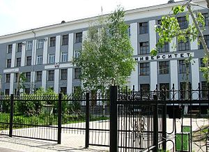
Komsomolsk-on-Amur State University
State university in Russia
Distance: Approx. 981 meters
Latitude and longitude: 50.5468502,137.0039371
Komsomolsk-on-Amur State University (Russian: «Федеральное государственное бюджетное образовательное учреждение высшего образования „Комсомольский-на-Амуре государственный университет“» is a university located in Komsomolsk-on-Amur, a city in the Khabarovsk Krai in the Russian Far East.
Weather in this IP's area
broken clouds
16 Celsius
15 Celsius
16 Celsius
16 Celsius
1006 hPa
74 %
1006 hPa
1002 hPa
10000 meters
6.26 m/s
12.25 m/s
359 degree
79 %
05:14:50
20:41:47