Country:
 Great Britain
Region:
City:
Latitude and Longitude:
Time Zone:
Postal Code:
IP information under different IP Channel
ip-api
Country
Region
City
ASN
Time Zone
ISP
Blacklist
Proxy
Latitude
Longitude
Postal
Route
IPinfo
Country
Region
City
ASN
Time Zone
ISP
Blacklist
Proxy
Latitude
Longitude
Postal
Route
MaxMind
Country
Region
City
ASN
Time Zone
ISP
Blacklist
Proxy
Latitude
Longitude
Postal
Route
Luminati
Country
 ZA
ZARegion
gp
City
johannesburg
ASN
Time Zone
Africa/Johannesburg
ISP
TIGGEE
Latitude
Longitude
Postal
db-ip
Country
Region
City
ASN
Time Zone
ISP
Blacklist
Proxy
Latitude
Longitude
Postal
Route
ipdata
Country
Region
City
ASN
Time Zone
ISP
Blacklist
Proxy
Latitude
Longitude
Postal
Route
Popular places and events near this IP address
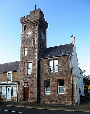
Ayton, Scottish Borders
Village in Scottish Borders, Scotland, UK
Distance: Approx. 3859 meters
Latitude and longitude: 55.842515,-2.123012
Ayton is a small village located in the historic county of Berwickshire, today part of the Scottish Borders region. It is on the Eye Water, from which it is said to take its name: Ayton means 'Eye-town'. It contains the former ancient tollbooth or town hall with a clock tower, the Hemelvaart Bier Cafe (an entertainment venue as well as a bar) and a village store.

Coldingham
Village and parish in Scotland
Distance: Approx. 3851 meters
Latitude and longitude: 55.8833,-2.1666
Coldingham is a village and parish in Berwickshire in the Scottish Borders. It lies a short distance inland from Coldingham Bay, three miles northeast of the fishing village of Eyemouth.
Auchencrow
Village in Scottish Borders, Scotland, UK
Distance: Approx. 3714 meters
Latitude and longitude: 55.84,-2.24
Auchencrow (Scottish Gaelic: Allt na Crà) is a small village in the Scottish Borders area of Scotland, by the Lammermuir range of hills, and near Reston.

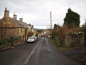
Reston, Scottish Borders
Village in Scottish Borders, Scotland
Distance: Approx. 629 meters
Latitude and longitude: 55.851,-2.1932
Reston is a village located in the southeast of Scotland, in Berwickshire, Scottish Borders region. The village lies on the western bank of the Eye Water.

A1107 road
Road in Scotland
Distance: Approx. 5064 meters
Latitude and longitude: 55.8915,-2.2165
The A1107 is a road in south-east Scotland, in the Scottish Borders. It is a non-trunk route from near Cockburnspath to near Burnmouth. It follows the route Burnmouth – Eyemouth – Coldingham – Old Cambus – Pease Bay – Cockburnspath.

Coldingham Priory
Church in Scottish Borders, Scotland, UK
Distance: Approx. 4425 meters
Latitude and longitude: 55.8865,-2.15522222
Coldingham Priory was a house of Benedictine monks. It lies on the south-east coast of Scotland, in the village of Coldingham, Berwickshire. Coldingham Priory was founded in the reign of David I of Scotland, although his older brother and predecessor King Edgar of Scotland had granted the land of Coldingham to the Church of Durham in 1098, and a church was constructed by him and presented in 1100.

Ayton railway station
Disused railway station in Ayton, Scottish Borders
Distance: Approx. 4473 meters
Latitude and longitude: 55.838,-2.115
Ayton railway station was a station which served the village of Ayton in the Scottish area of Scottish Borders. It was located on what is now known as the East Coast Main Line. The station was also served by trains on the Berwickshire Railway which diverged from the main line at Reston.
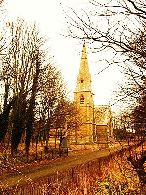
Ayton Parish Church
Distance: Approx. 4220 meters
Latitude and longitude: 55.841,-2.1177
Ayton and Burnmouth Parish Church is a member church (Scots: kirk) of the Church of Scotland, serving the communities of Ayton and Burnmouth in the Scottish Borders. The church is situated on the side of the B6355 road, just off the main A1 road, 0.5 miles (0.80 km) south of the village centre and 6.5 miles (10.5 km) north-west of Berwick upon Tweed, at grid reference NT927609.
Press Castle
Village in Scottish Borders, Scotland, UK
Distance: Approx. 3827 meters
Latitude and longitude: 55.88155,-2.20765
Press Castle is a village with 17th-century manor house and country estate in the Scottish Borders, 2m (3 km) west of Coldingham, by the Ale Water. NT871654. The area is renowned for its colonies of red squirrels.

Chirnside United F.C.
Association football club in Scotland
Distance: Approx. 5423 meters
Latitude and longitude: 55.80328,-2.20785
Chirnside United Football Club, previously known as Chirnside F.C., is a Scottish amateur football club based in the village of Chirnside in the Scottish Borders. They play in the 'A league' of the Border Amateur Football League, which is affiliated to the Scottish Amateur Football Association. Their home ground is Comrades Park.
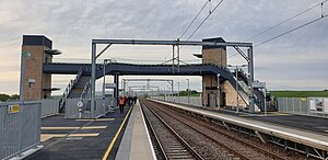
Reston railway station
Railway station in the Scottish Borders council area
Distance: Approx. 871 meters
Latitude and longitude: 55.8506,-2.1972
Reston is a railway station in the small village of Reston that serves the wider rural parish of Coldingham and nearby small town of Eyemouth in the eastern Scottish Borders council area. The station is a minor stop on the East Coast Main Line and opened on 23 May 2022 after a £20 million investment. The station is owned by Network Rail and managed by ScotRail, although the latter company does not provide any services to or from the station.
Billie Castle
Architectural structure in Scottish Borders, Scotland, UK
Distance: Approx. 4197 meters
Latitude and longitude: 55.8298,-2.24
Billie Castle is a ruined 15th-century quadrangular castle, 3 miles (4.8 km) north west of Chirnside, Scottish Borders, Scotland, north of Billiemains. It was designated as a scheduled monument in 1988.
Weather in this IP's area
overcast clouds
16 Celsius
16 Celsius
16 Celsius
16 Celsius
1022 hPa
83 %
1022 hPa
1014 hPa
10000 meters
3.65 m/s
6.33 m/s
195 degree
100 %
05:06:42
21:23:31