Country:
 Croatia
Region:
City:
Latitude and Longitude:
Time Zone:
Postal Code:
IP information under different IP Channel
ip-api
Country
Region
City
ASN
Time Zone
ISP
Blacklist
Proxy
Latitude
Longitude
Postal
Route
IPinfo
Country
Region
City
ASN
Time Zone
ISP
Blacklist
Proxy
Latitude
Longitude
Postal
Route
MaxMind
Country
Region
City
ASN
Time Zone
ISP
Blacklist
Proxy
Latitude
Longitude
Postal
Route
Luminati
Country
HRASN
Time Zone
Europe/Zagreb
ISP
SEEWEB s.r.l.
Latitude
Longitude
Postal
db-ip
Country
Region
City
ASN
Time Zone
ISP
Blacklist
Proxy
Latitude
Longitude
Postal
Route
ipdata
Country
Region
City
ASN
Time Zone
ISP
Blacklist
Proxy
Latitude
Longitude
Postal
Route
Popular places and events near this IP address

Pula
City in Istria County, Croatia
Distance: Approx. 274 meters
Latitude and longitude: 44.87027778,13.84555556
Pula (Croatian: [pǔːla] ), also known as Pola (Italian: [ˈpɔːla]; Venetian: Pola; Istriot: Puola; Slovene: Pulj; Hungarian: Póla), is the largest city in Istria County, Croatia, and the seventh-largest city in the country, situated at the southern tip of the Istrian peninsula in northwestern Croatia, with a population of 52,220 in 2021. It is known for its multitude of ancient Roman buildings, the most famous of which is the Pula Arena, one of the best preserved Roman amphitheaters. The city has a long tradition of wine making, fishing, shipbuilding, and tourism.

Pula Arena
Roman amphitheatre in Pula, Croatia
Distance: Approx. 541 meters
Latitude and longitude: 44.873,13.85
The Pula Arena (Croatian: Pulska Arena; Italian: Arena di Pola) is a Roman amphitheatre located in Pula, Croatia. It is the only remaining Roman amphitheatre to have four side towers entirely preserved. It was constructed between 27 BC and AD 68, and is among the world's six largest surviving Roman arenas.
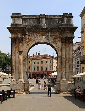
Arch of the Sergii
Triumphal arch in Pula, Croatia
Distance: Approx. 72 meters
Latitude and longitude: 44.8683,13.8469
Arch of the Sergii (Croatian: Slavoluk Sergijevaca) is an Ancient Roman triumphal arch located in Pula, Croatia. The arch commemorates three members of the Sergii family, specifically Lucius Sergius Lepidus, a tribune serving in the twenty-ninth legion that participated in the Battle of Actium and disbanded in 27 BC. This suggests an approximate date of construction: 29–27 BC. The arch stood behind the original naval gate of the early Roman colony. The Sergii were a powerful family of officials in the colony and retained their power for centuries.

Juraj Dobrila University of Pula
Public university in Pula, Croatia
Distance: Approx. 508 meters
Latitude and longitude: 44.867291,13.854044
The Juraj Dobrila University of Pula (Croatian: Sveučilište Jurja Dobrile u Puli, Latin: Universitas studiorum Polensis Georgii Dobrila) is a university in Pula, Croatia. It was founded in 2006 and has eleven constituents.
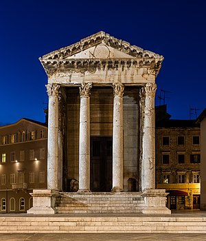
Temple of Augustus, Pula
Roman temple in Pula, Croatia
Distance: Approx. 514 meters
Latitude and longitude: 44.8702,13.8418
The Temple of Augustus (Croatian: Augustov hram; Italian: Tempio di Augusto) is a well-preserved Roman temple in the city of Pula, Croatia (known in Roman times as Pietas Iulia). Dedicated to the first Roman emperor, Augustus, it was probably built during the emperor's lifetime at some point between 27 BC and his death in AD 14. It was built on a podium with a tetrastyle prostyle porch of Corinthian columns and measures about 8 by 17.3 m (26 by 57 ft), and 14 m (46 ft) high.
German submarine U-81 (1941)
Type VIIC U-boat of the navy of Nazi Germany (Kriegsmarine)
Distance: Approx. 260 meters
Latitude and longitude: 44.86666667,13.85
German submarine U-81 was a Type VIIC U-boat of the navy (Kriegsmarine) of Nazi Germany during World War II, famous for sinking the aircraft carrier HMS Ark Royal.

Premantura
Village in Istria County, Croatia
Distance: Approx. 260 meters
Latitude and longitude: 44.86666667,13.85
Premantura (Italian: Promontore) is a small village in the municipality of Medulin in Istria, on the southernmost tip Istrian Peninsula, just south of the city of Pula. A short distance from Premantura is Cape Kamenjak – a small peninsula consisting of more than 30 km of coastline with several coves and beaches. In the southernmost part of Istria (county of the Julian region), on a sliver land surrounded by the sea and perched on the top of a hill, there lies a small and ancient village.

Pula Communal Palace
City hall of Pula, Croatia
Distance: Approx. 260 meters
Latitude and longitude: 44.86666667,13.85
The local government of the City of Pula is seated in the Communal Palace (Croatian: Komunalna palača u Puli; Italian: Palazzo Comunale), located on the Forum Square, in the center of the city.

Pula Cathedral
Church in Pula, Croatia
Distance: Approx. 450 meters
Latitude and longitude: 44.87166667,13.84444444
The Pula Cathedral or fully the Cathedral of the Assumption of the Blessed Virgin Mary (Croatian: Katedrala uznesenja Blažene Djevice Marije) is a co-cathedral in Pula, Croatia. Along with the Euphrasian Basilica it is one of the two official seats of the Roman Catholic Diocese of Poreč and Pula. The church is located on the south side of the Pula bay at the foot of the hill with the 17th century Venetian fort.

Santa Maria del Canneto (Pula, Croatia)
Distance: Approx. 334 meters
Latitude and longitude: 44.86802778,13.8436
The Basilica of Santa Maria del Canneto, or Santa Maria Formosa, was a sixth-century Byzantine church erected in Pola (modern-day Pula, Croatia) under the patronage of Maximianus, bishop of Ravenna. The structure was damaged at the time of the Venetian sack of Pola in 1243, and building material was subsequently taken from the ruins and primarily incorporated into the Marciana Library and the Basilica of Saint Mark in Venice. Of the large, triple-nave church, comparable in splendour to the Euphrasian Basilica in Parenzo (modern-day Poreč), only one of the lateral chapels survives.
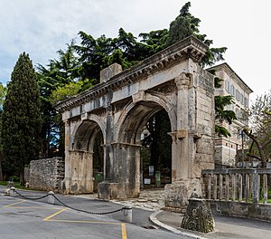
Porta Gemina
2nd-century Roman triumphal arch in Pula, Croatia
Distance: Approx. 280 meters
Latitude and longitude: 44.87091667,13.84775
The Dvojna vrata (Porta Gemina) is a Roman city gate located in Pula, Croatia. It was built during the late 2nd century. Porta Gemina is a double arched gate.

Monastery and Church of St. Francis in Pula
Church in Pula, Croatia
Distance: Approx. 371 meters
Latitude and longitude: 44.86991667,13.84361111
The Monastery and Church of St. Francis in Pula are located on the western slope of the Pula hill, halfway between the Forum and the medieval fortress at the top, on the site where previously was the early Christian complex of St. John the Baptist.
Weather in this IP's area
clear sky
24 Celsius
24 Celsius
24 Celsius
24 Celsius
1017 hPa
60 %
1017 hPa
1015 hPa
10000 meters
0.51 m/s
05:47:09
20:34:47