Country:
 France
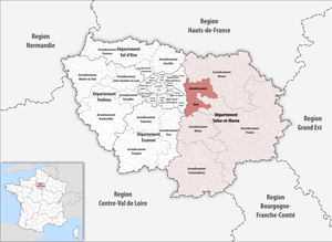
Region:
City:
Latitude and Longitude:
Time Zone:
Postal Code:
IP information under different IP Channel
ip-api
Country
Region
City
ASN
Time Zone
ISP
Blacklist
Proxy
Latitude
Longitude
Postal
Route
IPinfo
Country
Region
City
ASN
Time Zone
ISP
Blacklist
Proxy
Latitude
Longitude
Postal
Route
MaxMind
Country
Region
City
ASN
Time Zone
ISP
Blacklist
Proxy
Latitude
Longitude
Postal
Route
Luminati
Country
FRRegion
idf
City
paris
ASN
Time Zone
Europe/Paris
ISP
Eurofiber France SAS
Latitude
Longitude
Postal
db-ip
Country
Region
City
ASN
Time Zone
ISP
Blacklist
Proxy
Latitude
Longitude
Postal
Route
ipdata
Country
Region
City
ASN
Time Zone
ISP
Blacklist
Proxy
Latitude
Longitude
Postal
Route
Popular places and events near this IP address

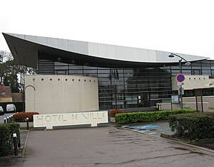
Torcy, Seine-et-Marne
Subprefecture and commune in Île-de-France, France
Distance: Approx. 2244 meters
Latitude and longitude: 48.8502,2.6508
Torcy (French pronunciation: [tɔʁsi]) is a commune in the Seine-et-Marne department, Île-de-France, north-central France. It is located in the eastern suburbs of Paris, 21.8 km (13.5 mi) from the center of Paris. Torcy is a sub-prefecture of the department and the seat of an arrondissement.
Arrondissement of Torcy
Arrondissement in Île-de-France, France
Distance: Approx. 2269 meters
Latitude and longitude: 48.85111111,2.64972222
The arrondissement of Torcy is an arrondissement of France in the Seine-et-Marne department in the Île-de-France region. It has 50 communes. Its population is 459,961 (2019), and its area is 381.8 km2 (147.4 sq mi).

Lognes
Commune in Île-de-France, France
Distance: Approx. 174 meters
Latitude and longitude: 48.836,2.6278
Lognes (French pronunciation: [lɔɲ] ) is a community in the eastern suburbs of Paris, France. It is located in the Seine-et-Marne department in the Île-de-France 20.7 km (12.9 mi) from the center of Paris. The community of Lognes is part of the Val Maubuée sector, one of the four sectors in the "new town" of Marne-la-Vallée.

Noisiel
Commune in Île-de-France, France
Distance: Approx. 2150 meters
Latitude and longitude: 48.8547,2.6289
Noisiel (French pronunciation: [nwazjɛl] ) is a commune in the French department of Seine-et-Marne, administrative region of Île-de-France. It is located in the eastern suburbs of Paris, 20.5 km (12.7 mi) from the center of Paris. The commune of Noisiel is part of the Val Maubuée sector, one of the four sectors in the "new town" of Marne-la-Vallée.

Canton of Champs-sur-Marne
Canton in Île-de-France, France
Distance: Approx. 1330 meters
Latitude and longitude: 48.83222222,2.6125
The canton of Champs-sur-Marne is a French administrative division, located in the arrondissement of Torcy, in the Seine-et-Marne département (Île-de-France région).
Canton of Noisiel
Former canton in Île-de-France, France
Distance: Approx. 1162 meters
Latitude and longitude: 48.84583333,2.62944444
The canton of Noisiel is a French former administrative division, located in the arrondissement of Torcy, in the Seine-et-Marne département (Île-de-France région). It was disbanded following the French canton reorganisation which came into effect in March 2015. It consisted of 2 communes, which joined the canton of Champs-sur-Marne in 2015.

Croissy-Beaubourg
Commune in Île-de-France, France
Distance: Approx. 2346 meters
Latitude and longitude: 48.8292,2.6606
Croissy-Beaubourg (French pronunciation: [kʁwasi bobuːʁ] ) is a French commune located in the Seine-et-Marne département, in the Île-de-France région.
Émerainville
Commune in Île-de-France, France
Distance: Approx. 2778 meters
Latitude and longitude: 48.8108,2.6236
Émerainville (French pronunciation: [em(ə)ʁɛ̃vil] ) is a commune in the Seine-et-Marne département in the Île-de-France region in north-central France.

Torcy station
Railway station in Torcy, France
Distance: Approx. 1864 meters
Latitude and longitude: 48.8394,2.6547
Torcy station (French pronunciation: [toʁsi]) is a railway station in Torcy, Seine-et-Marne, a suburb east of Paris.

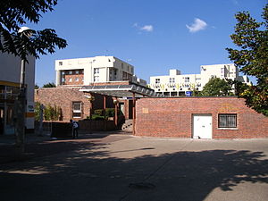
Lognes station
Distance: Approx. 483 meters
Latitude and longitude: 48.8389,2.6339
Lognes station is a railway station on RER train network in Lognes, Seine-et-Marne.
Noisiel station
Distance: Approx. 1313 meters
Latitude and longitude: 48.8433,2.6167
Noisiel station is a railway station on the Réseau Express Régional train network in Noisiel, Seine-et-Marne.
Communauté d'agglomération Paris - Vallée de la Marne
Communauté d'agglomération in Île-de-France, France
Distance: Approx. 2188 meters
Latitude and longitude: 48.85,2.65
The Communauté d'agglomération Paris - Vallée de la Marne is a communauté d'agglomération in the Seine-et-Marne département and in the Île-de-France région of France. It was formed on 1 January 2016 by the merger of the former Communauté d'agglomération de Marne et Chantereine, Communauté d'agglomération de Marne-la-Vallée - Val Maubuée and Communauté d'agglomération de la Brie Francilienne. Its seat is in Torcy.
Weather in this IP's area
clear sky
18 Celsius
17 Celsius
16 Celsius
19 Celsius
1023 hPa
81 %
1023 hPa
1012 hPa
10000 meters
3.03 m/s
7.97 m/s
71 degree
1 %
06:19:13
21:32:27