Country:
 Russian Federation
Region:
City:
Latitude and Longitude:
Time Zone:
Postal Code:
IP information under different IP Channel
ip-api
Country
Region
City
ASN
Time Zone
ISP
Blacklist
Proxy
Latitude
Longitude
Postal
Route
IPinfo
Country
Region
City
ASN
Time Zone
ISP
Blacklist
Proxy
Latitude
Longitude
Postal
Route
MaxMind
Country
Region
City
ASN
Time Zone
ISP
Blacklist
Proxy
Latitude
Longitude
Postal
Route
Luminati
Country
RUASN
Time Zone
Europe/Moscow
ISP
Joint Stock Company TransTeleCom
Latitude
Longitude
Postal
db-ip
Country
Region
City
ASN
Time Zone
ISP
Blacklist
Proxy
Latitude
Longitude
Postal
Route
ipdata
Country
Region
City
ASN
Time Zone
ISP
Blacklist
Proxy
Latitude
Longitude
Postal
Route
Popular places and events near this IP address

Chita Oblast
Former federal subject of Russia
Distance: Approx. 3424 meters
Latitude and longitude: 52.03333333,113.5
Chita Oblast (Russian: Чити́нская о́бласть, romanized: Čitínskaja óblastj, IPA: [tɕɪˈtʲinskəjə ˈobləsʲtʲ]) was a federal subject of Russia (an oblast) in southeast Siberia, Russia. Its administrative center was the city of Chita. It had extensive international borders with China (998 km) and Mongolia (868 km) and internal borders with Irkutsk and Amur Oblasts, as well as with the republics of Buryatia and Yakutia.
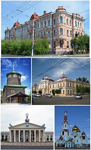
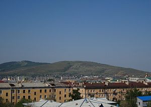
Chita, Zabaykalsky Krai
City in Zabaykalsky Krai, Russia
Distance: Approx. 6001 meters
Latitude and longitude: 52.05,113.46666667
Chita (Russian: Чита, IPA: [tɕɪˈta]) is a city and the administrative center of Zabaykalsky Krai, Russia, located on the Trans-Siberian Railway route, roughly 900 kilometers (560 mi) east of Irkutsk.
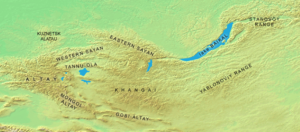
Yablonoi Mountains
Mountain range in Siberia, Russia
Distance: Approx. 2944 meters
Latitude and longitude: 52.05,113.58333333
The Yablonoi Mountains or Yablonovy Mountains (Russian: Яблоновый хребет, Buryat: Яабланай шэлэ нуруу, Yaablanai shele nuruu; Mongolian: Яблоны нуруу, Yablony nuruu) are a mountain range, in Transbaikal (mainly in Zabaykalsky Krai), Siberia, Russia. The range is sparsely inhabited with most settlements engaged in mining. The area is especially rich in tin.
Transbaikal State University
University in Chita, Russia
Distance: Approx. 1453 meters
Latitude and longitude: 52.032074,113.528882
Transbaikal State University (Russian: Забайкальский государственный университет) is an institution of higher education in Chita, Russia. It is the largest educational, scientific and innovative center in Zabaykalsky Krai. Transbaikal State University (until 2011: Chita State University) was established in 1974 on the base of the Technology Department of Irkutsk Technical Institute which was opened earlier in 1966.

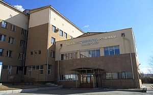
Chita State Academy of Medicine
Institution of higher education
Distance: Approx. 2772 meters
Latitude and longitude: 52.0371,113.51
The Chita State Academy of Medicine (Russian: Читинская Государственная Медицинская Академия) is an institution of higher education in Chita, Russia. It was founded on 23 July 1953 as the Chita State Institute of Medicine. The institute was composed of the lecturers of the Perm Dentist Institute evacuated to Chita during World War II. Following the collapse of the Soviet Union, the Chita State Institute of Medicine was renamed in 1995 when it was granted the new status becoming the Chita State Academy of Medicine.

Lokomotiv Stadium (Chita)
Multi-use stadium in Chita, Russia
Distance: Approx. 5348 meters
Latitude and longitude: 52.04059,113.4728
Lokomotiv Stadium is a multi-use stadium in Chita, Russia. It is used mostly for football matches. The stadium holds 12,500 people.

Chitinka
River in Russia
Distance: Approx. 3462 meters
Latitude and longitude: 52.00777778,113.52111111
The Chitinka (Russian: Читинка, also Чита Chita) is a river in Zabaykalsky Krai in Russia. It is a left tributary of the Ingoda (in Amur's drainage basin). It is 210 kilometres (130 mi) long, and has a drainage basin of 4,200 square kilometres (1,600 sq mi).

State of Buryat-Mongolia
1917–1921 state in East Asia
Distance: Approx. 6001 meters
Latitude and longitude: 52.05,113.46666667
The State of Buryat-Mongolia was a buffer Buryat-Mongolian state, during the Russian Civil War. The main government body was Burnatskom, the Buryat National Committee.
Eastern Okraina
State
Distance: Approx. 6001 meters
Latitude and longitude: 52.05,113.46666667
The Russian Eastern Okraina (Russian: Российская Восточная Окраина) was a local government that existed in the Russian Far East region in 1920 during the Russian Civil War of 1917–1923.
Yunost Stadium (Oral)
Distance: Approx. 5388 meters
Latitude and longitude: 52.04245,113.47274
Yunost Stadium (or Zhastar Stadium in Kazakh:[1]) (Russian: Стадион «Юность», lit. 'Youth Stadium') is a sports stadium in Oral, Kazakhstan. The stadium is used for the home games of bandy team Akzhayik Sports Club. Starting in the 2017–18 season, the stadium was supposed to have an artificial ice surface.

Chita railway station
Railway station in Chita, Russia
Distance: Approx. 3799 meters
Latitude and longitude: 52.02842222,113.4951
Chita Railway Station is the primary passenger railway station for the city of Chita in Russia, and an important stop along the Trans-Siberian Railway.
Titovskaya Sopka
A mountain massif in Russia
Distance: Approx. 5782 meters
Latitude and longitude: 52.025,113.46666667
Titovskaya Sopka is a mountain massif (max. elevation 944.7 m), valuable natural-historical territory, complex geological natural monument of local significance (paleontological, petrographic and geomorphological types according to the scientific classification of geological heritage objects). It is located on the southwestern outskirts of Chita, near the confluence of the Ingoda and Chitinka Rivers.
Weather in this IP's area
overcast clouds
30 Celsius
29 Celsius
30 Celsius
30 Celsius
998 hPa
28 %
998 hPa
909 hPa
10000 meters
2.68 m/s
3.1 m/s
174 degree
100 %
05:42:50
21:21:29