Country:
 Switzerland
Region:
City:
Latitude and Longitude:
Time Zone:
Postal Code:
IP information under different IP Channel
ip-api
Country
Region
City
ASN
Time Zone
ISP
Blacklist
Proxy
Latitude
Longitude
Postal
Route
IPinfo
Country
Region
City
ASN
Time Zone
ISP
Blacklist
Proxy
Latitude
Longitude
Postal
Route
MaxMind
Country
Region
City
ASN
Time Zone
ISP
Blacklist
Proxy
Latitude
Longitude
Postal
Route
Luminati
Country
CHRegion
vs
City
saillon
ASN
Time Zone
Europe/Zurich
ISP
netplus.ch SA
Latitude
Longitude
Postal
db-ip
Country
Region
City
ASN
Time Zone
ISP
Blacklist
Proxy
Latitude
Longitude
Postal
Route
ipdata
Country
Region
City
ASN
Time Zone
ISP
Blacklist
Proxy
Latitude
Longitude
Postal
Route
Popular places and events near this IP address
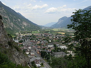
Vernayaz
Municipality in Valais, Switzerland
Distance: Approx. 582 meters
Latitude and longitude: 46.13333333,7.03333333
Vernayaz is a municipality in the district of Saint-Maurice, in the canton of Valais, Switzerland.
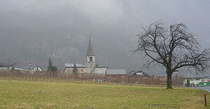
Collonges, Switzerland
Municipality in Valais, Switzerland
Distance: Approx. 3365 meters
Latitude and longitude: 46.16666667,7.03333333
Collonges (French pronunciation: [kɔlɔ̃ʒ]) is a municipality in the district of Saint-Maurice in the canton of Valais in Switzerland.
Dorénaz
Municipality in Valais, Switzerland
Distance: Approx. 1703 meters
Latitude and longitude: 46.15,7.05
Dorénaz is a municipality in the district of Saint-Maurice in the canton of Valais in Switzerland.

Salvan, Switzerland
Swiss municipality
Distance: Approx. 2823 meters
Latitude and longitude: 46.11666667,7.01666667
Salvan (French pronunciation: [salvɑ̃]) is a municipality in the district of Saint-Maurice, in the canton of Valais, Switzerland.

Gueuroz Bridge
Bridge in Valais, Switzerland
Distance: Approx. 909 meters
Latitude and longitude: 46.1286,7.04056
The Gueuroz Bridge is a reinforced concrete arched bridge in Switzerland.
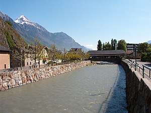
Drance
River in Switzerland
Distance: Approx. 2423 meters
Latitude and longitude: 46.12527778,7.06583333
The Drance (French: La Drance/Dranse, French pronunciation: [dʁɑ̃s]) is a river in Valais, Switzerland with a length of 14.5 kilometers (9.0 mi) to the confluence with the Rhône, a maximum length of 43 kilometers (27 mi). It has a drainage basin of 676 square kilometers (261 sq mi). The river is formed from the confluence of the Dranse d'Entremont and the Dranse de Bagnes at the village of Sembrancher.
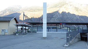
Vernayaz railway station
Distance: Approx. 213 meters
Latitude and longitude: 46.13854611,7.03835889
Vernayaz railway station (French: Gare de Vernayaz, German: Bahnhof Vernayaz) is a railway station in the municipality of Vernayaz, in the Swiss canton of Valais. It is an intermediate stop on the Simplon line and is served by local trains only.

Trient (river)
River in Switzerland
Distance: Approx. 955 meters
Latitude and longitude: 46.13777778,7.05138889
The Trient (French pronunciation: [tʁiɛ̃]) is a river in western Valais. It takes its source at the Trient Glacier in the Mont Blanc Massif and joins the Rhone between Vernayaz and Martigny. Only two villages are located along the Trient: Trient and Vernayaz.
Les Fumeaux railway station
Train station in Switzerland
Distance: Approx. 3557 meters
Latitude and longitude: 46.11008,7.06460806
Les Fumeaux railway station (French: Gare des Fumeaux) is a railway station in the municipality of Martigny, in the Swiss canton of Valais. It is located on the 1,000 mm (3 ft 3+3⁄8 in) gauge Martigny–Châtelard line of Transports de Martigny et Régions.

Vernayaz MC railway station
Distance: Approx. 819 meters
Latitude and longitude: 46.13041389,7.04460806
Vernayaz MC railway station (French: Gare de Vernayaz MC) is a railway station in the municipality of Vernayaz, in the Swiss canton of Valais. It is located on the 1,000 mm (3 ft 3+3⁄8 in) gauge Martigny–Châtelard line of Transports de Martigny et Régions. The depot for the line is located just south of the entrance to the station.

Salvan railway station
Distance: Approx. 2182 meters
Latitude and longitude: 46.12161194,7.02104889
Salvan railway station (French: Gare de Salvan) is a railway station in the municipality of Salvan, in the Swiss canton of Valais. It is located on the 1,000 mm (3 ft 3+3⁄8 in) gauge Martigny–Châtelard line of Transports de Martigny et Régions.

Les Marécottes railway station
Distance: Approx. 3441 meters
Latitude and longitude: 46.11231194,7.01169194
Les Marécottes railway station (French: Gare des Marécottes) is a railway station in the municipality of Salvan, in the Swiss canton of Valais. It is located on the 1,000 mm (3 ft 3+3⁄8 in) gauge Martigny–Châtelard line of Transports de Martigny et Régions.
Weather in this IP's area
clear sky
22 Celsius
23 Celsius
21 Celsius
23 Celsius
1025 hPa
84 %
1025 hPa
973 hPa
10000 meters
1.36 m/s
1.38 m/s
167 degree
06:10:32
21:05:52