Country:
 Iceland
Region:
City:
Latitude and Longitude:
Time Zone:
Postal Code:
IP information under different IP Channel
ip-api
Country
Region
City
ASN
Time Zone
ISP
Blacklist
Proxy
Latitude
Longitude
Postal
Route
IPinfo
Country
Region
City
ASN
Time Zone
ISP
Blacklist
Proxy
Latitude
Longitude
Postal
Route
MaxMind
Country
Region
City
ASN
Time Zone
ISP
Blacklist
Proxy
Latitude
Longitude
Postal
Route
Luminati
Country
ISRegion
1
City
seltjarnarnes
ASN
Time Zone
Atlantic/Reykjavik
ISP
Ljosleidarinn ehf
Latitude
Longitude
Postal
db-ip
Country
Region
City
ASN
Time Zone
ISP
Blacklist
Proxy
Latitude
Longitude
Postal
Route
ipdata
Country
Region
City
ASN
Time Zone
ISP
Blacklist
Proxy
Latitude
Longitude
Postal
Route
Popular places and events near this IP address

Akureyri
Municipality in Northeastern Region, Iceland
Distance: Approx. 560 meters
Latitude and longitude: 65.68333333,-18.1
Akureyri ([ˈaːkʏrˌeiːrɪ], locally [ˈaːkʰʏrˌeiːrɪ] ) is a town in northern Iceland. Akureyrarbær [-ˌeiːrarˌpaiːr̥] ("town of Akureyri") is Iceland's fifth most populous municipality and the largest outside the Capital Region. The municipality includes the town's neighbourhood at the head of Eyjafjörður and two farther islands: Hrísey at the mouth of Eyjafjörður and Grímsey off the coast.
University of Akureyri
University in Akureyri, Iceland
Distance: Approx. 1602 meters
Latitude and longitude: 65.6855,-18.1224
The University of Akureyri (Icelandic: Háskólinn á Akureyri [ˈhauːˌskouːlɪn au ˈaːkʏrˌeiːrɪ], regionally also [ˈaːkʰʏr-]) was founded in 1987 in the town of Akureyri in the northeastern part of Iceland. It is today a school of health sciences, humanities and social science, and a school of business and science. Over 2000 students attended the university in the autumn semester of 2014, around half of them through flexible learning, making the university the largest provider of distance education in the country.
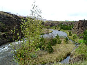
Glerá
River in Iceland
Distance: Approx. 1316 meters
Latitude and longitude: 65.6945,-18.09833333
The Glerá (Icelandic pronunciation: [ˈklɛːrˌauː] , "glass river") is a river in northern Iceland. It originates from glaciers in the mountains of the Tröllaskagi peninsula and also draws from some freshwater springs on its way down Glerá Valley. It runs through the town of Akureyri before it flows into the sea in Eyjafjörður.

Akureyri Junior College
Public school
Distance: Approx. 836 meters
Latitude and longitude: 65.6765,-18.0944
The Akureyri Junior College (Icelandic: Menntaskólinn á Akureyri [ˈmɛn̥taˌskouːlɪn au ˈaːkʏrˌeiːrɪ], regionally also [ˈmɛntʰa-, ˈaːkʰʏr-]; Latin: Schola Akureyrensis) is an Icelandic gymnasium (academic secondary school). It is one of the oldest educational institutions in Iceland. The Menntaskólinn á Akureyri traces its roots to the ancient school in Hólar in Hjaltadalur valley, founded in the beginning of Jón Ögmundsson's episcopacy in 1130.
Akureyrarvöllur
Distance: Approx. 445 meters
Latitude and longitude: 65.68608333,-18.09521111
Akureyrarvöllur (Icelandic pronunciation: [ˈaːkʏrˌeiːrarˌvœtlʏr̥], regionally also [ˈaːkʰʏr-]) is a multi-use stadium in Akureyri, Iceland. It is currently used mostly for football matches and is the former home stadium of Knattspyrnufélag Akureyrar. The stadium holds 1,645 spectators (715 seated).

Northeastern Region (Iceland)
Region of Iceland
Distance: Approx. 560 meters
Latitude and longitude: 65.68333333,-18.1
Northeastern Region (Icelandic: Norðurland eystra pronounced [ˈnɔrðʏrˌlant ˈeistra] ) is one of the traditional eight regions of Iceland, located in the north of the island. The biggest town in the region is Akureyri, with a population of 19,219 in 2021.

Akureyrarkirkja
Church building in Akureyri, Iceland
Distance: Approx. 424 meters
Latitude and longitude: 65.6799,-18.0908
Akureyrarkirkja (Icelandic pronunciation: [ˈaːkʏrˌeiːrarˌcʰɪr̥ca], regionally also [ˈaːkʰʏr-]) or The Church of Akureyri is a prominent Lutheran church at Akureyri in northern Iceland. Located in the centre of the city, it was designed by Guðjón Samúelsson (1887–1950) and completed in 1940. Akureyrarkirkja contains a notably large 3200-pipe organ.

Akureyri Art Museum
Art museum in Akureyri, Iceland
Distance: Approx. 393 meters
Latitude and longitude: 65.6804,-18.0919
The Akureyri Art Museum (Icelandic: Listasafnið á Akureyri [ˈlɪstaˌsapnɪð au ˈaːkʏrˌeiːrɪ], regionally also [ˈaːkʰʏr-]) was founded in 1993. The museum is located in the center of Akureyri, the second-largest city in Iceland. Originally home to a dairy, the building which houses the gallery is noted as a good example of the Bauhaus school of architecture.
Þórsvöllur
Football stadium in Iceland
Distance: Approx. 1631 meters
Latitude and longitude: 65.69138889,-18.11777778
Þórsvöllur (Icelandic pronunciation: [ˈθour̥sˌvœtlʏr̥]) is a football stadium in Iceland. It is located in Akureyri, and seats 984 individuals in one stand but the field can hold 2,000 standing spectators additionally. It is the home stadium for Icelandic football team Þór.
Akureyri Botanical Garden
Botanical garden in Akureyri, Iceland
Distance: Approx. 980 meters
Latitude and longitude: 65.675,-18.09333333
The Akureyri Botanical Garden (Icelandic: Lystigarður Akureyrar [ˈlɪstiˌkarðʏr ˈaːkʏrˌeiːrar̥], regionally also [-ˈaːkʰʏr-]) is located on the west side of the inland end of the fjord Eyjafjörður at about 45 metres elevation. It is located in the southern part of the city of Akureyri in Northern Iceland, 50 kilometres south of the Arctic Circle. It is one of the northernmost botanical gardens in the world.
St. Peter's Church, Akureyri
Church in Akureyri, Iceland
Distance: Approx. 692 meters
Latitude and longitude: 65.677567,-18.092298
St. Peter's Church (Icelandic: St. Péturskirkja) is a religious building of the Catholic Church which is located in Eyrarlandsvegi 26, in the town of Akureyri, Norduland Eystra (Northeast Region) in Iceland, and named after Saint Peter.

Iceland's Bell (sculpture)
Public sculpture
Distance: Approx. 1514 meters
Latitude and longitude: 65.685916,-18.120306
Iceland's Bell or The Iceland Clock (Icelandic: Íslandsklukkan) is an outdoor art piece by Kristin E. Hrafnsson at the University of Akureyri in northern Iceland. It was commissioned by the city of Akureyri and it references the "vigilance that characterizes good university people". The artwork was Hrafnsson's contribution to a competition held by the city of Akureyri in 2000 to commemorate the millennium advent of Christianity in Iceland and Leif Erikson's first colonization of North America.
Weather in this IP's area
broken clouds
15 Celsius
14 Celsius
15 Celsius
15 Celsius
1001 hPa
67 %
1001 hPa
1000 hPa
10000 meters
3.6 m/s
160 degree
75 %
03:48:38
22:48:49