Country:
 Iceland
Region:
City:
Latitude and Longitude:
Time Zone:
Postal Code:
IP information under different IP Channel
ip-api
Country
Region
City
ASN
Time Zone
ISP
Blacklist
Proxy
Latitude
Longitude
Postal
Route
IPinfo
Country
Region
City
ASN
Time Zone
ISP
Blacklist
Proxy
Latitude
Longitude
Postal
Route
MaxMind
Country
Region
City
ASN
Time Zone
ISP
Blacklist
Proxy
Latitude
Longitude
Postal
Route
Luminati
Country
ISASN
Time Zone
Atlantic/Reykjavik
ISP
Ljosleidarinn ehf
Latitude
Longitude
Postal
db-ip
Country
Region
City
ASN
Time Zone
ISP
Blacklist
Proxy
Latitude
Longitude
Postal
Route
ipdata
Country
Region
City
ASN
Time Zone
ISP
Blacklist
Proxy
Latitude
Longitude
Postal
Route
Popular places and events near this IP address

Keflavík
Town in South Constituency, Iceland
Distance: Approx. 4726 meters
Latitude and longitude: 64.01666667,-22.56666667
Keflavík (pronounced [ˈcʰɛplaˌviːk] , meaning Driftwood Bay) is a town in the Reykjanes region in southwest Iceland. It is included in the municipality of Reykjanesbær whose population as of 2016 is 15,129. In 1995, Keflavík merged with nearby Njarðvík and Hafnir to form the municipality of Reykjanesbær.

Keflavík International Airport
Largest airport serving Reykjavík, Iceland
Distance: Approx. 4470 meters
Latitude and longitude: 63.985,-22.60555556
Keflavík Airport (Icelandic: Keflavíkurflugvöllur [ˈcʰɛplaˌviːkʏrˌflʏɣˌvœtlʏr̥]) (IATA: KEF, ICAO: BIKF), also known as Reykjavík–Keflavík Airport, is the largest airport in Iceland and the country's main hub for international transportation. The airport is 1.7 nautical miles (3.1 kilometres) west of Keflavík and 50 km (30 mi) southwest of Reykjavík. The airport has three runways, two of which are in use, and the airport area is about 25 km2 (10 sq mi).

Naval Air Station Keflavik
U.S. Navy base at Keflavik Airport, Iceland
Distance: Approx. 4470 meters
Latitude and longitude: 63.985,-22.60555556
Naval Air Station Keflavik (NASKEF) is a United States Navy air station at Keflavík International Airport, Iceland, located on the Reykjanes peninsula on the south-west portion of the island. NASKEF was closed on 8 September 2006, and its facilities were taken over by the Icelandic Defence Agency as their primary base until 1 January 2011, when the Agency was abolished and the base handed over to the Icelandic Coast Guard, which has operated the base until 2017. US forces returned to Keflavik in 2016, renovating parts of the base to accommodate P-8As on short duration/expeditionary detachments.
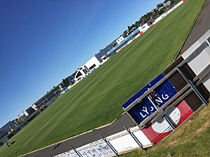
Keflavíkurvöllur
Multi-use stadium in Iceland
Distance: Approx. 2896 meters
Latitude and longitude: 63.997997,-22.559224
Keflavíkurvöllur (Icelandic pronunciation: [ˈcʰɛplaˌviːkʏrˌvœtlʏr̥]) is a multi-use stadium in Keflavík, Iceland. It is currently used mostly for football matches. Keflavík Football Club plays there.

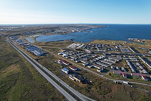
Ásbrú
Distance: Approx. 3481 meters
Latitude and longitude: 63.9675,-22.57888889
Ásbrú (Icelandic pronunciation: [ˈauːsˌpruː]) is a part of the former U.S. Naval Air Station Keflavik not supervised by the Icelandic defence authorities. After U.S. forces evacuated in 2006, a part of the base not needed for current military defence needs, was re-invented as a community of entrepreneurs, students and business. Ásbrú offers academic programs at Keilir, has the largest university campus in Iceland, one of the largest business incubators in Iceland, as well as many other projects such as Iceland’s first international Data center.
Keilir (educational institution)
Distance: Approx. 3049 meters
Latitude and longitude: 63.96861111,-22.57027778
Keilir – Atlantic Centre of Excellence (Icelandic: Keilir, miðstöð vísinda, fræða og atvinnulífs) is a private, non-profit, international educational institution located in Ásbrú next to Keflavik International Airport in the city of Reykjanesbaer in Iceland. The school was established in 2007. The school is owned by the University of Iceland and Icelandic companies.
Njarðvík
Town in South Constituency, Iceland
Distance: Approx. 1755 meters
Latitude and longitude: 63.98333333,-22.55
Njarðvík (Icelandic pronunciation: [ˈnjarðˌviːk]) is a town in southwestern Iceland, on the peninsula of Reykjanes. As of 2009, its population was 4,400.

Viking World museum
Location
Distance: Approx. 872 meters
Latitude and longitude: 63.97602,-22.528469
Viking World (Icelandic: Víkingaheimar [ˈviːciŋkaˌheiːmar̥]) is a museum in Njarðvík, Reykjanesbær, Iceland. The museum opened on 8 May 2009, followed by a formal opening on Icelandic National Day, 17 June. The director was Elisabeth Ward; the building was designed by Guðmundur Jónsson.

Uppspretta
Toyist artwork in Keflavík, Iceland
Distance: Approx. 3377 meters
Latitude and longitude: 63.999547,-22.569056
Uppspretta is the name of a Toyist artwork situated in the Icelandic town of Keflavík. In 2013, a neglected water tower being nine meters in height and thirty-six meters in circumference, was transformed into an object of art. The painting shows the story of a puffin named Uppspretta.
The Icelandic Museum of Rock 'n' Roll
Music museum in Reykjanesbær, Iceland
Distance: Approx. 1980 meters
Latitude and longitude: 63.98972222,-22.54972222
The Icelandic Museum of Rock 'n' Roll (Icelandic: Rokksafn Íslands [ˈrɔhkˌsapn ˈistlan(t)s]) is located at the Hljómahöll concert and conference hall in Reykjanesbær. It was formally opened on April 5, 2014. The museum portrays the history of Icelandic pop and rock music from 1830 to the present.
St. John Paul II Church
Church in Keflavík, Iceland
Distance: Approx. 3050 meters
Latitude and longitude: 63.969813,-22.571594
The St. John Paul II Church (Icelandic: Kirkja St. Jóhannesar Páls II), is the name given to a Roman Catholic church building, located in Keilisvegi 775, in the town of Keflavik, Sudurnes (South Peninsula) in Iceland.
Njarðtaksvöllurinn
Distance: Approx. 2607 meters
Latitude and longitude: 63.9906,-22.5631
Njarðtaksvöllurinn is a multi-use stadium in Njarðvík, Iceland. It is currently used mostly for football matches and is the home stadium of Njarðvík FC. Its capacity is around 1400.
Weather in this IP's area
light rain
10 Celsius
10 Celsius
10 Celsius
12 Celsius
1000 hPa
93 %
1000 hPa
1000 hPa
10000 meters
8.23 m/s
170 degree
75 %
04:24:03
22:48:50