Country:
 Russian Federation
Region:
City:
Latitude and Longitude:
Time Zone:
Postal Code:
IP information under different IP Channel
ip-api
Country
Region
City
ASN
Time Zone
ISP
Blacklist
Proxy
Latitude
Longitude
Postal
Route
IPinfo
Country
Region
City
ASN
Time Zone
ISP
Blacklist
Proxy
Latitude
Longitude
Postal
Route
MaxMind
Country
Region
City
ASN
Time Zone
ISP
Blacklist
Proxy
Latitude
Longitude
Postal
Route
Luminati
Country
RUASN
Time Zone
Europe/Moscow
ISP
Joint Stock Company TransTeleCom
Latitude
Longitude
Postal
db-ip
Country
Region
City
ASN
Time Zone
ISP
Blacklist
Proxy
Latitude
Longitude
Postal
Route
ipdata
Country
Region
City
ASN
Time Zone
ISP
Blacklist
Proxy
Latitude
Longitude
Postal
Route
Popular places and events near this IP address

Irkutsk
City in Irkutsk Oblast, Russia
Distance: Approx. 1840 meters
Latitude and longitude: 52.28333333,104.28333333
Irkutsk ( eer-KOOTSK; Russian: Иркутск, IPA: [ɪrˈkutsk]; Buryat and Mongolian: Эрхүү, Erhüü, [ɛrˈxuː]) is the largest city and administrative center of Irkutsk Oblast, Russia. With a population of 617,473 as of the 2010 Census, Irkutsk is the 25th-largest city in Russia by population, the fifth-largest in the Siberian Federal District, and one of the largest cities in Siberia. Located in the south of the eponymous oblast, the city proper lies on the Angara River, a tributary of the Yenisei, about 850 kilometres (530 mi) to the south-east of Krasnoyarsk and about 520 kilometres (320 mi) north of Ulaanbaatar.

Irkut (river)
River in Russia
Distance: Approx. 1634 meters
Latitude and longitude: 52.2907,104.2754
The Irkut (Russian: Ирку́т; Buryat and Mongolian: Эрхүү гол, Erhüü gol) is a river in the Buryat Republic and Irkutsk Oblast of Russia. It is a left tributary of the Angara. It flows out of lake Ilchir which is situated 50 km away from the highest peak of the Eastern Sayan Mountains, Munku-Sardyk.

Irkutsk State University
University in Irkutsk
Distance: Approx. 2662 meters
Latitude and longitude: 52.2767,104.278
Irkutsk State University (Russian: Ирку́тский госуда́рственный университе́т) was founded in October 1918 in Irkutsk, Siberia. Nowadays Irkutsk State University is a scientific and educational institution training students in humanities, natural, technical and applied sciences. ISU facilities include 8 educational institutions, 11 faculties, the scientific library that is one of the largest University libraries in Russia.

Irkutsk State Linguistic University
Former public university in Irkutsk, Russia
Distance: Approx. 1585 meters
Latitude and longitude: 52.28861111,104.27861111
Irkutsk State Linguistic University (Russian: Иркутский государственный лингвистический университет (ИГЛУ)) was a university in Irkutsk, Siberia in eastern Russia founded in 1948. In 2016, it was integrated into Irkutsk State University as the newly created Institute of Philology, Foreign Languages and Media Communication . The university consists of two institutes (Institute of Cross-cultural Communication and Institute of Educational Technologies) and two independent faculties (Social Sciences Faculty and Education-by-Correspondence Faculty).

Yunosti Island
Distance: Approx. 1629 meters
Latitude and longitude: 52.28333333,104.3
Ostrov Yunosti (Russian: Остров Юности) is a river island in the center of the city of Irkutsk, Russia. This island is covered with woodland and is a popular place for walking. Other attractions include cafes and discos.

Trud Stadium (Irkutsk)
Sports venue in Irkutsk, Russia
Distance: Approx. 2600 meters
Latitude and longitude: 52.27611111,104.28222222
Trud Stadium (Russian: Стадион Труд) is a multi-use stadium in Irkutsk, Russia. It is currently used mostly for football and bandy matches and it is home to FC Zenit Irkutsk. It was the main venue of the 2014 Bandy World Championship.
Pedagogical Institute of Irkutsk State University
Distance: Approx. 901 meters
Latitude and longitude: 52.2925,104.28638889
The Pedagogical Institute of Irkutsk State University (Russian: Педагоги́ческий институ́т Ирку́тского госуда́рственного университе́та) was founded in 1909 in Irkutsk, Siberia as Irkutsk Teaching Institute for training teachers for schools and colleges. The institute has 3 faculties and 21 departments, and provides education in 9 training directions. Minor plant 2585 Irpedina, discovered by Soviet astronomer and a graduate of the Institute Nikolay Chernykh, is named after the institute (Chernykh's wife, Lyudmila Chernykh, was also an astronomer and a graduate of the institute).

Baykalsky State University of Economics and Law
Distance: Approx. 2127 meters
Latitude and longitude: 52.2806,104.2828
Baikal State University (BSU), also known as Baikal National University of Economics and Law, is a Russian state university in Siberia. It was founded in 1930.

Irkutsky District
District in Irkutsk Oblast, Russia
Distance: Approx. 1629 meters
Latitude and longitude: 52.28333333,104.3
Irkutsky District (Russian: Ирку́тский райо́н) is an administrative district, one of the thirty-three in Irkutsk Oblast, Russia. Municipally, it is incorporated as Irkutsky Municipal District. It is located in the south of the oblast.

Irkutsk Governorate
1764–1926 unit of Russia
Distance: Approx. 1633 meters
Latitude and longitude: 52.2833,104.3
Irkutsk Governorate (Russian: Иркутская губерния, romanized: Irkutskaya guberniya) was an administrative-territorial unit (guberniya) of the Russian Empire, located in Siberia. It existed from 1764 to 1926; its seat was in the city of Irkutsk.
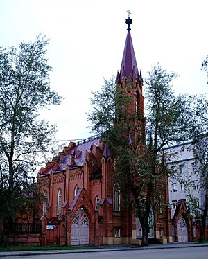
Church of Our Lady of the Assumption, Irkutsk
Church in Irkutsk, Russia
Distance: Approx. 1250 meters
Latitude and longitude: 52.2904,104.2826
The Church of Our Lady of the Assumption (Russian: костёл во имя Успения Пресвятой Девы Марии) also called the Polish Church, it is a Catholic church in Gothic style located in Irkutsk, in Siberia, Russia. A first small wooden church and catholic was built in 1825 in Irkutsk by Catholic settlers. It was enlarged in 1855, but burned down in the great fire of the city in July 1879.
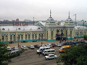
Irkutsk railway station
Railway station in Irkutsk, Russia
Distance: Approx. 2989 meters
Latitude and longitude: 52.283,104.25977778
Irkutsk-Passazhirsky is the primary passenger railway station for the city of Irkutsk in Russia, and an important stop along the Trans-Siberian Railway. The main building takes an area of 7,590 square metres.
Weather in this IP's area
scattered clouds
27 Celsius
28 Celsius
27 Celsius
27 Celsius
1003 hPa
54 %
1003 hPa
956 hPa
10000 meters
6 m/s
310 degree
40 %
05:20:19
20:57:59