Country:
 USA
USARegion:
City:
Latitude and Longitude:
Time Zone:
Postal Code:
IP information under different IP Channel
ip-api
Country
Region
City
ASN
Time Zone
ISP
Blacklist
Proxy
Latitude
Longitude
Postal
Route
IPinfo
Country
Region
City
ASN
Time Zone
ISP
Blacklist
Proxy
Latitude
Longitude
Postal
Route
MaxMind
Country
Region
City
ASN
Time Zone
ISP
Blacklist
Proxy
Latitude
Longitude
Postal
Route
Luminati
Country
USRegion
fl
City
miami
ASN
Time Zone
America/New_York
ISP
Ses Astra S.A.
Latitude
Longitude
Postal
db-ip
Country
Region
City
ASN
Time Zone
ISP
Blacklist
Proxy
Latitude
Longitude
Postal
Route
ipdata
Country
Region
City
ASN
Time Zone
ISP
Blacklist
Proxy
Latitude
Longitude
Postal
Route
Popular places and events near this IP address

Las Olas Boulevard
Road in Fort Lauderdale, Florida
Distance: Approx. 1507 meters
Latitude and longitude: 26.1193,-80.13496
Las Olas Boulevard is a major east-west thoroughfare in Fort Lauderdale, Florida, United States that runs from SW 1st Avenue in the Central Business District to Florida State Road A1A in Fort Lauderdale Beach. The name "Las Olas" means "The Waves" in Spanish. The road once carried the designations of State Road A1A Alt.
Parker Playhouse
Distance: Approx. 502 meters
Latitude and longitude: 26.1342944,-80.1362103
The Parker Playhouse is a 1,147-seat theatre in southern Florida. The Playhouse was established by Dr. Louis Parker.
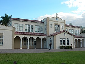
St. Anthony School (Florida)
United States historic place
Distance: Approx. 969 meters
Latitude and longitude: 26.12387222,-80.13286111
St. Anthony Catholic School is a historic school in Fort Lauderdale, Florida. It is located at 820 Northeast 3rd Street.

One Financial Plaza (Fort Lauderdale)
Office in Florida,States
Distance: Approx. 1469 meters
Latitude and longitude: 26.12166667,-80.14
One Financial Plaza is a 374 ft (114 m), 28-story building in downtown Fort Lauderdale, Florida, USA, was opened in 1972. At the time of its opening, it was the tallest building in the Fort Lauderdale area. It has since been surpassed by several buildings.
Stonewall National Museum and Archives
Distance: Approx. 491 meters
Latitude and longitude: 26.1367,-80.1301
Stonewall National Museum and Archives (SNMA, officially Stonewall Library & Archives Inc.) is a nonprofit, tax-exempt 501(c)(3) organization in Fort Lauderdale, Florida that promotes understanding through preserving, interpreting and sharing the culture of lesbian, gay, bisexual and transgender people and their role in society. It owns and manages a library and archival collection and presents a series of public programs. SNMA has two small exhibition areas (Ross Gallery and Hester Gallery) with changing exhibitions drawn primarily from its collections.
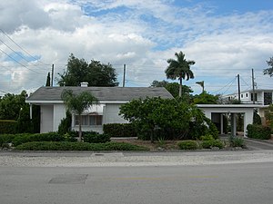
Alfred and Olive Thorpe Lustron House
Historic house in Florida, United States
Distance: Approx. 913 meters
Latitude and longitude: 26.12444444,-80.13333333
The Alfred and Olive Thorpe Lustron House is a historic Lustron house built in 1950, located at 1001 Northeast 2nd Street in Fort Lauderdale, Florida.
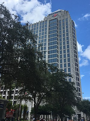
Bank of America Plaza (Fort Lauderdale)
Office in Florida, United States
Distance: Approx. 1596 meters
Latitude and longitude: 26.119782,-80.13898
Bank of America Plaza is a 365 feet (111 m), 23-story office building located at Las Olas City Centre in downtown Fort Lauderdale, Florida. The structure was finished in early 2003, and contains a parking garage which is located on the second to sixth floors, a small retail mall, and a Bank of America—the building's namesake tenant—on the ground floor. It is currently the fifth tallest building in Ft.

PNC Center (Fort Lauderdale)
Office in Florida, United States
Distance: Approx. 1502 meters
Latitude and longitude: 26.1219,-80.1409
PNC Center is a high-rise located in downtown Fort Lauderdale, Florida. The building opened in 1991, as First Union Center and later renamed Wachovia Center, after Wachovia became the building's largest tenant.
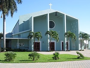
All Saints Episcopal Church (Fort Lauderdale, Florida)
Church in Fort Lauderdale, Florida
Distance: Approx. 1547 meters
Latitude and longitude: 26.1187,-80.1298
All Saints Episcopal Church is a parish of the Episcopal Diocese of Southeast Florida founded in the year 1912.
Bridgescape
Distance: Approx. 1608 meters
Latitude and longitude: 26.1224,-80.1431
Bridgescape, formerly known as EdisonLearning, is an operator of alternative schools, sometimes referred to as dropout recovery schools, in the U.S. According to a ProPublica report, by 2013, Bridgescape operated 17 schools in six states including "options" schools in Chicago, Illinois. Bridgescape cut or left unfilled 40% of its staff positions in 2018. These were positions as career counsellors, teachers, social workers and college counsellors.
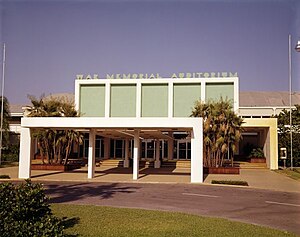
FTL War Memorial
Multi-purpose indoor venue in Fort Lauderdale, Florida
Distance: Approx. 269 meters
Latitude and longitude: 26.13354039,-80.13402431
FTL War Memorial is a 3,400-seat multi-purpose arena, convention center, and ice hockey and skating complex a in Fort Lauderdale, Florida, U.S. The venue hosted professional wrestling cards from the Championship Wrestling from Florida promotion between 1951 and 1987. It was later home to television tapings for Ladies Major League Wrestling in 1990 and UWF Fury Hour in 1991. It was also host to ECW Hardcore Heaven in 1997, MLW WarGames in 2003, ROH Showdown in the Sun in 2012, and MLW WarGames in 2018.
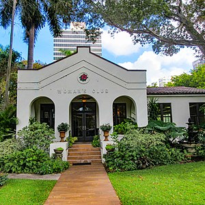
Fort Lauderdale Woman's Club
Historic women's club in Florida
Distance: Approx. 1682 meters
Latitude and longitude: 26.12166667,-80.14333333
The Fort Lauderdale Woman's Club is a women's club in downtown Fort Lauderdale, Florida. They completed their clubhouse building in 1917 which the National Register of Historic Places listed in 2019 as part of a Multiple Property Submission.
Weather in this IP's area
few clouds
27 Celsius
27 Celsius
26 Celsius
28 Celsius
1016 hPa
87 %
1016 hPa
1016 hPa
10000 meters
20 %
06:43:54
20:09:56