Country:
 USA
USARegion:
City:
Latitude and Longitude:
Time Zone:
Postal Code:
IP information under different IP Channel
ip-api
Country
Region
City
ASN
Time Zone
ISP
Blacklist
Proxy
Latitude
Longitude
Postal
Route
IPinfo
Country
Region
City
ASN
Time Zone
ISP
Blacklist
Proxy
Latitude
Longitude
Postal
Route
MaxMind
Country
Region
City
ASN
Time Zone
ISP
Blacklist
Proxy
Latitude
Longitude
Postal
Route
Luminati
Country
USRegion
fl
City
miami
ASN
Time Zone
America/New_York
ISP
Ses Astra S.A.
Latitude
Longitude
Postal
db-ip
Country
Region
City
ASN
Time Zone
ISP
Blacklist
Proxy
Latitude
Longitude
Postal
Route
ipdata
Country
Region
City
ASN
Time Zone
ISP
Blacklist
Proxy
Latitude
Longitude
Postal
Route
Popular places and events near this IP address
Nokesville, Virginia
Census-designated place in Virginia, United States
Distance: Approx. 4227 meters
Latitude and longitude: 38.69833333,-77.57361111
Nokesville is a census-designated place (CDP) in Prince William County, Virginia, United States and Fauquier County, Virginia, United States. The population was 1,619 in the 2020 census.

Manassas Station Operations
Distance: Approx. 1301 meters
Latitude and longitude: 38.7322,-77.5453
The Manassas Station Operations included the operations known as Bristoe Station, Kettle Run, Bull Run Bridge, or Union Mills. It took place August 25–27, 1862, in Prince William County, Virginia, as part of the Northern Virginia Campaign of the American Civil War. On the evening of August 26, after passing around Union Maj.

Battle of Bristoe Station
1863 battle of the American Civil War
Distance: Approx. 474 meters
Latitude and longitude: 38.7234,-77.5418
The Battle of Bristoe Station was fought on October 14, 1863, at Bristoe Station, Virginia, between Union forces under Maj. Gen. Gouverneur K. Warren and Confederate forces under Lt.
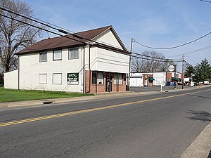
Bristow, Virginia
Unincorporated community in Virginia, United States
Distance: Approx. 25 meters
Latitude and longitude: 38.72277778,-77.53611111
Bristow is an unincorporated community of Prince William County about 30 miles (48 km) from Washington, D.C. It is situated between Manassas, Virginia and Gainesville, Virginia . As of 2014 the total population was 29,346, a 287% increase since 2000. The Bristow community is formally included in the Linton Hall, Virginia census-designated place (CDP) Bristow is home to Jiffy Lube Live outdoor concert stage which was formerly known as the Nissan Pavilion Bristow was voted "Best Place for Homeownership in Virginia" by the Nerd Wallet.
Linton Hall School
Private, day school in Bristow, Virginia, United States
Distance: Approx. 4222 meters
Latitude and longitude: 38.75113889,-77.56872222
Linton Hall School is a Catholic coeducational day-school occupying a 120‑acre campus in Bristow, Virginia, in Prince William County about 60 km (37 mi) west of Washington, D.C. It is located within the Roman Catholic Diocese of Arlington.

Broad Run station
VRE station in Prince William County, Virginia
Distance: Approx. 1179 meters
Latitude and longitude: 38.72944444,-77.52583333
Broad Run is the terminal station for Virginia Railway Express' Manassas Line. It is located at 10637 Piper Lane in the Bristow section of unincorporated Prince William County, Virginia, United States, adjacent to Manassas Regional Airport. It has parking for 885 cars.
Patriot High School (Virginia)
Public school in Nokesville, , Virginia, United States
Distance: Approx. 3850 meters
Latitude and longitude: 38.72583333,-77.58055556
The school is located at 10504 Kettle Run Road, Nokesville, Virginia. The school opened in September 2011. Originally simply "High School #11," Kettle Run High School was the working name of the new high school in the western portion of Prince William County, Virginia that was completed in September 2011.
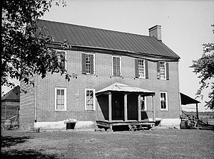
Moor Green
Historic house in Virginia, United States
Distance: Approx. 3841 meters
Latitude and longitude: 38.70722222,-77.49694444
Moor Green is a historic home located near Brentsville, Prince William County, Virginia. It dates to the early-19th century, and is a two-story, five-bay, Federal style brick residence, with a one-room, two-story ell. It has a standing seam metal gable roof and a single-pile, central-passage plan.
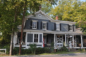
Davis–Beard House
Historic house in Virginia, United States
Distance: Approx. 112 meters
Latitude and longitude: 38.72333333,-77.5375
Davis–Beard House, also known as Glee Hall and Davis House, is a historic home located at Bristow, Prince William County, Virginia. It was built after the American Civil War, and is a two-story, five-bay, frame dwelling with later additions. The rambling dwelling has a number of Late Victorian style decorative elements.
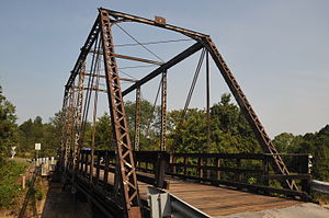
Nokesville Truss Bridge
United States historic place
Distance: Approx. 2970 meters
Latitude and longitude: 38.70722222,-77.56416667
Nokesville Truss Bridge is a historic Pratt truss bridge carrying Virginia State Route 646 (Aden Road) across the Norfolk Southern Railway near Nokesville, Prince William County, Virginia. It was built in 1882 by the Keystone Bridge Company. The single-span bridge measures 73 feet 11.5 inches (22.543 m) long, and is constructed of wrought iron.

Cannon Branch Fort
United States historic place
Distance: Approx. 2255 meters
Latitude and longitude: 38.736076,-77.516788
The Cannon Branch Fort is a historic American Civil War fortification at 10611 Gateway Boulevard in Manassas, Virginia. Details of the exact time and circumstances of its construction are not known; it is believed to have been built by Union Army forces in 1863 or 1864 to defend the nearby railroad lines. The site was listed on the National Register of Historic Places in 1999.
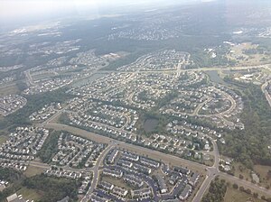
Innovation, Virginia
Census-designated place in Virginia, United States
Distance: Approx. 3762 meters
Latitude and longitude: 38.75416667,-77.52027778
Innovation is an unincorporated area and census-designated place (CDP) in Prince William County, Virginia, United States. As of the 2020 census, it had a population of 926. The CDP is in the central part of the county, bordered to the southeast by the independent city of Manassas.
Weather in this IP's area
clear sky
17 Celsius
17 Celsius
16 Celsius
19 Celsius
1020 hPa
83 %
1020 hPa
1013 hPa
10000 meters
06:07:29
20:25:34