Country:
 Switzerland
Region:
City:
Latitude and Longitude:
Time Zone:
Postal Code:
IP information under different IP Channel
ip-api
Country
Region
City
ASN
Time Zone
ISP
Blacklist
Proxy
Latitude
Longitude
Postal
Route
IPinfo
Country
Region
City
ASN
Time Zone
ISP
Blacklist
Proxy
Latitude
Longitude
Postal
Route
MaxMind
Country
Region
City
ASN
Time Zone
ISP
Blacklist
Proxy
Latitude
Longitude
Postal
Route
Luminati
Country
CHASN
Time Zone
Europe/Zurich
ISP
netplus.ch SA
Latitude
Longitude
Postal
db-ip
Country
Region
City
ASN
Time Zone
ISP
Blacklist
Proxy
Latitude
Longitude
Postal
Route
ipdata
Country
Region
City
ASN
Time Zone
ISP
Blacklist
Proxy
Latitude
Longitude
Postal
Route
Popular places and events near this IP address

Trient Hut
Mountain hut in the Swiss alps
Distance: Approx. 2888 meters
Latitude and longitude: 45.999,7.044
The Trient hut (French: Cabane du Trient) is a mountain hut in the Swiss Alps, near the Swiss town of Martigny and the French town of Chamonix. The hut sits at an altitude of 3,170 m (10,400 ft), on a rock perched above the Trient Glacier. It can be reached on foot by mountaineers and strong hikers with experience of glacier travel.

Albert Premier Hut
Mountain hut located on the Haute Route between Chamonix, France and Zermatt, Switzerland
Distance: Approx. 3308 meters
Latitude and longitude: 45.996,6.986
The Albert Premier Hut (French: refuge Albert-Ier ), sometimes known as Albert 1er, is located on the Haute Route between Chamonix, France and Zermatt, Switzerland. It is at 2,702 metres (8,865 ft) above sea level. It is a popular hut with day hikers because of the short hike (2 to 3 hours) and views of Chamonix Valley.
Pointe d'Orny
Mountain of the Mont Blanc massif
Distance: Approx. 2584 meters
Latitude and longitude: 46.00213889,7.04272222
The Pointe d'Orny (3,271 m) is a mountain of the Mont Blanc massif, located west of Orsières in the canton of Valais. It lies north-east of the Plateau du Trient. Below the summit lies the Cabane du Trient, a mountain hut operated by the Swiss Alpine Club.
Aiguille du Tour
Mountain in the Mont Blanc massif
Distance: Approx. 2537 meters
Latitude and longitude: 45.99441667,7.00983333
The Aiguille du Tour (3,540 metres (11,614 ft)) is a mountain in the Mont Blanc massif, located on the border between Switzerland and France. The voie normale on the mountain is graded F (facile) and can be climbed from either the Albert Premier Hut on the French side or the Trient Hut on the Swiss side. The Aiguille du Pissoir (3,440 m) and the Aiguille Purtscheller (3,475 m) are secondary summits located respectively north and south of the Aiguille du Tour.
Pointe des Grands
Mountain in Switzerland
Distance: Approx. 2564 meters
Latitude and longitude: 46.00325,6.98977778
The Pointe des Grands is a mountain of the Mont Blanc Massif, located on the border between France and Switzerland, north-west of the Aiguille du Tour. The mountain overlooks the Glacier des Grands on its (Swiss) northern side.
Pointe des Berons
Mountain of the Mont Blanc Massif
Distance: Approx. 2758 meters
Latitude and longitude: 46.00611111,6.98444444
The Pointe des Berons is a mountain of the Mont Blanc Massif, located on the border between Switzerland and France. It lies approximately halfway between the Col de Balme and the Aiguille du Tour. The east (Swiss) side is covered by the Glacier des Berons.
Les Grandes Otanes
Mountain in Switzerland
Distance: Approx. 2747 meters
Latitude and longitude: 46.01944444,6.98138889
Les Grandes Otanes is a mountain of the Mont Blanc Massif, located on the border between Switzerland and France, north of the Aiguille du Tour. They overlook the Col de Balme.
Pointe Ronde
Mountain of the Mont Blanc massif
Distance: Approx. 2699 meters
Latitude and longitude: 46.04083333,7.02
The Pointe Ronde is a mountain of the Mont Blanc massif, overlooking Trient in the canton of Valais. It lies near the northern end of the Arête de la Lys, the ridge descending in a north-westerly direction from the Génépi towards the Col de la Forclaz.
Le Génépi
Mountain of the Swiss Mont Blanc massif
Distance: Approx. 2303 meters
Latitude and longitude: 46.02472222,7.04416667
Le Génépi (2,884 m) is a mountain of the Swiss Mont Blanc massif, located west of Champex in the canton of Valais. It is the culminating point of the group lying north of the Fenêtre d'Arpette.

Petite Pointe d'Orny
Mountain in Switzerland
Distance: Approx. 1994 meters
Latitude and longitude: 46.00611111,7.0375
The Petite Pointe d'Orny is a mountain of the Mont Blanc Massif, overlooking the Trient Glacier in the canton of Valais. It lies north of the Pointe d'Orny.

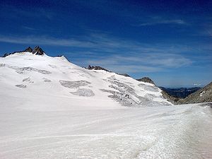
Trient Glacier
Glacier situated in the Mont Blanc Massif
Distance: Approx. 2759 meters
Latitude and longitude: 45.99333333,7.02861111
The Trient Glacier (French: Glacier du Trient) is a 4.3 km long glacier (2007) in the Mont Blanc Massif in the canton of Valais in Switzerland. In 1973 it had an area of 6.4 km². The upper part of the glacier forms a large plateau named Plateau du Trient.
Pointe des Ecandies
Mountain in Switzerland
Distance: Approx. 1769 meters
Latitude and longitude: 46.01511111,7.03947222
The Pointe des Ecandies is a mountain of the Mont Blanc Massif, located between Trient and Champex in the canton of Valais. It is located north of the Pointe d'Orny and east of the Trient Glacier.
Weather in this IP's area
clear sky
8 Celsius
7 Celsius
8 Celsius
10 Celsius
1026 hPa
69 %
1026 hPa
783 hPa
10000 meters
1.96 m/s
1.81 m/s
183 degree
1 %
06:11:00
21:05:35