Country:
 Germany
Region:
City:
Latitude and Longitude:
Time Zone:
Postal Code:
IP information under different IP Channel
ip-api
Country
Region
City
ASN
Time Zone
ISP
Blacklist
Proxy
Latitude
Longitude
Postal
Route
IPinfo
Country
Region
City
ASN
Time Zone
ISP
Blacklist
Proxy
Latitude
Longitude
Postal
Route
MaxMind
Country
Region
City
ASN
Time Zone
ISP
Blacklist
Proxy
Latitude
Longitude
Postal
Route
Luminati
Country
DERegion
by
City
sonthofen
ASN
Time Zone
Europe/Berlin
ISP
IDKOM Networks GmbH
Latitude
Longitude
Postal
db-ip
Country
Region
City
ASN
Time Zone
ISP
Blacklist
Proxy
Latitude
Longitude
Postal
Route
ipdata
Country
Region
City
ASN
Time Zone
ISP
Blacklist
Proxy
Latitude
Longitude
Postal
Route
Popular places and events near this IP address

Rüdesheim am Rhein
Town in Hesse, Germany
Distance: Approx. 1843 meters
Latitude and longitude: 49.98333333,7.93055556
Rüdesheim am Rhein is a German winemaking town in the Rhine Gorge, and part of the UNESCO World Heritage Site in this region. It lies in the Rheingau-Taunus-Kreis district in the Regierungsbezirk of Darmstadt, Hessen. Known as Rüdesheim, it is officially Rüdesheim am Rhein, to distinguish it from Rüdesheim an der Nahe.
Geisenheim Grape Breeding Institute
German research institute
Distance: Approx. 2564 meters
Latitude and longitude: 49.98416667,7.96138889
The Geisenheim Grape Breeding Institute was founded in 1872 and is located in the town of Geisenheim, in Germany's Rheingau region. In 1876 Swiss-born professor Hermann Müller joined the institute, where he developed his namesake grape variety Müller-Thurgau, which became Germany's most-planted grape variety in the 1970s. Professor Helmut Becker worked at the institute from 1964 until his death in 1989.
Eibingen
Distance: Approx. 2126 meters
Latitude and longitude: 49.986,7.931
Eibingen, now a part of Rüdesheim am Rhein, Hesse, Germany is the location of Eibingen Abbey, the Benedictine monastery founded by Hildegard of Bingen in 1165 (replacing an Augustine foundation of 1148). Eibingen preserves the treasure of relics assembled by Hildegard, including the heads of Saint Gudula, Saint Bertha of Bingen, Saint Valerian, and Saint Wipert besides one arm of Saint Rupert of Bingen and Hildegard's own remains. Eibingen was a self-governing community until 1939, when under the secrecy that held sway at the time, it was forcibly amalgamated with the Rüdesheim by the National Socialists, against the community inhabitants' will.

Chapel of St. Roch, Bingen
Distance: Approx. 778 meters
Latitude and longitude: 49.9665,7.9262
The Chapel of St. Roch (German: Rochuskapelle) is a German pilgrimage chapel, dedicated to Saint Roch, located on the Rochusberg southeast of Bingen am Rhein.
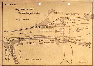
Hindenburg Bridge
Train bridge over the Rhine at Rüdesheim, Germany
Distance: Approx. 823 meters
Latitude and longitude: 49.97388889,7.94222222
The Hindenburg Bridge (German: Hindenburgbrücke) was a railway bridge over the Rhine between Rüdesheim in the German state of Hesse and Bingen-Kempten state of Rhineland-Palatinate, named in 1918 after Field Marshal Paul von Hindenburg, later German President. The bridge was put in service in 1915, destroyed in the Second World War and never rebuilt. Since 2002 the remains of the Hindenburg bridge has been the easternmost point of the UNESCO World Heritage Site of the Upper Middle Rhine Valley.

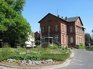
Bingen Technical University of Applied Sciences
Distance: Approx. 1827 meters
Latitude and longitude: 49.95333333,7.92361111
The Bingen Technical University of Applied Sciences (German: Technische Hochschule Bingen) is a university located in Bingen am Rhein, Germany. It was founded in 1897. The University of Applied Sciences Bingen consists of two faculties: the faculty of life sciences and engineering and the faculty of technology, informatics and business.

Rüdesheim (Rhein) station
Distance: Approx. 1877 meters
Latitude and longitude: 49.977054,7.915615
Rüdesheim (Rhein) station is in the town of Rüdesheim am Rhein in the German state of Hesse on the East Rhine Railway (German: Rechte Rheinstrecke). It is on the western edge of the town, separated from the Rhine only by federal highway B 42. The entrance building is a double storey stucco building in a neoclassical style.

Bingen (Rhein) Stadt station
Distance: Approx. 2286 meters
Latitude and longitude: 49.969793,7.905308
Bingen (Rhein) Stadt station (Bingen town station) is, after Bingen Hauptbahnhof, the second largest station in the town of Bingen am Rhein in the German state of Rhineland-Palatinate. The station is located on the West Rhine Railway (German: Linke Rheinstrecke) between Koblenz to Mainz. Furthermore, the station is the beginning and end of the Rheinhessen Railway to/from Worms.
Weingut Dr. Heinrich Nägler
German wine grower and producer
Distance: Approx. 1576 meters
Latitude and longitude: 49.98083333,7.93055556
Weingut Dr. Heinrich Nägler is a German wine grower and producer based in Rüdesheim am Rhein, in the wine-growing region of Rheingau, Germany.
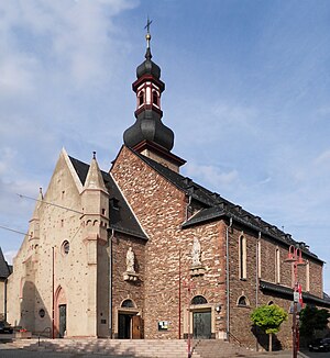
St. Jakobus, Rüdesheim
Church in Hesse, Germany
Distance: Approx. 1623 meters
Latitude and longitude: 49.97923,7.92396
St. Jakobus is a Catholic church and a former parish in Rüdesheim am Rhein, Hesse, Germany. It dates back to the 10th century, was expanded around 1400, and again in 1913/14.
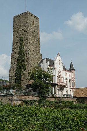
Boosenburg
Castle in Hesse, Germany
Distance: Approx. 1830 meters
Latitude and longitude: 49.97833333,7.91805556
The Boosenburg is a lowland castle in Rüdesheim am Rhein, Rheingau-Taunus-Kreis, Hesse, Germany, located in the Rhine valley and dating back to the 12th century. It is locally known as Oberburg (upper castle) in relation to the near and slightly lower Brömserburg. It has been part of the Rhine Gorge World Heritage Site from 2002.

Brömserburg
Stone castle in Germany
Distance: Approx. 1796 meters
Latitude and longitude: 49.97761389,7.91770278
The Brömserburg (also called the Niederburg) is a castle located near the banks of the Rhine in the town of Rüdesheim am Rhein in Rheingau-Taunus-Kreis in the German state of Hesse. Its original structure was probably one of the first stone castles in the Rhine Gorge, now a UNESCO World Heritage Site.
Weather in this IP's area
moderate rain
20 Celsius
21 Celsius
19 Celsius
21 Celsius
1014 hPa
99 %
1014 hPa
1004 hPa
10000 meters
0.69 m/s
1.16 m/s
160 degree
98 %
05:51:07
21:18:09