Country:
 Germany
Region:
City:
Latitude and Longitude:
Time Zone:
Postal Code:
IP information under different IP Channel
ip-api
Country
Region
City
ASN
Time Zone
ISP
Blacklist
Proxy
Latitude
Longitude
Postal
Route
IPinfo
Country
Region
City
ASN
Time Zone
ISP
Blacklist
Proxy
Latitude
Longitude
Postal
Route
MaxMind
Country
Region
City
ASN
Time Zone
ISP
Blacklist
Proxy
Latitude
Longitude
Postal
Route
Luminati
Country
 LU
LUASN
Time Zone
Europe/Luxembourg
ISP
Ses Astra S.A.
Latitude
Longitude
Postal
db-ip
Country
Region
City
ASN
Time Zone
ISP
Blacklist
Proxy
Latitude
Longitude
Postal
Route
ipdata
Country
Region
City
ASN
Time Zone
ISP
Blacklist
Proxy
Latitude
Longitude
Postal
Route
Popular places and events near this IP address

Kirchen (Sieg)
Town in Rhineland-Palatinate, Germany
Distance: Approx. 2129 meters
Latitude and longitude: 50.80861111,7.88333333
Kirchen (Sieg) is a town and Luftkurort (climatic spa) in the district of Altenkirchen in the north of Rhineland-Palatinate, Germany. It is situated on the river Sieg, approx. 12 km southwest of Siegen.

Heller (river)
River in Germany
Distance: Approx. 172 meters
Latitude and longitude: 50.7894,7.8713
The Heller is a 30 km long river in western Germany. It is a left tributary of the Sieg. The source is located near Haiger in Hesse.

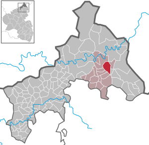
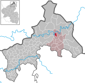
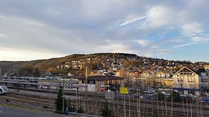
Betzdorf, Germany
Town in Rhineland-Palatinate, Germany
Distance: Approx. 598 meters
Latitude and longitude: 50.78555556,7.87277778
Betzdorf (German pronunciation: [ˈbɛtsdɔʁf]) is a town and municipality in northern Rhineland-Palatinate, Germany. Betzdorf is part of the district of Altenkirchen. Betzdorf is located on the river Sieg, approx.
Alsdorf, Altenkirchen
Municipality in Rhineland-Palatinate, Germany
Distance: Approx. 1768 meters
Latitude and longitude: 50.77666667,7.88305556
Alsdorf is a municipality in the district of Altenkirchen, in Rhineland-Palatinate, Germany.
Scheuerfeld
Municipality in Rhineland-Palatinate, Germany
Distance: Approx. 2263 meters
Latitude and longitude: 50.78722222,7.84027778
Scheuerfeld is a municipality in the district of Altenkirchen, in Rhineland-Palatinate, in western Germany.

Wallmenroth
Municipality in Rhineland-Palatinate, Germany
Distance: Approx. 2418 meters
Latitude and longitude: 50.79694444,7.83888889
Wallmenroth is a municipality in the district of Altenkirchen, in Rhineland-Palatinate, in western Germany. It has a total population of 1,185 as of 2021.
Betzdorf (Verbandsgemeinde)
Verbandsgemeinde in Rhineland-Palatinate
Distance: Approx. 551 meters
Latitude and longitude: 50.786,7.873
Betzdorf is a former Verbandsgemeinde ("collective municipality") in the district of Altenkirchen, in Rhineland-Palatinate, Germany. On 1 January 2017 it merged into the new Verbandsgemeinde Betzdorf-Gebhardshain. The seat of the Verbandsgemeinde was in Betzdorf.

Verbandsgemeinde Kirchen (Sieg)
Verbandsgemeinde in Rhineland-Palatinate, Germany
Distance: Approx. 1994 meters
Latitude and longitude: 50.80777778,7.88138889
Verbandsgemeinde Kirchen (Sieg) is a Verbandsgemeinde ("collective municipality") in the district of Altenkirchen, in Rhineland-Palatinate, Germany. The seat of the Verbandsgemeinde is in Kirchen.

Asdorf
River in Germany
Distance: Approx. 2035 meters
Latitude and longitude: 50.8088,7.8778
Asdorf (also: Asdorfer Bach, in its upper course: Weibe) is a river of North Rhine-Westphalia and Rhineland-Palatinate, Germany. It flows into the Sieg in Kirchen.

Betzdorf-Gebhardshain
Verbandsgemeinde in Rhineland-Palatinate, Germany
Distance: Approx. 394 meters
Latitude and longitude: 50.787738,7.874415
Betzdorf-Gebhardshain is a Verbandsgemeinde ("collective municipality") in the district of Altenkirchen, in Rhineland-Palatinate, Germany. The seat of the Verbandsgemeinde is in Betzdorf. It was formed on 1 January 2017 by the merger of the former Verbandsgemeinden Betzdorf and Gebhardshain.

Betzdorf (Sieg) station
Distance: Approx. 219 meters
Latitude and longitude: 50.789531,7.869667
Betzdorf (Sieg) station is in the town of Betzdorf in the German state of Rhineland-Palatinate. It is on the Sieg Railway (Siegstrecke) and is the starting point of the Betzdorf–Haiger railway to Haiger/Dillenburg and the Betzdorf–Daaden railway to Daaden.
Daade
River in Germany
Distance: Approx. 1792 meters
Latitude and longitude: 50.781774,7.892868
The Daade (also called the Daadenbach) is the largest tributary of the River Heller, in the district of Altenkirchen in the northeast of the German state of Rhineland-Palatinate. It flows through the northeastern part of the Westerwald. It is 16.027 kilometres (9.959 mi) long and has a catchment area of 53.28 km2 (20.57 sq mi).
Weather in this IP's area
broken clouds
20 Celsius
20 Celsius
20 Celsius
22 Celsius
1025 hPa
72 %
1025 hPa
1002 hPa
10000 meters
3.6 m/s
280 degree
75 %
05:49:34
21:20:13