Country:
 France
Region:
City:
Latitude and Longitude:
Time Zone:
Postal Code:
IP information under different IP Channel
ip-api
Country
Region
City
ASN
Time Zone
ISP
Blacklist
Proxy
Latitude
Longitude
Postal
Route
IPinfo
Country
Region
City
ASN
Time Zone
ISP
Blacklist
Proxy
Latitude
Longitude
Postal
Route
MaxMind
Country
Region
City
ASN
Time Zone
ISP
Blacklist
Proxy
Latitude
Longitude
Postal
Route
Luminati
Country
FRASN
Time Zone
Europe/Paris
ISP
Ses Astra S.A.
Latitude
Longitude
Postal
db-ip
Country
Region
City
ASN
Time Zone
ISP
Blacklist
Proxy
Latitude
Longitude
Postal
Route
ipdata
Country
Region
City
ASN
Time Zone
ISP
Blacklist
Proxy
Latitude
Longitude
Postal
Route
Popular places and events near this IP address
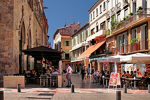
Perpignan
Prefecture and commune in Occitania, France
Distance: Approx. 101 meters
Latitude and longitude: 42.6986,2.8956
Perpignan (UK: , US: , French: [pɛʁpiɲɑ̃] ; Catalan: Perpinyà, [pəɾpiˈɲa]; Occitan: Perpinhan, [peɾpiˈɲa]) is the prefecture of the Pyrénées-Orientales department in Southern France, in the heart of the plain of Roussillon, at the foot of the Pyrenees a few kilometres from the Mediterranean Sea and the scrublands of the Corbières massif. It is the centre of the Perpignan Méditerranée Métropole metropolitan area. In 2016, Perpignan had a population of 121,875 in the commune proper, and the metropolitan area had a total population of 268,577, making it the last major French city before the Spanish border.
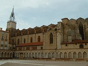
Perpignan Cathedral
Distance: Approx. 339 meters
Latitude and longitude: 42.70055556,2.89694444
The Cathedral of Saint John the Baptist (French: Basilique-Cathédrale de Saint-Jean-Baptiste de Perpignan; Catalan: Catedral de Sant Joan Baptista de Perpinyà) is a Roman Catholic cathedral, and a national monument of France, located in the town of Perpignan in Languedoc-Roussillon. It is dedicated to Saint John the Baptist. Construction of the cathedral was begun in 1324 by King Sancho of Majorca, and later finished in the 15th century.
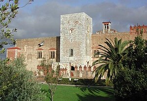
Palace of the Kings of Majorca
Palace in Pyrénées-Orientales, France
Distance: Approx. 424 meters
Latitude and longitude: 42.69388889,2.89555556
The Palace of the Kings of Majorca (French: Palais des Rois de Majorque, Catalan: Palau dels Reis de Mallorca), is a palace and a fortress with gardens overlooking the city of Perpignan in Pyrenees-Orientales, France.
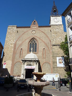
Roman Catholic Diocese of Perpignan-Elne
Catholic diocese in France
Distance: Approx. 318 meters
Latitude and longitude: 42.70055556,2.89555556
The Diocese of Perpignan–Elne (Latin: Dioecesis Elnensis; French: Diocèse de Perpignan–Elne; Catalan: Bisbat de Perpinyà–Elna) is a Latin diocese of the Catholic Church in France. The diocese comprises the Department of Pyrénées-Orientales. This see continues the old Diocese of Elne, which was renamed and had its see relocated at Perpignan, in 1601 after a papal bull of Pope Clement VIII. Its territory brought together the Diocese of Elne, part of the Spanish Diocese of Urgel known as French Cerdagne, three cantons of the Diocese of Alet, and two villages of the Diocese of Narbonne.
Siege of Perpignan (1542)
1542 battle in which Spain defeated France
Distance: Approx. 101 meters
Latitude and longitude: 42.6986,2.8956
The siege of Perpignan took place in 1542, at Perpignan, between a larger French army commanded by Henry, Dauphin of France and the Spanish garrison at Perpignan. The Spaniards resisted until the arrival of the Spanish army under Don Fernando Álvarez de Toledo, Duke of Alba, causing the withdrawal of the French army. The siege was one of the costliest defeats of Francis I of France in the French offensive of 1542.

Battle of Perpignan
Battle of the War of the First Coalition
Distance: Approx. 101 meters
Latitude and longitude: 42.6986,2.8956
The Battle of Perpignan or Battle of Niel (fr:Bataille de Perpignan) on 17 July 1793 saw the French Army of the Eastern Pyrenees led by Louis-Charles de Flers defending against an offensive by the Spanish Army of Catalonia commanded by Antonio Ricardos. The French turned back the Spanish attacks and forced their opponents to pull back. Perpignan is now the capital of Pyrénées Orientales department, but in 1793 was the chief city of Roussillon province.
Siege of Perpignan (1642)
1641 siege
Distance: Approx. 101 meters
Latitude and longitude: 42.6986,2.8956
The siege of Perpignan was a siege during the Catalan Revolt.
Canton of Perpignan-6
Distance: Approx. 518 meters
Latitude and longitude: 42.7,2.89
The Canton of Perpignan-6 is a French canton of Pyrénées-Orientales department, in Occitanie.
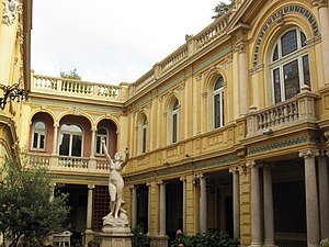
Hôtel Pams
Mansion (Hôtel particulier) in Languedoc-Roussillon, France
Distance: Approx. 231 meters
Latitude and longitude: 42.6979,2.898311
The Hôtel Pams is a mansion in Perpignan, Pyrénées-Orientales, France. It was built between 1852 and 1872 by Pierre Bardou, one of the founders of the JOB cigarette paper company, then transformed in the 1890s into an elegant mansion by his son-in-law Jules Pams, a politician and amateur art-lover. It illustrates the artistic taste of the wealthy bourgeois at the turn of the 20th century.

L'Été sans bras
Sculpture by Aristide Maillol
Distance: Approx. 523 meters
Latitude and longitude: 42.70235478,2.89635658
L’Été sans bras is a sculpture made by Aristide Maillol in 1911.

Perpignan Méditerranée Métropole
Communauté urbaine in Occitania, France
Distance: Approx. 518 meters
Latitude and longitude: 42.7,2.89
The Perpinyà Metròpolis Mediterrani is the communauté urbaine, an intercommunal structure, centred on the city of Perpinyà. It is located in the Pyrénées-Orientales department, in the Occitanie region, southern France. It was created in January 2016, replacing the previous communauté d'agglomération Perpignan Méditerranée.

Castillet
Fortification in Perpignan, France
Distance: Approx. 344 meters
Latitude and longitude: 42.70055556,2.89388889
The Castillet (locally [kəstiˈʎet] or Castellet in Standard Catalan, meaning small castle) is an ancient fortification and city gate located in Perpignan (Pyrénées-Orientales, France). Today, this monument, a strong symbol of the city, has become a museum: Museu Català de les Arts i Tradicions Populars (Catalan Museum of Popular Arts and Traditions). The Castillet was made of three parts: the big Castillet, the small Castillet (former city gate), and a polygonal bastion.
Weather in this IP's area
few clouds
30 Celsius
33 Celsius
30 Celsius
35 Celsius
1013 hPa
64 %
1013 hPa
1008 hPa
10000 meters
6.69 m/s
80 degree
20 %
06:35:08
21:14:28