Country:
 Russian Federation
Region:
City:
Latitude and Longitude:
Time Zone:
Postal Code:
IP information under different IP Channel
ip-api
Country
Region
City
ASN
Time Zone
ISP
Blacklist
Proxy
Latitude
Longitude
Postal
Route
IPinfo
Country
Region
City
ASN
Time Zone
ISP
Blacklist
Proxy
Latitude
Longitude
Postal
Route
MaxMind
Country
Region
City
ASN
Time Zone
ISP
Blacklist
Proxy
Latitude
Longitude
Postal
Route
Luminati
Country
RUASN
Time Zone
Europe/Moscow
ISP
Joint Stock Company TransTeleCom
Latitude
Longitude
Postal
db-ip
Country
Region
City
ASN
Time Zone
ISP
Blacklist
Proxy
Latitude
Longitude
Postal
Route
ipdata
Country
Region
City
ASN
Time Zone
ISP
Blacklist
Proxy
Latitude
Longitude
Postal
Route
Popular places and events near this IP address

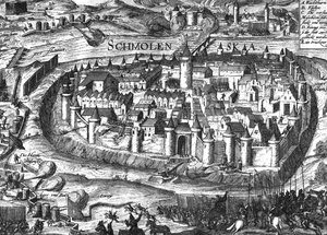
Smolensk
City in Smolensk Oblast, Russia
Distance: Approx. 350 meters
Latitude and longitude: 54.78277778,32.04527778
Smolensk is a city and the administrative center of Smolensk Oblast, Russia, located on the Dnieper River, 360 kilometers (220 mi) west-southwest of Moscow. First mentioned in 863, it is one of the oldest cities in Russia. It has a population of 316,570 (2021 Census).

Smolensk Voivodeship
Voivodeship of the Grand Duchy of Lithuania
Distance: Approx. 350 meters
Latitude and longitude: 54.782778,32.045278
Smolensk Voivodeship (Latin: Palatinatus smolencensis; Belarusian: Смаленскае ваяводзтва; Polish: Województwo smoleńskie; Lithuanian: Smolensko vaivadija; Russian: Смоленское воеводство) was a unit of administrative division and local government in the Grand Duchy of Lithuania and later the Polish–Lithuanian Commonwealth.

Battle of Smolensk (1941)
Battle on the Eastern Front of World War II
Distance: Approx. 350 meters
Latitude and longitude: 54.78277778,32.04527778
The first Battle of Smolensk (German: Kesselschlacht bei Smolensk, lit. 'Cauldron-battle at Smolensk'; Russian: Смоленская стратегическая оборонительная операция, romanized: Smolenskaya strategicheskaya oboronitelnaya operatsiya, lit. 'Smolensk strategic defensive operation') was a battle during the second phase of Operation Barbarossa, the Axis invasion of the Soviet Union, in World War II. It was fought around the city of Smolensk between 10 July and 10 September 1941, about 400 km (250 mi) west of Moscow. The Ostheer had advanced 500 km (310 mi) into the USSR in the 18 days after the invasion on 22 June 1941.

Smolensk Governorate
1796–1929 unit of Russia
Distance: Approx. 352 meters
Latitude and longitude: 54.7828,32.0453
Smolensk Governorate (Russian: Смоленская губерния, romanized: Smolenskaya guberniya) was an administrative-territorial unit (guberniya) of the Tsardom of Russia, the Russian Empire, and the Russian SFSR. It existed, with interruptions, between 1708 and 1929. Smolensk Governorate, together with seven other governorates, was established on December 29 [O.S. December 18], 1708, by an edict from Tsar Peter the Great. As with the rest of the governorates, neither the borders nor internal subdivisions of Smolensk Governorate were defined; instead, the territory was defined as a set of cities, and section of lands adjacent to those cities.
Siege of Smolensk (1609–1611)
1609–1611 siege
Distance: Approx. 658 meters
Latitude and longitude: 54.78333333,32.05
The siege of Smolensk (Polish: oblężenie Smoleńska), also known as the Smolensk Defense in Russia (Russian: Смоленская оборона), lasted 20 months between 29 September 1609 to 13 June 1611, when the Polish army besieged the Russian city of Smolensk during the Polish–Russian War (1609–1618).

Smolensk operation
Recapture of the city by the Soviet 39th, 43rd and 10th Guards armies
Distance: Approx. 658 meters
Latitude and longitude: 54.78333333,32.05
The second Smolensk operation (code naming "Suvorov"; 7 August – 2 October 1943) was a Soviet strategic offensive operation conducted by the Red Army as part of the Summer-Autumn Campaign of 1943. Staged almost simultaneously with the Lower Dnieper Offensive (13 August – 22 September), the offensive lasted two months and was led by General Andrei Yeremenko, commanding the Kalinin Front, and Vasily Sokolovsky, commanding the Western Front. Its goal was to clear the German presence from the Smolensk and Bryansk regions.
Siege of Smolensk (1654)
1654 event
Distance: Approx. 658 meters
Latitude and longitude: 54.78333333,32.05
The siege of Smolensk was one of the first great events of the Russo-Polish War (1654–67). Smolensk, which had been under the rule of the Polish–Lithuanian Commonwealth during 1404–1514 and since 1611, was besieged by a Russian army in June 1654. The Polish garrison of the city (commanded by Smolensk Voivode Filip Obuchowicz) hoped to get reinforcements from the army of Janusz Radziwiłł (1612–1655), stationed in Orsha.
Western Oblast
1929–1937 unit of Russia
Distance: Approx. 658 meters
Latitude and longitude: 54.78333333,32.05
Western Oblast (Russian: Западная область, romanized: Zapadnaya oblast) was an administrative-territorial unit (oblast) of the Russian SFSR from 1929 to 1937. Its seat was in the city of Smolensk. The oblast was located in the west of European Russia, and its territory is currently divided between Bryansk, Kaluga, Pskov, Smolensk, and Tver Oblasts.
Smolensky District, Smolensk Oblast
District in Smolensk Oblast, Russia
Distance: Approx. 658 meters
Latitude and longitude: 54.78333333,32.05
Smolensky District (Russian: Смоле́нский райо́н) is an administrative and municipal district (raion), one of the twenty-five in Smolensk Oblast, Russia. It is located in the west of the oblast and borders with Demidovsky District in the north, Dukhovshchinsky District in the northeast, Kardymovsky District in the east, Pochinkovsky District in the south, Monastyrshchinsky District in the southwest, Krasninsky District in the west, and with Rudnyansky District in the northwest. The area of the district is 2,494.98 square kilometers (963.32 sq mi).

2nd Sofia Infantry Regiment
Military unit
Distance: Approx. 284 meters
Latitude and longitude: 54.7831,32.0363
The 2nd Emperor Alexander III's Sofia Infantry Regiment (Russian: 2-й пехотный Софийский Императора Александра III полк) was an infantry regiment of the Russian Imperial Army. By 1914, the 2nd Sofia Infantry Regiment was part of the 1st Infantry Division, and it fought in World War I before being dissolved in 1918 after the Russian Revolution.
Siege of Smolensk (1613–1617)
1613–1617 blockade
Distance: Approx. 658 meters
Latitude and longitude: 54.78333333,32.05
The siege of Smolensk (1613–1617) is an episode of the Polish–Muscovite War (1605–1618).
Siege of Smolensk (1502)
Last major battle of the Muscovite-Lithuanian war, Lithuanian victory
Distance: Approx. 658 meters
Latitude and longitude: 54.78333333,32.05
The siege of Smolensk was an unsuccessful attempt to capture Smolensk by the forces of the Grand Duchy of Moscow in summer 1502. It was the last major military engagement during the Muscovite–Lithuanian War (1500–1503). Smolensk, a strong and strategically important fortress, was a part of the Grand Duchy of Lithuania since 1404.
Weather in this IP's area
overcast clouds
13 Celsius
13 Celsius
13 Celsius
13 Celsius
1000 hPa
96 %
1000 hPa
971 hPa
10000 meters
5.95 m/s
11.9 m/s
352 degree
100 %
04:58:35
20:57:46