Country:
 Germany
Region:
City:
Latitude and Longitude:
Time Zone:
Postal Code:
IP information under different IP Channel
ip-api
Country
Region
City
ASN
Time Zone
ISP
Blacklist
Proxy
Latitude
Longitude
Postal
Route
IPinfo
Country
Region
City
ASN
Time Zone
ISP
Blacklist
Proxy
Latitude
Longitude
Postal
Route
MaxMind
Country
Region
City
ASN
Time Zone
ISP
Blacklist
Proxy
Latitude
Longitude
Postal
Route
Luminati
Country
DERegion
sl
City
saarbrucken
ASN
Time Zone
Europe/Berlin
ISP
intersaar GmbH
Latitude
Longitude
Postal
db-ip
Country
Region
City
ASN
Time Zone
ISP
Blacklist
Proxy
Latitude
Longitude
Postal
Route
ipdata
Country
Region
City
ASN
Time Zone
ISP
Blacklist
Proxy
Latitude
Longitude
Postal
Route
Popular places and events near this IP address
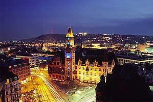
Saarbrücken
Capital of Saarland, Germany
Distance: Approx. 1357 meters
Latitude and longitude: 49.23333333,7
Saarbrücken (German pronunciation: [zaːɐ̯ˈbʁʏkn̩] ; lit. Saar Bridges; Rhenish Franconian: Sabrigge [zaːˈbʁɪɡə]; French: Sarrebruck [saʁbʁyk]; Luxembourgish: Saarbrécken [zaːˈbʀekən] ; Latin: Saravipons) is the capital and largest city of the state of Saarland, Germany. Saarbrücken has 181,959 inhabitants and is Saarland's administrative, commercial and cultural centre.
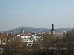
Sankt Johann (Saarbrücken)
Distance: Approx. 1110 meters
Latitude and longitude: 49.232658,6.996285
Sankt Johann is part of the city of Saarbrücken in Saarland, Germany. It lies on the right bank of the Saar, opposite historic Saarbrücken, and is 79 kilometres (49 mi) northeast of Metz, France. Sankt Johann got its name from a chapel erected there.
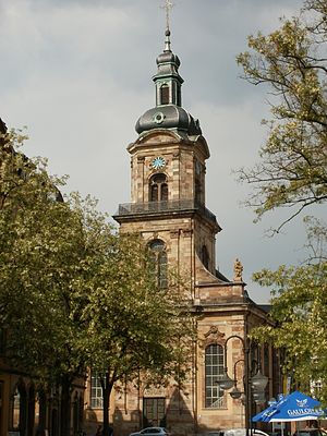
Ludwigskirche
Church in Germany
Distance: Approx. 454 meters
Latitude and longitude: 49.23277778,6.98638889
Ludwigskirche in Old Saarbrücken, Germany, is a Lutheran Baroque-style church. It is the symbol of the city and is considered to be one of the most important Protestant churches in Germany, along with the Dresden Frauenkirche and the St. Michael's Church, Hamburg.

Landtag of Saarland
State diet of the German state of Saarland
Distance: Approx. 1149 meters
Latitude and longitude: 49.229,6.994
The Landtag of the Saarland is the state diet of the German federal state of Saarland. It convenes in Saarbrücken and currently consists of 51 members of five parties. The Social Democratic Party of Germany (SPD) is the largest party in the Landtag with 29 seats, an absolute majority that allows the party to govern without a coalition.

Saarbrücken Hauptbahnhof
Distance: Approx. 932 meters
Latitude and longitude: 49.24138889,6.99055556
Saarbrücken Hauptbahnhof or Saarbrücken Central Station also called Eurobahnhof Saarbrucken, is the principal railway station in the German city of Saarbrücken and the largest station in the Saarland, a German state on the border with France. Around 10 million passengers use the station annually. The station is operated by DB Station&Service as a category 2 station, served by regional and long-distance trains.

Saarbrücken Castle
Distance: Approx. 982 meters
Latitude and longitude: 49.2301,6.9924
Saarbrücken Castle (German: Schloss Saarbrücken) is a Baroque château in Saarbrücken, the capital of Saarland. It is located in the district of Alt-Saarbrücken on the left bank of the Saar. Earlier, a medieval castle and a Renaissance castle stood on the same site.

Kongreßhalle (Saarbrücken)
Distance: Approx. 504 meters
Latitude and longitude: 49.23777778,6.9875
The Kongreßhalle is a concert hall located in Saarbrücken, Germany, which was designed by German architect Dieter Oesterlen. The main hall can seat 1,300 and can hold 1,800 for standing events. The Kongreßhalle opened in 1967 and was expanded and moved to new premises in 1995.

Platz des Unsichtbaren Mahnmals
Distance: Approx. 909 meters
Latitude and longitude: 49.2305,6.9916
The Platz des Unsichtbaren Mahnmals – or in English, the Place of the Invisible Memorial – is a memorial to Jewish cemeteries. It is located in Saarbrücken, capital of the German state of the Saarland. To the visitor, the memorial is completely invisible – it only appears as a sign at the place, reading "Platz des Unsichtbaren Mahnmals".
Hochschule für Musik Saar
Distance: Approx. 1307 meters
Latitude and longitude: 49.2303,6.9978
The Hochschule für Musik Saar is a conservatory of music in Saarbrücken, Germany and dates back to 1947. From 1994 until 2002, it was named Hochschule des Saarlandes für Musik und Theater (University of Music and Drama Saarbrücken). Since 2012, the rector is Prof.
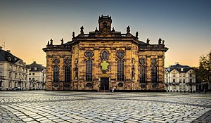
Basilica of St. John the Baptist, Saarbrücken
Church in Saarbrücken, Germany
Distance: Approx. 1250 meters
Latitude and longitude: 49.233,6.9984
The Basilica of St. John the Baptist (German: Basilika St. Johannes der Täufer ) also called Saarbrücken Basilica Is a catholic basilica located in the market of St.

Landesbank Saar
Distance: Approx. 970 meters
Latitude and longitude: 49.239461,6.993411
Landesbank Saar (short SaarLB) is a public-law corporation established in Saarbrücken and the largest credit and mortgage bond institute in Saarland. In 2017, the balance sheet total was around €14 billion. Core markets are Saarland and France, especially the northeast of the country.

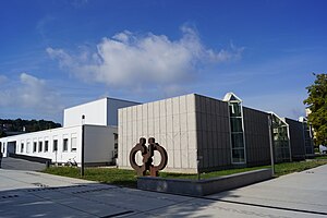
Hochschule der Bildenden Künste Saar
University in Saarland, Germany
Distance: Approx. 407 meters
Latitude and longitude: 49.2325,6.985
The Hochschule der Bildenden Künste Saar or HBKsaar, (English: Saar College of Fine Arts) is an art and design university in the German State of Saarland. The degree course offers a choice of different topics: Fine arts, communication design, media art & design and product design. There are also various master study programmes and teacher training programmes in art education.
Weather in this IP's area
light rain
20 Celsius
21 Celsius
19 Celsius
21 Celsius
1016 hPa
86 %
1016 hPa
993 hPa
10000 meters
3.6 m/s
270 degree
75 %
05:57:43
21:19:12