Country:
 France
Region:
City:
Latitude and Longitude:
Time Zone:
Postal Code:
IP information under different IP Channel
ip-api
Country
Region
City
ASN
Time Zone
ISP
Blacklist
Proxy
Latitude
Longitude
Postal
Route
IPinfo
Country
Region
City
ASN
Time Zone
ISP
Blacklist
Proxy
Latitude
Longitude
Postal
Route
MaxMind
Country
Region
City
ASN
Time Zone
ISP
Blacklist
Proxy
Latitude
Longitude
Postal
Route
Luminati
Country
FRRegion
occ
City
montpellier
ASN
Time Zone
Europe/Paris
ISP
ADISTA SAS
Latitude
Longitude
Postal
db-ip
Country
Region
City
ASN
Time Zone
ISP
Blacklist
Proxy
Latitude
Longitude
Postal
Route
ipdata
Country
Region
City
ASN
Time Zone
ISP
Blacklist
Proxy
Latitude
Longitude
Postal
Route
Popular places and events near this IP address

Angoulême
Prefecture and commune in Nouvelle-Aquitaine, France
Distance: Approx. 3113 meters
Latitude and longitude: 45.65,0.16
Angoulême (French pronunciation: [ɑ̃ɡulɛːm] ; Poitevin-Saintongeais: Engoulaeme; Occitan: Engoleime) is a small city in the southwestern French department of Charente, of which it is the prefecture. Located on a plateau overlooking a meander of the river Charente, the city is nicknamed the "balcony of the southwest". The city proper's population is a little less than 42,000 but it is the centre of an urban area of 110,000 people extending more than fifteen kilometres (9.3 miles) from east to west.

Angoumois
Place in France
Distance: Approx. 2594 meters
Latitude and longitude: 45.65,0.16666667
Angoumois (French pronunciation: [ɑ̃ɡumwa]), historically the County of Angoulême, was a county and province of France, originally inferior to the parent duchy of Aquitaine, similar to the Périgord to its east but lower and generally less forested, equally with occasional vineyards throughout. Its capital was Angoulême with its citadel and castle above the river Charente. It almost corresponds to the Charente Department which also takes in the east of the coastal comté de Saintonge.

Château d'Angoulême
Castle in the town of Angoulême, in the Charente département of France
Distance: Approx. 3420 meters
Latitude and longitude: 45.64833333,0.15611111
The Château d'Angoulême was a castle in the town of Angoulême, in the Charente département of France. The only remaining parts are the keep of Lusignan and the tower of Valois, which are part of the Town Hall of Angoulême, together with a construction of the 19th century.
Soyaux
Commune in Nouvelle-Aquitaine, France
Distance: Approx. 964 meters
Latitude and longitude: 45.6414,0.1986
Soyaux (French pronunciation: [swajo] or [sojo]) is a commune in the Charente department in the Nouvelle-Aquitaine region in southwestern France.

Stade Camille-Lebon
Football stadium in Angoulême, France
Distance: Approx. 2065 meters
Latitude and longitude: 45.64189444,0.17612778
The Stade Camille-Lebon is a stadium in Angoulême, France. It is used mostly for football matches and is the home ground of Angoulême Charente FC. The stadium is able to hold 6,500 people.

Circuit des Remparts
Race circuit in Angoulême, France
Distance: Approx. 3351 meters
Latitude and longitude: 45.64944444,0.15694444
Circuit des Remparts is a historic race circuit in Angoulême, France, using the town's ancient road layout.

L'Isle-d'Espagnac
Commune in Nouvelle-Aquitaine, France
Distance: Approx. 1359 meters
Latitude and longitude: 45.6622,0.2006
L'Isle-d'Espagnac (French pronunciation: [lil depaɲak]) is a commune in the Charente department in southwestern France.

1st Marine Infantry Regiment
Military unit
Distance: Approx. 2031 meters
Latitude and longitude: 45.64416667,0.17527778
The 1st Marine Infantry Regiment (French: 1er régiment d'infanterie de marine, 1er RIMa) is a French regiment heir of the colonial infantry. The regiment is one of the quatre vieux regiments of the Troupes de Marine, with the 2nd Marine Infantry Regiment 2e RIMa, the 3rd Marine Infantry Regiment 3e RIMa, as well the 4th Marine Infantry Regiment 4e RIMa (dissolved in 1998). Along with the 1st Marine Artillery Regiment 1er RAMa and the 2nd Marine Artillery Regiment 2e RAMa, the 1st Marine formed the Blue Division.
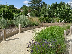
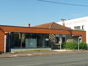
Sentier botanique de Soyaux
Distance: Approx. 965 meters
Latitude and longitude: 45.64138889,0.19861111
The Sentier botanique de Soyaux (200 metres long) is an arboretum and botanical path located on the Chemin de la Mothe, rue du Bourg, Soyaux, Charente, Nouvelle-Aquitaine, France. It was created in 2000 along the remains of a rural road, and planted with 42 species of regional trees and shrubs (32 deciduous, 10 evergreen). The path is open daily without charge.

Angoulême station
Distance: Approx. 2741 meters
Latitude and longitude: 45.65416667,0.16527778
Angoulême is a railway station located in Angoulême, Charente, south-western France. The station was opened in 1852 and is located on the Paris–Bordeaux railway, Saintes-Angoulême railway and Limoges-Angoulême railway. The train services are operated by SNCF. The station building is part of the former Collège Royal de la Marine, as testified by an enamel plaque in the booking hall.
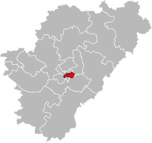
Canton of Angoulême-3
Canton in Nouvelle-Aquitaine, France
Distance: Approx. 2587 meters
Latitude and longitude: 45.64,0.17
The canton of Angoulême-3 is an administrative division of the Charente department, southwestern France. It was created at the French canton reorganisation which came into effect in March 2015. Its seat is in Angoulême.
Grand Angoulême
Communauté d'agglomération in Nouvelle-Aquitaine, France
Distance: Approx. 3189 meters
Latitude and longitude: 45.66666667,0.16666667
Grand Angoulême is the communauté d'agglomération, an intercommunal structure, centred on the city of Angoulême. It is located in the Charente department, in the Nouvelle-Aquitaine region, southwestern France. It was created in January 2017.
Weather in this IP's area
clear sky
27 Celsius
28 Celsius
26 Celsius
27 Celsius
1020 hPa
56 %
1020 hPa
1005 hPa
10000 meters
3.6 m/s
30 degree
06:38:16
21:32:53