Country:
 France
Region:
City:
Latitude and Longitude:
Time Zone:
Postal Code:
IP information under different IP Channel
ip-api
Country
Region
City
ASN
Time Zone
ISP
Blacklist
Proxy
Latitude
Longitude
Postal
Route
IPinfo
Country
Region
City
ASN
Time Zone
ISP
Blacklist
Proxy
Latitude
Longitude
Postal
Route
MaxMind
Country
Region
City
ASN
Time Zone
ISP
Blacklist
Proxy
Latitude
Longitude
Postal
Route
Luminati
Country
FRRegion
occ
City
montpellier
ASN
Time Zone
Europe/Paris
ISP
ADISTA SAS
Latitude
Longitude
Postal
db-ip
Country
Region
City
ASN
Time Zone
ISP
Blacklist
Proxy
Latitude
Longitude
Postal
Route
ipdata
Country
Region
City
ASN
Time Zone
ISP
Blacklist
Proxy
Latitude
Longitude
Postal
Route
Popular places and events near this IP address

Angoulême
Prefecture and commune in Nouvelle-Aquitaine, France
Distance: Approx. 3743 meters
Latitude and longitude: 45.65,0.16
Angoulême (French pronunciation: [ɑ̃ɡulɛːm] ; Poitevin-Saintongeais: Engoulaeme; Occitan: Engoleime) is a small city in the southwestern French department of Charente, of which it is the prefecture. Located on a plateau overlooking a meander of the river Charente, the city is nicknamed the "balcony of the southwest". The city proper's population is a little less than 42,000 but it is the centre of an urban area of 110,000 people extending more than fifteen kilometres (9.3 miles) from east to west.

Angoumois
Place in France
Distance: Approx. 3707 meters
Latitude and longitude: 45.65,0.16666667
Angoumois (French pronunciation: [ɑ̃ɡumwa]), historically the County of Angoulême, was a county and province of France, originally inferior to the parent duchy of Aquitaine, similar to the Périgord to its east but lower and generally less forested, equally with occasional vineyards throughout. Its capital was Angoulême with its citadel and castle above the river Charente. It almost corresponds to the Charente Department which also takes in the east of the coastal comté de Saintonge.

Circuit des Remparts
Race circuit in Angoulême, France
Distance: Approx. 3844 meters
Latitude and longitude: 45.64944444,0.15694444
Circuit des Remparts is a historic race circuit in Angoulême, France, using the town's ancient road layout.
Balzac, Charente
Commune in Nouvelle-Aquitaine, France
Distance: Approx. 3807 meters
Latitude and longitude: 45.7106,0.1372
Balzac (French pronunciation: [balzak]) is a commune in the Charente department in the Nouvelle-Aquitaine region of south-western France.

Gond-Pontouvre
Commune in Nouvelle-Aquitaine, France
Distance: Approx. 1582 meters
Latitude and longitude: 45.6692,0.1642
Gond-Pontouvre (French pronunciation: [ɡɔ̃ pɔ̃tuvʁ]) is a commune in the Charente department in southwestern France. It is about 3 km north of the centre of Angoulême.

L'Isle-d'Espagnac
Commune in Nouvelle-Aquitaine, France
Distance: Approx. 3531 meters
Latitude and longitude: 45.6622,0.2006
L'Isle-d'Espagnac (French pronunciation: [lil depaɲak]) is a commune in the Charente department in southwestern France.

Saint-Yrieix-sur-Charente
Commune in Nouvelle-Aquitaine, France
Distance: Approx. 3116 meters
Latitude and longitude: 45.6758,0.1281
Saint-Yrieix-sur-Charente (French pronunciation: [sɛ̃tiʁje syʁ ʃaʁɑ̃t]; Occitan: Sent Iriès de Charanta) is a commune in the Charente department, southwestern France.

Angoulême station
Distance: Approx. 3245 meters
Latitude and longitude: 45.65416667,0.16527778
Angoulême is a railway station located in Angoulême, Charente, south-western France. The station was opened in 1852 and is located on the Paris–Bordeaux railway, Saintes-Angoulême railway and Limoges-Angoulême railway. The train services are operated by SNCF. The station building is part of the former Collège Royal de la Marine, as testified by an enamel plaque in the booking hall.

Abbey of Saint-Cybard
Distance: Approx. 3615 meters
Latitude and longitude: 45.653,0.15
The Abbey of Saint-Cybard was a Benedictine monastery located just outside the northern city walls of Angoulême. According to Gregory of Tours in the Historia Francorum (VI, 8), the monastery was founded by Saint Eparchius in the sixth century. Little is known about the institution after its founding until 852, when King Charles the Bald confirmed a series of gifts to the abbey made by Abbot Launus, who was also the bishop of Angoulême.

Canton of Angoulême-2
Canton in Nouvelle-Aquitaine, France
Distance: Approx. 2901 meters
Latitude and longitude: 45.66,0.15
The canton of Angoulême-2 is an administrative division of the Charente department, southwestern France. It was created at the French canton reorganisation which came into effect in March 2015. Its seat is in Angoulême.
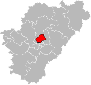
Canton of Gond-Pontouvre
Canton in Nouvelle-Aquitaine, France
Distance: Approx. 638 meters
Latitude and longitude: 45.68,0.16
The canton of Gond-Pontouvre is an administrative division of the Charente department, southwestern France. Its borders were not modified at the French canton reorganisation which came into effect in March 2015. Its seat is in Gond-Pontouvre.
Grand Angoulême
Communauté d'agglomération in Nouvelle-Aquitaine, France
Distance: Approx. 1852 meters
Latitude and longitude: 45.66666667,0.16666667
Grand Angoulême is the communauté d'agglomération, an intercommunal structure, centred on the city of Angoulême. It is located in the Charente department, in the Nouvelle-Aquitaine region, southwestern France. It was created in January 2017.
Weather in this IP's area
clear sky
25 Celsius
25 Celsius
23 Celsius
25 Celsius
1020 hPa
62 %
1020 hPa
1012 hPa
10000 meters
4.63 m/s
50 degree
06:38:18
21:33:07