Country:
 France
Region:
City:
Latitude and Longitude:
Time Zone:
Postal Code:
IP information under different IP Channel
ip-api
Country
Region
City
ASN
Time Zone
ISP
Blacklist
Proxy
Latitude
Longitude
Postal
Route
IPinfo
Country
Region
City
ASN
Time Zone
ISP
Blacklist
Proxy
Latitude
Longitude
Postal
Route
MaxMind
Country
Region
City
ASN
Time Zone
ISP
Blacklist
Proxy
Latitude
Longitude
Postal
Route
Luminati
Country
FRRegion
idf
City
draveil
ASN
Time Zone
Europe/Paris
ISP
ADISTA SAS
Latitude
Longitude
Postal
db-ip
Country
Region
City
ASN
Time Zone
ISP
Blacklist
Proxy
Latitude
Longitude
Postal
Route
ipdata
Country
Region
City
ASN
Time Zone
ISP
Blacklist
Proxy
Latitude
Longitude
Postal
Route
Popular places and events near this IP address
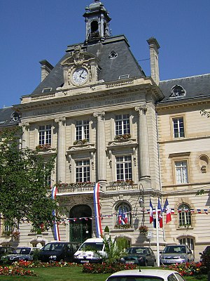
Meaux
Subprefecture and commune in Île-de-France, France
Distance: Approx. 1956 meters
Latitude and longitude: 48.9603,2.8883
Meaux (French pronunciation: [mo] ) is a commune on the river Marne in the Seine-et-Marne department in the Île-de-France region in the metropolitan area of Paris, France. It is 41.1 km (25.5 mi) east-northeast of the centre of Paris. Meaux is, with Provins, Torcy and Fontainebleau, one of the four subprefectures (sous-préfectures) of the department of Seine-et-Marne, Melun being the prefecture.

Arrondissement of Meaux
Arrondissement in Île-de-France, France
Distance: Approx. 1635 meters
Latitude and longitude: 48.95777778,2.88555556
The arrondissement of Meaux is an arrondissement of France in the Seine-et-Marne department in the Île-de-France region. It has 142 communes. Its population is 337,296 (2019), and its area is 1,343.3 km2 (518.7 sq mi).

Siege of Meaux
1421–1422 siege in the Hundred Years' War
Distance: Approx. 1956 meters
Latitude and longitude: 48.9603,2.8883
The siege of Meaux was fought from October 1421 to May 1422 between the English and the French during the Hundred Years' War. The English were led by King Henry V. Henry became ill while pressing this long siege, which took place during the winter months, and died on 31 August as a result.
Roman Catholic Diocese of Meaux
Catholic diocese in France
Distance: Approx. 1480 meters
Latitude and longitude: 48.9602,2.87975
The Diocese of Meaux (Latin: Dioecesis Meldensis; French: Diocèse de Meaux) is a Latin diocese of the Catholic Church in France. The diocese comprises the entire department of Seine-et-Marne. It was suffragan of the Archdiocese of Sens until 1622, and subsequently of Archdiocese of Paris.

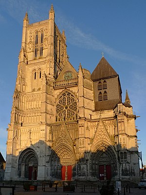
Meaux Cathedral
Roman Catholic cathedral in Meaux, France
Distance: Approx. 1423 meters
Latitude and longitude: 48.96,2.87888889
Meaux Cathedral (French: Cathédrale Saint-Étienne de Meaux, lit. 'Meaux St. Stephen Cathedral') is a Roman Catholic church in the town of Meaux, Seine-et-Marne, France, and a cathedral as the seat of the Bishop of Meaux. It is a historical monument of France.
Canton of Meaux-Sud
Former canton in Île-de-France, France
Distance: Approx. 1766 meters
Latitude and longitude: 48.93805556,2.88194444
The canton of Meaux-Sud is a French former administrative division, located in the arrondissement of Meaux, in the Seine-et-Marne département (Île-de-France région). It was disbanded following the French canton reorganisation which came into effect in March 2015.

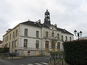
Mareuil-lès-Meaux
Commune in Île-de-France, France
Distance: Approx. 2687 meters
Latitude and longitude: 48.9266,2.8587
Mareuil-lès-Meaux (French pronunciation: [maʁœj lɛ mo] , literally Mareuil near Meaux) is a commune in the Seine-et-Marne department in the Île-de-France region in north-central France.
Nanteuil-lès-Meaux
Commune in Île-de-France, France
Distance: Approx. 3176 meters
Latitude and longitude: 48.9297,2.8966
Nanteuil-lès-Meaux (French pronunciation: [nɑ̃tœj lɛ mo] , literally Nanteuil near Meaux) is a commune in the Seine-et-Marne department in the Île-de-France region in north-central France.

Villenoy
Commune in Île-de-France, France
Distance: Approx. 795 meters
Latitude and longitude: 48.9433,2.8636
Villenoy (French: [vilnwa] ) is a commune in the Seine-et-Marne department in the Île-de-France region in north-central France.
Communauté d'agglomération du Pays de Meaux
Communauté d'agglomération in Île-de-France, France
Distance: Approx. 1476 meters
Latitude and longitude: 48.96,2.88
The Communauté d'agglomération du Pays de Meaux (CAPM) is a communauté d'agglomération in the Seine-et-Marne département and in the Île-de-France région of France. The 4 communes of the former Communauté de communes des Monts de la Goële were merged into it on 1 January 2017. On 31 December 2019 it was expanded with 4 communes from the former communauté de communes du Pays Créçois.

Meaux station
Distance: Approx. 1021 meters
Latitude and longitude: 48.95805556,2.87361111
Meaux station (French: Gare de Meaux) is a railway station serving Meaux, Seine-et-Marne department, northern France. It is on the Paris–Strasbourg railway, and offers connections to Paris-Est, Château-Thierry and La Ferté-Milon. The rail line connecting Paris to Meaux was established in 1849.
Canton of Meaux
Canton in Île-de-France, France
Distance: Approx. 1476 meters
Latitude and longitude: 48.96,2.88
The canton of Meaux is an administrative division of the Seine-et-Marne department, in northern France. It was created at the French canton reorganisation which came into effect in March 2015. Its seat is in Meaux.
Weather in this IP's area
overcast clouds
17 Celsius
17 Celsius
16 Celsius
18 Celsius
1025 hPa
89 %
1025 hPa
1018 hPa
10000 meters
2.23 m/s
3.14 m/s
67 degree
99 %
06:16:33
21:33:16