Country:
 France
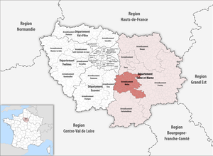
Region:
City:
Latitude and Longitude:
Time Zone:
Postal Code:
IP information under different IP Channel
ip-api
Country
Region
City
ASN
Time Zone
ISP
Blacklist
Proxy
Latitude
Longitude
Postal
Route
IPinfo
Country
Region
City
ASN
Time Zone
ISP
Blacklist
Proxy
Latitude
Longitude
Postal
Route
MaxMind
Country
Region
City
ASN
Time Zone
ISP
Blacklist
Proxy
Latitude
Longitude
Postal
Route
Luminati
Country
FRRegion
idf
City
draveil
ASN
Time Zone
Europe/Paris
ISP
ADISTA SAS
Latitude
Longitude
Postal
db-ip
Country
Region
City
ASN
Time Zone
ISP
Blacklist
Proxy
Latitude
Longitude
Postal
Route
ipdata
Country
Region
City
ASN
Time Zone
ISP
Blacklist
Proxy
Latitude
Longitude
Postal
Route
Popular places and events near this IP address

Melun
Prefecture and commune in Île-de-France, France
Distance: Approx. 951 meters
Latitude and longitude: 48.5406,2.66
Melun (French pronunciation: [məlœ̃] ) is a commune in the Seine-et-Marne department in the Île-de-France region, north-central France. It is located on the southeastern outskirts of Paris, about 41 kilometres (25+1⁄2 miles) from the centre of the capital. Melun is the prefecture of Seine-et-Marne, and the seat of one of its arrondissements.
Arrondissement of Melun
Arrondissement in Île-de-France, France
Distance: Approx. 969 meters
Latitude and longitude: 48.54055556,2.65944444
The arrondissement of Melun is an arrondissement of France in the Seine-et-Marne department in the Île-de-France region. It has 59 communes. Its population is 283,360 (2019), and its area is 617.1 km2 (238.3 sq mi).

Dammarie-lès-Lys
Commune in Île-de-France, France
Distance: Approx. 2614 meters
Latitude and longitude: 48.5177,2.6402
Dammarie-lès-Lys (French pronunciation: [damaʁi le lis] ; officially Dammarie-les-Lys) is a commune in the south-eastern suburbs of Paris, France. It is located in the Seine-et-Marne department in the Île-de-France region 43.3 km (26.9 mi) from the center of Paris.
Canton of Melun-Sud
Former canton in Île-de-France, France
Distance: Approx. 1461 meters
Latitude and longitude: 48.52027778,2.66916667
The canton of Melun-Sud is a French former administrative division, located in the arrondissement of Melun, in the Seine-et-Marne département (Île-de-France région). It was disbanded following the French canton reorganisation which came into effect in March 2015. It consisted of 3 communes, which joined the canton of Melun in 2015.
Vaux-le-Pénil
Commune in Île-de-France, France
Distance: Approx. 1434 meters
Latitude and longitude: 48.5257,2.6824
Vaux-le-Pénil (French pronunciation: [vo lə penil] ) is a commune in the Seine-et-Marne department in the Île-de-France region in north-central France.
Communauté d'agglomération Melun Val de Seine
Communauté d'agglomération in Île-de-France, France
Distance: Approx. 895 meters
Latitude and longitude: 48.54,2.66
The Communauté d'agglomération Melun Val de Seine is a communauté d'agglomération in the Seine-et-Marne département and in the Île-de-France région of France, centred on the city of Melun. Its area is 153.2 km2. Its population was 131,924 in 2018, of which 39,947 in Melun proper.

Melun station
Distance: Approx. 1112 meters
Latitude and longitude: 48.52722222,2.65472222
Melun station (French: Gare de Melun) is a railway station in Melun, Seine-et-Marne, Paris, France. The station was opened on 3 January 1849 and is on the Paris–Marseille railway.

Almont (river)
River in France
Distance: Approx. 420 meters
Latitude and longitude: 48.5357,2.6623
The Almont is a river in the Ile-de-France region of northern France. It traverses the department of Seine-et-Marne for a total length of 42 kilometres (26 mi), and empties into the Seine in Melun. Its source is located between the towns of Nangis and Rampillon.
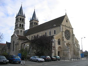
Collegiate Church of Notre-Dame, Melun
Church in Seine-et-Marne, France
Distance: Approx. 536 meters
Latitude and longitude: 48.53555556,2.66027778
The Collegiate Church of Notre-Dame (Collégiale Notre-Dame de Melun) was a collegiate church, now a parish church in the French town of Melun, on rue de la Courtille on the île Saint-Etienne.
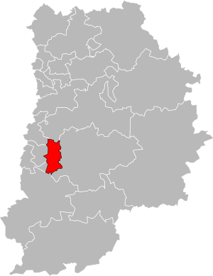
Canton of Melun
Canton in Île-de-France, France
Distance: Approx. 0 meters
Latitude and longitude: 48.5333,2.6667
The canton of Melun is a French administrative division, located in the arrondissement of Melun, in the Seine-et-Marne département (Île-de-France région).

National Gendarmerie Museum
Distance: Approx. 1693 meters
Latitude and longitude: 48.54549,2.65296
The National Gendarmerie Museum (French - Musée de la Gendarmerie nationale) is a museum on the history of France's National Gendarmerie. It is sited at 1-3 Rue Émile-Leclerc in the town of Melun. It first opened in 1946 but has since been repeatedly extended.

Stade Municipal de Melun
Stadium in Melun, France
Distance: Approx. 311 meters
Latitude and longitude: 48.531,2.66430556
The Stade Municipal de Melun is a multi-purpose stadium located in Melun, France. It is used for football matches, rugby union matches, and athletic competitions. The stadium is the home ground of Régional 2 club FC Melun, and is used by several sections of Union Sportive Melunaise, a multi-sport club.
Weather in this IP's area
clear sky
17 Celsius
16 Celsius
15 Celsius
18 Celsius
1025 hPa
77 %
1025 hPa
1018 hPa
10000 meters
1.03 m/s
06:18:50
21:32:35