Country:
 France
Region:
City:
Latitude and Longitude:
Time Zone:
Postal Code:
IP information under different IP Channel
ip-api
Country
Region
City
ASN
Time Zone
ISP
Blacklist
Proxy
Latitude
Longitude
Postal
Route
IPinfo
Country
Region
City
ASN
Time Zone
ISP
Blacklist
Proxy
Latitude
Longitude
Postal
Route
MaxMind
Country
Region
City
ASN
Time Zone
ISP
Blacklist
Proxy
Latitude
Longitude
Postal
Route
Luminati
Country
FRRegion
idf
City
draveil
ASN
Time Zone
Europe/Paris
ISP
ADISTA SAS
Latitude
Longitude
Postal
db-ip
Country
Region
City
ASN
Time Zone
ISP
Blacklist
Proxy
Latitude
Longitude
Postal
Route
ipdata
Country
Region
City
ASN
Time Zone
ISP
Blacklist
Proxy
Latitude
Longitude
Postal
Route
Popular places and events near this IP address

Lille
Prefecture and commune in Hauts-de-France, France
Distance: Approx. 558 meters
Latitude and longitude: 50.6278,3.0583
Lille ( LEEL, French: [lil] ; Dutch: Rijsel [ˈrɛisəl]; Picard: Lile; West Flemish: Rysel) is a city in the northern part of France, within French Flanders. Positioned along the Deûle river, near France's border with Belgium, it is the capital of the Hauts-de-France region, the prefecture of the Nord department, and the main city of the European Metropolis of Lille. The city of Lille proper had a population of 236,234 in 2020 within its small municipal territory of 35 km2 (14 sq mi), but together with its French suburbs and exurbs the Lille metropolitan area (French part only), which extends over 1,666 km2 (643 sq mi), had a population of 1,515,061 that same year (Jan.

Métropole Européenne de Lille
Métropole in Hauts-de-France, France
Distance: Approx. 577 meters
Latitude and longitude: 50.63722222,3.06305556
The Métropole Européenne de Lille (MEL; English: "European Metropolis of Lille") is the métropole, an intercommunal structure, composed by a network of big cities (Lille, Roubaix, Tourcoing, Villeneuve d'Ascq, Armentières etc.) whose major city is the city of Lille. It is located in the Nord department, in the Hauts-de-France region, northern France – bordering both the Flemish and Walloon regions of Belgium. It was created in January 2015, replacing the previous Communauté urbaine de Lille, and covers that part of the Lille metropolitan area that lies in France.

Column of the Goddess
1792 siege during the War of the First Coalition
Distance: Approx. 562 meters
Latitude and longitude: 50.63694444,3.06333333
The Column of the Goddess is the popular name given by the citizens of Lille (France) to the Memorial of the Siege of 1792. The memorial is still in the center of the Grand′ Place (central square) of Lille, and has been surrounded by a fountain since around 1990.

Siege of Lille (1667)
Episode of the war of Devolution
Distance: Approx. 410 meters
Latitude and longitude: 50.62925,3.05725556
The siege of Lille took place during the War of Devolution. Louis XIV's forces besieged Lille from 10 August to 28 August 1667. It was the only major engagement of the war.

Siege of Lille (1708)
Distance: Approx. 584 meters
Latitude and longitude: 50.6372,3.0633
The siege of Lille (12 August – 10 December 1708) was the salient operation of the 1708 campaign season during the War of the Spanish Succession. After an obstinate defence of 120 days, the French garrison surrendered the city and citadel of Lille, commanded by Marshal Boufflers, to the forces of the Duke of Marlborough and Prince Eugene. The siege was famous among contemporaries for l'affaire des poudres ("the gunpowder incident"), where the Chevalier de Luxembourg with 2,000 horsemen passed through the Allied lines and succeeded in delivering 40,000 pounds of desperately needed gunpowder to the defenders.

Palais des Beaux-Arts de Lille
Art gallery in Lille, France
Distance: Approx. 398 meters
Latitude and longitude: 50.630353,3.062906
The Palais des Beaux-Arts de Lille (Lille Palace of Fine Arts) is a municipal museum dedicated to fine arts, modern art, and antiquities located in Lille. It is one of the largest art museums in France. It was one of the first museums built in France, established under the instructions of Napoleon I at the beginning of the 19th century as part of the popularisation of art.

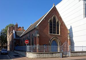
Church of Saint-Étienne, Lille
Church in Lille, France
Distance: Approx. 272 meters
Latitude and longitude: 50.63515833,3.05978611
The Church of Saint-Étienne, Lille (French: Église Saint-Étienne de Lille) is a Roman Catholic church located on the rue de l'Hôpital Militaire in Lille, France. It has been classed as a monument historique since 1987 and is dedicated to Saint Stephen. It is one of the largest Jesuit churches in France.
Siege of Lille (1792)
Battle
Distance: Approx. 560 meters
Latitude and longitude: 50.62777778,3.05833333
The siege of Lille (25 September – 8 October 1792) saw a Republican French garrison under Jean-Baptiste André Ruault de La Bonnerie hold Lille against an assault by a Habsburg army commanded by Duke Albert of Saxe-Teschen. Though the city was fiercely bombarded, the French successfully withstood the Austrian attack in the action. Because the Austrians were unable to completely encircle the city, the French were able to continuously send in reinforcements.
Christ Church, Lille
Distance: Approx. 597 meters
Latitude and longitude: 50.6302,3.0662
Christ Church Lille is an English-speaking Anglican Church located in the city of Lille in Nord-Pas-de-Calais, the Flemish area of France. Christ Church Lille is part of the Church of England, Diocese in Europe.

École supérieure de journalisme de Lille
Distance: Approx. 576 meters
Latitude and longitude: 50.62880694,3.06399194
The École supérieure de journalisme (ESJ Lille) (in English: Superior School of Journalism of Lille) is a private non-profit institution of higher education, a French Grande École in Lille dedicated to journalism and related studies. The ESJ is a graduate school of the University of Lille as part of a public-private partnership. It has been elected best French journalism school in 2013 by Le Figaro.
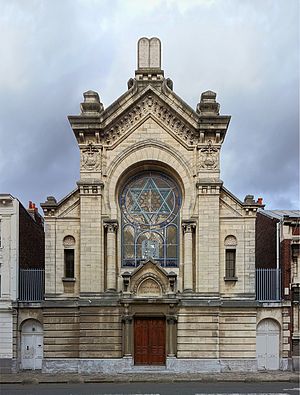
Lille Synagogue
Synagogue located in Nord, in France
Distance: Approx. 676 meters
Latitude and longitude: 50.6284,3.0654
Lille Synagogue (French: Synagogue de Lille) is a Jewish congregation and synagogue, located at 5, rue Auguste Angellie, in Lille, in the Hauts-de-France region of France. The congregation worships in the Ashkenazi rite.

Place du Général-de-Gaulle (Lille)
Plaza in Hauts-de-France, France
Distance: Approx. 562 meters
Latitude and longitude: 50.63694444,3.06333333
Place du Général-de-Gaulle is an urban public space situated in the commune of Lille, Hauts-de-France region. It is the town's historic main square. It has a grand-place style, which is typical of many cities in the former Netherlands.
Weather in this IP's area
few clouds
22 Celsius
22 Celsius
21 Celsius
23 Celsius
1026 hPa
64 %
1026 hPa
1023 hPa
10000 meters
1.54 m/s
20 %
06:09:27
21:38:50