Country:
 France
Region:
City:
Latitude and Longitude:
Time Zone:
Postal Code:
IP information under different IP Channel
ip-api
Country
Region
City
ASN
Time Zone
ISP
Blacklist
Proxy
Latitude
Longitude
Postal
Route
IPinfo
Country
Region
City
ASN
Time Zone
ISP
Blacklist
Proxy
Latitude
Longitude
Postal
Route
MaxMind
Country
Region
City
ASN
Time Zone
ISP
Blacklist
Proxy
Latitude
Longitude
Postal
Route
Luminati
Country
FRRegion
naq
City
bruges
ASN
Time Zone
Europe/Paris
ISP
ADISTA SAS
Latitude
Longitude
Postal
db-ip
Country
Region
City
ASN
Time Zone
ISP
Blacklist
Proxy
Latitude
Longitude
Postal
Route
ipdata
Country
Region
City
ASN
Time Zone
ISP
Blacklist
Proxy
Latitude
Longitude
Postal
Route
Popular places and events near this IP address

Avalon, France
Distance: Approx. 5082 meters
Latitude and longitude: 45.42944444,6.03138889
Avalon is a village outside Pontcharra, Isère département, eastern France. It is part of the commune Saint-Maximin. It is notable for being the birthplace of Saint Hugh of Lincoln (1130s), and for the Tour d'Avalon, a tower in the village.
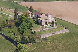
Château Bayard
Distance: Approx. 5300 meters
Latitude and longitude: 45.42361111,6.01888889
The Château Bayard is a castle in the commune of Pontcharra in the département of Isère (Rhône-Alpes, France), and dominates the valley of Grésivaudan in the Dauphiné Alps. Château Bayard has been listed as a monument historique by the French Ministry of Culture since 1915. The castle has housed the Bayard museum since 1975; it presents the life and the myth of Pierre Terrail, seigneur de Bayard, the famous "knight without fear and without reproach" (French: le chevalier sans peur et sans reproche).

Pontcharra
Commune in Auvergne-Rhône-Alpes, France
Distance: Approx. 5929 meters
Latitude and longitude: 45.4327,6.0201
Pontcharra (French pronunciation: [pɔ̃ʃaʁa]; Arpitan: Pont-Charrâ) is a commune in the Isère department in southeastern France.

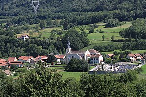
Allevard
Commune in Auvergne-Rhône-Alpes, France
Distance: Approx. 288 meters
Latitude and longitude: 45.3944,6.0747
Allevard (French pronunciation: [alvaʁ]; also known as Allevard-les-Bains) is a commune in the Isère department in the Auvergne-Rhône-Alpes region of southeastern France. The commune has been awarded two flowers by the National Council of Towns and Villages in Bloom in the Competition of Cities and Villages in Bloom.

La Chapelle-Blanche, Savoie
Commune in Auvergne-Rhône-Alpes, France
Distance: Approx. 6146 meters
Latitude and longitude: 45.4486,6.0731
La Chapelle-Blanche (French pronunciation: [la ʃapɛl blɑ̃ʃ] , literally The White Chapel) is a commune in the Savoie department in the Auvergne-Rhône-Alpes region in south-eastern France. The village is located in the Combe de Savoie, on the southwestern slope of the hill Montraillant.

La Chapelle-du-Bard
Commune in Auvergne-Rhône-Alpes, France
Distance: Approx. 3892 meters
Latitude and longitude: 45.4236,6.0964
La Chapelle-du-Bard (French pronunciation: [la ʃapɛl dy baʁ]) is a commune in the Isère department in southeastern France.

Saint-Pierre-d'Allevard
Part of Crêts-en-Belledonne in Auvergne-Rhône-Alpes, France
Distance: Approx. 2660 meters
Latitude and longitude: 45.3756,6.0486
Saint-Pierre-d'Allevard (French pronunciation: [sɛ̃ pjɛʁ dalvaʁ], literally Saint-Pierre of Allevard) is a former commune in the Isère department in southeastern France. On 1 January 2016, it was merged into the new commune of Crêts-en-Belledonne.

Le Moutaret
Commune in Auvergne-Rhône-Alpes, France
Distance: Approx. 4604 meters
Latitude and longitude: 45.4328,6.0892
Le Moutaret (French pronunciation: [lə mutaʁɛ]) is a commune in the Isère department in southeastern France.

Pinsot
Part of Le Haut-Bréda in Auvergne-Rhône-Alpes, France
Distance: Approx. 4585 meters
Latitude and longitude: 45.3578,6.1008
Pinsot (French pronunciation: [pɛ̃so] ) is a former commune in the Isère department in southeastern France. On 1 January 2019, it was merged into the new commune Le Haut-Bréda.
Saint-Maximin, Isère
Commune in Auvergne-Rhône-Alpes, France
Distance: Approx. 4222 meters
Latitude and longitude: 45.42,6.0328
Saint-Maximin (French pronunciation: [sɛ̃ maksimɛ̃]) is a commune in the Isère department in southeastern France.
Crêts en Belledonne
Commune in Auvergne-Rhône-Alpes, France
Distance: Approx. 2929 meters
Latitude and longitude: 45.374,6.046
Crêts en Belledonne (French pronunciation: [kʁɛ ɑ̃ bɛldɔn], literally Crests in Belledonne) is a commune in the Isère department of southeastern France. The municipality was established on 1 January 2016 and consists of the former communes of Saint-Pierre-d'Allevard and Morêtel-de-Mailles.
Canton of Le Haut-Grésivaudan
Distance: Approx. 5716 meters
Latitude and longitude: 45.43,6.02
The canton of Le Haut-Grésivaudan is an administrative division of the Isère department, eastern France. It was created at the French canton reorganisation which came into effect in March 2015. Its seat is in Pontcharra.
Weather in this IP's area
clear sky
27 Celsius
28 Celsius
25 Celsius
28 Celsius
1021 hPa
54 %
1021 hPa
967 hPa
10000 meters
2.04 m/s
1.58 m/s
331 degree
6 %
06:15:34
21:08:37