Country:
 France
Region:
City:
Latitude and Longitude:
Time Zone:
Postal Code:
IP information under different IP Channel
ip-api
Country
Region
City
ASN
Time Zone
ISP
Blacklist
Proxy
Latitude
Longitude
Postal
Route
IPinfo
Country
Region
City
ASN
Time Zone
ISP
Blacklist
Proxy
Latitude
Longitude
Postal
Route
MaxMind
Country
Region
City
ASN
Time Zone
ISP
Blacklist
Proxy
Latitude
Longitude
Postal
Route
Luminati
Country
FRRegion
naq
City
bruges
ASN
Time Zone
Europe/Paris
ISP
ADISTA SAS
Latitude
Longitude
Postal
db-ip
Country
Region
City
ASN
Time Zone
ISP
Blacklist
Proxy
Latitude
Longitude
Postal
Route
ipdata
Country
Region
City
ASN
Time Zone
ISP
Blacklist
Proxy
Latitude
Longitude
Postal
Route
Popular places and events near this IP address

Amiens
Capital of the French department of Somme
Distance: Approx. 895 meters
Latitude and longitude: 49.892,2.299
Amiens (English: or AM-ee-ənz; French: [amjɛ̃] ; Picard: Anmien, Anmiens or Anmyin) is a city and commune in northern France, located 120 km (75 mi) north of Paris and 100 km (62 mi) south-west of Lille. It is the capital of the Somme department in the region of Hauts-de-France and had a population of 135,429, as of 2021. A central landmark of the city is Amiens Cathedral, the largest Gothic cathedral in France.

Battle of Amiens (1918)
First World War allied offensive operation
Distance: Approx. 810 meters
Latitude and longitude: 49.89388889,2.29416667
The Battle of Amiens, also known as the Third Battle of Picardy (French: 3ème Bataille de Picardie), was the opening phase of the Allied offensive which began on 8 August 1918, later known as the Hundred Days Offensive, that ultimately led to the end of the First World War. Allied forces advanced over 11 kilometres (7 mi) on the first day, one of the greatest advances of the war, with Gen Henry Rawlinson's British Fourth Army (with 9 of its 19 divisions supplied by the fast moving Australian Corps of Lt Gen John Monash and Canadian Corps of Lt Gen Arthur Currie) and Gen Marie Eugène Debeney's French First Army playing the decisive role. The battle is also notable for its effects on both sides' morale and the large number of surrendering German forces.

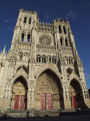
Amiens Cathedral
Church in Amiens, France
Distance: Approx. 573 meters
Latitude and longitude: 49.895,2.30222222
The Cathedral Basilica of Our Lady of Amiens (French: Basilique Cathédrale Notre-Dame d'Amiens), or simply Amiens Cathedral, is a Catholic cathedral. The cathedral is the seat of the Bishop of Amiens. It is situated on a slight ridge overlooking the River Somme in Amiens, the administrative capital of the Picardy region of France, some 120 kilometres (75 miles) north of Paris.
Roman Catholic Diocese of Amiens
Catholic diocese in France
Distance: Approx. 656 meters
Latitude and longitude: 49.8942,2.30189
The Diocese of Amiens (Latin: Dioecesis Ambianensis; French: Diocèse d'Amiens) is a Latin Church diocese of the Catholic Church in France. The diocese comprises the department of Somme, of which the city of Amiens is the capital.

Roman Catholic Diocese of Arras
Catholic diocese in France
Distance: Approx. 592 meters
Latitude and longitude: 49.8947,2.30104
The Diocese of Arras (–Boulogne–Saint-Omer) (Latin: Dioecesis Atrebatensis (–Bononiena–Audomarensis); French: Diocèse d'Arras (–Boulogne–Saint-Omer)) is a Latin Church diocese of the Catholic Church in France. The episcopal see is the Arras Cathedral, in the city of Arras. The diocese encompasses all of the Department of Pas-de-Calais, in the Region of Hauts-de-France.
Canton of Amiens-1
Canton in Hauts-de-France, France
Distance: Approx. 739 meters
Latitude and longitude: 49.9,2.29
The Canton of Amiens-1 is a canton situated in the department of the Somme and in the Hauts-de-France region of northern France.
Canton of Amiens-3
Canton in Hauts-de-France, France
Distance: Approx. 22 meters
Latitude and longitude: 49.9,2.3
The Canton of Amiens-3 is a canton situated in the department of the Somme and in the Hauts-de-France region of northern France.
Amiens 8th (Nord) Canton
Former canton in Hauts-de-France, France
Distance: Approx. 874 meters
Latitude and longitude: 49.89222222,2.29861111
The Amiens 8th (Nord) Canton is a former canton situated in the department of the Somme and in the Picardy region of northern France. It was disbanded following the French canton reorganisation which came into effect in March 2015. It had 16,103 inhabitants (2012).
County of Amiens
Medieval feudal state centred on Amiens, France
Distance: Approx. 22 meters
Latitude and longitude: 49.9,2.3
The County of Amiens (also: Amiénois) was a feudal state centred on the city of Amiens, northern France, that existed from the 9th century until 1077 when the last count became a monk and the county reverted to the French crown. In 1185 the county was united with the French crown under King Philip II of France.

Siege of Amiens (1597)
16th century battle in France
Distance: Approx. 895 meters
Latitude and longitude: 49.892,2.299
The siege of Amiens (French: Siège d'Amiens) was a siege and battle fought during the Franco-Spanish War (1595–1598), as part of both the French Wars of Religion and the Anglo-Spanish War (1585–1604), between 13 May and 25 September 1597. The Spanish, who had sent a large army in March, had captured the city of Amiens easily in a ruse. Henry IV of France, after the surprise of the capture, immediately and quickly built up an army which included a large English force and besieged Amiens on 13 May.
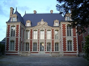
Hotel de Berny Museum
History museum in Amiens, France
Distance: Approx. 831 meters
Latitude and longitude: 49.89273,2.30296
The Hotel de Berny Museum (French: Musée d'art local et d'histoire régionale or Musée de l'Hôtel de Berny) is a local history museum for the region of Picardy. It is located in Amiens. It is currently closed for building works.

Amiens Synagogue
Orthodox synagogue located in Somme, France
Distance: Approx. 801 meters
Latitude and longitude: 49.89485,2.30811
The Amiens Synagogue (French: Synagogue d'Amiens) is an Orthodox Jewish congregation and synagogue, located in the city of Amiens in the Department of Somme, France. The synagogue, rededicated in 2017, replaced two previous buildings.
Weather in this IP's area
broken clouds
24 Celsius
24 Celsius
22 Celsius
24 Celsius
1026 hPa
57 %
1026 hPa
1023 hPa
10000 meters
2.3 m/s
2.52 m/s
94 degree
79 %
06:15:19
21:39:02