Country:
 France
Region:
City:
Latitude and Longitude:
Time Zone:
Postal Code:
IP information under different IP Channel
ip-api
Country
Region
City
ASN
Time Zone
ISP
Blacklist
Proxy
Latitude
Longitude
Postal
Route
IPinfo
Country
Region
City
ASN
Time Zone
ISP
Blacklist
Proxy
Latitude
Longitude
Postal
Route
MaxMind
Country
Region
City
ASN
Time Zone
ISP
Blacklist
Proxy
Latitude
Longitude
Postal
Route
Luminati
Country
FRRegion
naq
City
bruges
ASN
Time Zone
Europe/Paris
ISP
ADISTA SAS
Latitude
Longitude
Postal
db-ip
Country
Region
City
ASN
Time Zone
ISP
Blacklist
Proxy
Latitude
Longitude
Postal
Route
ipdata
Country
Region
City
ASN
Time Zone
ISP
Blacklist
Proxy
Latitude
Longitude
Postal
Route
Popular places and events near this IP address

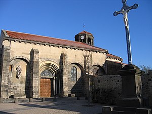
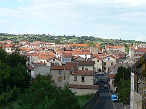
Riom
Subprefecture and commune in Auvergne-Rhône-Alpes, France
Distance: Approx. 677 meters
Latitude and longitude: 45.8944,3.1133
Riom (French pronunciation: [ʁjɔ̃] ; Auvergnat Riam) is a commune in the Puy-de-Dôme department in Auvergne in central France. It is a sub-prefecture of the department.

Arrondissement of Riom
Arrondissement in Auvergne-Rhône-Alpes, France
Distance: Approx. 968 meters
Latitude and longitude: 45.89222222,3.11111111
The arrondissement of Riom is an arrondissement of France in the Puy-de-Dôme department in the Auvergne-Rhône-Alpes region. It has 155 communes. Its population is 135,164 (2016), and its area is 2,705.3 km2 (1,044.5 sq mi).

Abbey of Saint-Pierre Mozac
Distance: Approx. 2042 meters
Latitude and longitude: 45.89044167,3.09419722
Mozac Abbey is a former Cluniac monastery in the commune of Mozac near Riom in Auvergne, France.
Marsat
Commune in Auvergne-Rhône-Alpes, France
Distance: Approx. 3669 meters
Latitude and longitude: 45.8772,3.0825
Marsat (French pronunciation: [maʁsa]) is a commune in the Puy-de-Dôme department in Auvergne in central France.

Ménétrol
Commune in Auvergne-Rhône-Alpes, France
Distance: Approx. 3128 meters
Latitude and longitude: 45.8725,3.125
Ménétrol (French pronunciation: [menetʁɔl]) is a commune in the Puy-de-Dôme department in Auvergne in central France.
Mozac
Commune in Auvergne-Rhône-Alpes, France
Distance: Approx. 3982 meters
Latitude and longitude: 45.873,3.083
Mozac (French pronunciation: [mɔzak]) is a commune in the Puy-de-Dôme department in Auvergne in central France.

Pessat-Villeneuve
Commune in Auvergne-Rhône-Alpes, France
Distance: Approx. 4490 meters
Latitude and longitude: 45.929,3.157
Pessat-Villeneuve (French pronunciation: [pɛsa vilnœv]) is a commune in the Puy-de-Dôme department near [Riom] in Auvergne in central France.

Saint-Bonnet-près-Riom
Commune in Auvergne-Rhône-Alpes, France
Distance: Approx. 3352 meters
Latitude and longitude: 45.93,3.113
Saint-Bonnet-près-Riom (French pronunciation: [sɛ̃ bɔnɛ pʁɛ ʁjɔ̃], literally Saint-Bonnet near Riom; Auvergnat: Sant Bonet de Rioms) is a commune in the Puy-de-Dôme department in Auvergne in central France.

Yssac-la-Tourette
Commune in Auvergne-Rhône-Alpes, France
Distance: Approx. 4307 meters
Latitude and longitude: 45.935,3.093
Yssac-la-Tourette (French pronunciation: [isak la tuʁɛt]; Occitan: Issac de la Toreta) is a commune in the Puy-de-Dôme department in Auvergne in central France.

Canton of Riom
Canton in Auvergne-Rhône-Alpes, France
Distance: Approx. 1228 meters
Latitude and longitude: 45.89,3.11
The canton of Riom is an administrative division of the Puy-de-Dôme department, central France. It was created at the French canton reorganisation which came into effect in March 2015. Its seat is in Riom.
Canton of Châtel-Guyon
Distance: Approx. 4247 meters
Latitude and longitude: 45.92,3.07
The canton of Châtel-Guyon is an administrative division of the Puy-de-Dôme department, central France. It was created at the French canton reorganisation which came into effect in March 2015. Its seat is in Châtel-Guyon.
Communauté d'agglomération Riom Limagne et Volcans
Communauté d'agglomération in Auvergne-Rhône-Alpes, France
Distance: Approx. 1855 meters
Latitude and longitude: 45.88333333,3.11666667
Communauté d'agglomération Riom Limagne et Volcans is the communauté d'agglomération, an intercommunal structure, centred on the town of Riom. It is located in the Puy-de-Dôme department, in the Auvergne-Rhône-Alpes region, central France. Created in 2017, its seat is in Riom.
Weather in this IP's area
overcast clouds
19 Celsius
19 Celsius
19 Celsius
19 Celsius
1022 hPa
88 %
1022 hPa
985 hPa
10000 meters
2.57 m/s
320 degree
100 %
06:25:49
21:22:00