Country:
 France
Region:
City:
Latitude and Longitude:
Time Zone:
Postal Code:
IP information under different IP Channel
ip-api
Country
Region
City
ASN
Time Zone
ISP
Blacklist
Proxy
Latitude
Longitude
Postal
Route
IPinfo
Country
Region
City
ASN
Time Zone
ISP
Blacklist
Proxy
Latitude
Longitude
Postal
Route
MaxMind
Country
Region
City
ASN
Time Zone
ISP
Blacklist
Proxy
Latitude
Longitude
Postal
Route
Luminati
Country
FRRegion
naq
City
bruges
ASN
Time Zone
Europe/Paris
ISP
ADISTA SAS
Latitude
Longitude
Postal
db-ip
Country
Region
City
ASN
Time Zone
ISP
Blacklist
Proxy
Latitude
Longitude
Postal
Route
ipdata
Country
Region
City
ASN
Time Zone
ISP
Blacklist
Proxy
Latitude
Longitude
Postal
Route
Popular places and events near this IP address

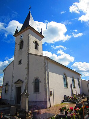
Pont-à-Mousson
Commune in Grand Est, France
Distance: Approx. 422 meters
Latitude and longitude: 48.9053,6.0547
Pont-à-Mousson (French pronunciation: [pɔ̃.t‿a.musɔ̃]) is a commune in the Meurthe-et-Moselle department in north-eastern France. Its inhabitants are known as Mussipontains in French. It is an industrial town (mainly steel industry), situated on the river Moselle.
Atton
Commune in Grand Est, France
Distance: Approx. 3005 meters
Latitude and longitude: 48.8914,6.0914
Atton (French pronunciation: [atɔ̃]) is a commune in the Meurthe-et-Moselle department in northeastern France.
Mousson
Commune in Grand Est, France
Distance: Approx. 1561 meters
Latitude and longitude: 48.9058,6.08
Mousson (French pronunciation: [musɔ̃] ) is a commune in the Meurthe-et-Moselle department in north-eastern France. The village lies on a hilltop, adjacent to the east of Pont-à-Mousson.

Blénod-lès-Pont-à-Mousson
Commune in Grand Est, France
Distance: Approx. 2786 meters
Latitude and longitude: 48.8839,6.0481
Blénod-lès-Pont-à-Mousson (French pronunciation: [bleno lɛ pɔ̃.t‿a musɔ̃], literally Blénod near Pont-à-Mousson) is a commune in the Meurthe-et-Moselle department in northeastern France.

Lesménils
Commune in Grand Est, France
Distance: Approx. 4028 meters
Latitude and longitude: 48.9322,6.0997
Lesménils (French pronunciation: [lemenil]) is a commune in the Meurthe-et-Moselle department in north-eastern France.

Maidières
Commune in Grand Est, France
Distance: Approx. 1775 meters
Latitude and longitude: 48.8997,6.0381
Maidières (French pronunciation: [mɛdjɛʁ]) is a commune in the Meurthe-et-Moselle department in north-eastern France.

Montauville
Commune in Grand Est, France
Distance: Approx. 2808 meters
Latitude and longitude: 48.9017,6.0217
Montauville (French pronunciation: [mɔ̃tovil]) is a commune in the Meurthe-et-Moselle department in north-eastern France. It is the location of the French Le Pétant military cemetery, with WWI casualties of the Battle of Bois-le-Prêtre, and French WWII soldiers which died in German captivity.

Norroy-lès-Pont-à-Mousson
Commune in Grand Est, France
Distance: Approx. 3709 meters
Latitude and longitude: 48.935,6.0294
Norroy-lès-Pont-à-Mousson (French pronunciation: [nɔʁwa lɛ pɔ̃.t‿a musɔ̃], literally Norroy near Pont-à-Mousson) is a commune in the Meurthe-et-Moselle department in north-eastern France.
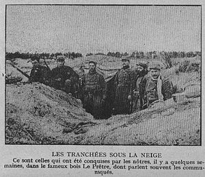
Bois-le-Prêtre fighting
Distance: Approx. 4165 meters
Latitude and longitude: 48.915,6.003
Bois-le-Prêtre fighting (Priest's Wood, Priesterwald in German) was an engagement in the First World War between September 1914 and July 1915, involving the French 73rd Division and the 128th Division (the Wolves of Bois-le-Prêtre) and the German 121st Division.

Lorraine Regional Natural Park
Regional natural park of France
Distance: Approx. 2294 meters
Latitude and longitude: 48.88967,6.04428
Lorraine Regional Natural Park (French: Parc naturel régional de Lorraine) is a protected area of pastoral countryside in the Grand Est region of northeastern France, in the historic region of Lorraine. The park covers a total area of 205,000 hectares (510,000 acres). The parkland is split in two non-contiguous parcels of land between the cities of Metz and Nancy, and spans the three departments of Meuse, Meurthe-et-Moselle, and Moselle.

Château de Mousson
Distance: Approx. 1406 meters
Latitude and longitude: 48.90472222,6.0775
The Château de Mousson is a ruined castle in the commune of Mousson in the Meurthe-et-Moselle département of France. Until the 13th century, the Château de Mousson was the residence of the Counts of Mousson. On the summit of a hill, it overlooked the valleys of the Seille and the Moselle.
Canton of Pont-à-Mousson
Canton in Grand Est, France
Distance: Approx. 1094 meters
Latitude and longitude: 48.9,6.05
The canton of Pont-à-Mousson is an administrative division of the Meurthe-et-Moselle department, northeastern France. Its borders were modified at the French canton reorganisation which came into effect in March 2015. Its seat is in Pont-à-Mousson.
Weather in this IP's area
clear sky
18 Celsius
18 Celsius
16 Celsius
19 Celsius
1025 hPa
88 %
1025 hPa
1003 hPa
10000 meters
1.54 m/s
06:03:55
21:20:22