Country:
 France
Region:
City:
Latitude and Longitude:
Time Zone:
Postal Code:
IP information under different IP Channel
ip-api
Country
Region
City
ASN
Time Zone
ISP
Blacklist
Proxy
Latitude
Longitude
Postal
Route
IPinfo
Country
Region
City
ASN
Time Zone
ISP
Blacklist
Proxy
Latitude
Longitude
Postal
Route
MaxMind
Country
Region
City
ASN
Time Zone
ISP
Blacklist
Proxy
Latitude
Longitude
Postal
Route
Luminati
Country
FRRegion
naq
City
bruges
ASN
Time Zone
Europe/Paris
ISP
ADISTA SAS
Latitude
Longitude
Postal
db-ip
Country
Region
City
ASN
Time Zone
ISP
Blacklist
Proxy
Latitude
Longitude
Postal
Route
ipdata
Country
Region
City
ASN
Time Zone
ISP
Blacklist
Proxy
Latitude
Longitude
Postal
Route
Popular places and events near this IP address
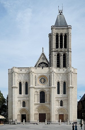
Basilica of Saint-Denis
Basilica in Saint-Denis, France
Distance: Approx. 569 meters
Latitude and longitude: 48.93555556,2.35972222
The Basilica of Saint-Denis (French: Basilique royale de Saint-Denis, now formally known as the Basilique-cathédrale de Saint-Denis) is a large former medieval abbey church and present cathedral in the commune of Saint-Denis, a northern suburb of Paris. The building is of singular importance historically and architecturally as its choir, completed in 1144, is widely considered the first structure to employ all of the elements of Gothic architecture. The basilica became a place of pilgrimage and a necropolis containing the tombs of the kings of France, including nearly every king from the 10th century to Louis XVIII in the 19th century.

Basilique de Saint-Denis station
Metro station in Paris, France
Distance: Approx. 682 meters
Latitude and longitude: 48.93806,2.36083
Basilique de Saint-Denis (French pronunciation: [bazilik də sɛ̃ dəni]) is a Paris Métro station on line 13 in the town centre of Saint-Denis, north of Paris. It connects with tram line 1 at two nearby stops at Basilique de Saint-Denis and Marché de Saint-Denis.

Arrondissement of Saint-Denis, Seine-Saint-Denis
Arrondissement in Île-de-France, France
Distance: Approx. 755 meters
Latitude and longitude: 48.93361111,2.35638889
The arrondissement of Saint-Denis (French: arrondissement de Saint-Denis) is an arrondissement (district) of France in the Seine-Saint-Denis department, Île-de-France. It has 9 communes. Its population is 443,169 (2019), and its area is 47.4 km2 (18.3 sq mi).
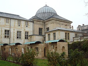
Musée d'art et d'histoire de Saint-Denis
Distance: Approx. 764 meters
Latitude and longitude: 48.93222222,2.35638889
The Museum of Art and History (in French: Musée d'Art et d'Histoire Paul-Éluard), is a museum located in the historical town of Saint-Denis, France, in the northern outskirts of Paris.

Roman Catholic Diocese of Saint-Denis
Catholic diocese in France
Distance: Approx. 669 meters
Latitude and longitude: 48.935,2.35793
The Diocese of Saint-Denis in Île-de-France (Latin: Dioecesis Sancti Dionysii in Francia; French: Diocèse de Saint-Denis-en-France) is a Latin diocese of the Catholic Church in France. Erected in 1966 by Pope Paul VI, the diocese was split off from the Archdiocese of Paris and the Diocese of Versailles. Its territory comprises the department of Seine-Saint-Denis.

Saint-Denis–Porte de Paris station
Metro station in Paris, France
Distance: Approx. 734 meters
Latitude and longitude: 48.93028,2.35778
Saint-Denis–Porte de Paris (French pronunciation: [sɛ̃ dəni pɔʁt də paʁi]) is a station on Line 13 of the Paris Métro in the commune of Saint-Denis.
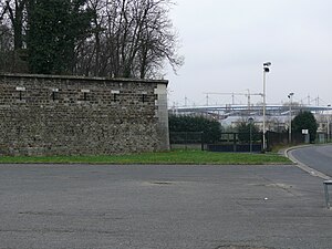
Fort de l'Est
Distance: Approx. 506 meters
Latitude and longitude: 48.93055556,2.37222222
Fort de l'Est is a military strong point designed to protect Paris. It was built between 1841 and 1843 in Saint-Denis at the direction of French prime minister Adolphe Thiers, and was part of an immense defensive belt comprising 17 detached forts and the Thiers Wall surrounding Paris. The evolution of artillery quickly made these fortifications obsolete.

Saint-Denis, Seine-Saint-Denis
Subprefecture and commune in Île-de-France, France
Distance: Approx. 970 meters
Latitude and longitude: 48.9356,2.3539
Saint-Denis (, French: [sɛ̃d(ə)ni] ) is a commune in the northern suburbs of Paris, France. It is located 9.4 km (5.8 mi) from the centre of Paris. Saint-Denis is the second most populated suburb of Paris (after Boulogne-Billancourt), with a population of 113,116 at the 2020 census.
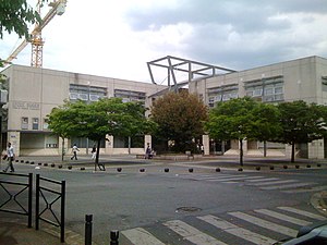
Lycée Suger
Public high school
Distance: Approx. 457 meters
Latitude and longitude: 48.9292,2.3663
Lycée Suger is a senior high school/sixth-form college in the Le Franc-Moisin area of Saint-Denis, Seine-Saint-Denis, France, within the Paris metropolitan area. The school opened in 1994. The teachers went on strike in September 2016.
Canton of Saint-Denis-2, Seine-Saint-Denis
Distance: Approx. 892 meters
Latitude and longitude: 48.94,2.36
The canton of Saint-Denis-2 is an administrative division of the Seine-Saint-Denis department in the Île-de-France region, northern France. It was created at the French canton reorganisation which came into effect in March 2015. Its seat is in Saint-Denis.
Ensemble Scolaire Jean-Baptiste de La Salle - Notre-Dame de la Compassion
Public high school
Distance: Approx. 864 meters
Latitude and longitude: 48.93285,2.3549
Ensemble Scolaire Jean-Baptiste de La Salle - Notre-Dame de la Compassion is a private Catholic school in Saint-Denis, Seine-Saint-Denis, France, in the Paris metropolitan area. It serves primary school through sixth-form college/senior high school (lycée). As of 2014 about 2,400 students attend this school.

Tomb of Louis XII and Anne of Brittany
16th-century royal funerary monument
Distance: Approx. 572 meters
Latitude and longitude: 48.9356,2.3597
The Tomb of Louis XII and Anne of Brittany is a large and complex silver-gilt and marble sculptured 16th century funerary monument. Its design and build are usually attributed to the Juste brothers although the work of several other hands can be distinguished. Designed for and installed at the Saint-Denis Basilica, France, it was commissioned in 1515 in memory of Louis XII (d.
Weather in this IP's area
clear sky
21 Celsius
21 Celsius
20 Celsius
23 Celsius
1025 hPa
68 %
1025 hPa
1021 hPa
10000 meters
2.57 m/s
90 degree
06:18:37
21:35:12