Country:
Region:
City:
Latitude and Longitude:
Time Zone:
Postal Code:
IP information under different IP Channel
ip-api
Country
Region
City
ASN
Time Zone
ISP
Blacklist
Proxy
Latitude
Longitude
Postal
Route
IPinfo
Country
Region
City
ASN
Time Zone
ISP
Blacklist
Proxy
Latitude
Longitude
Postal
Route
MaxMind
Country
Region
City
ASN
Time Zone
ISP
Blacklist
Proxy
Latitude
Longitude
Postal
Route
Luminati
Country
Region
naq
City
bruges
ASN
Time Zone
Europe/Paris
ISP
ADISTA SAS
Latitude
Longitude
Postal
db-ip
Country
Region
City
ASN
Time Zone
ISP
Blacklist
Proxy
Latitude
Longitude
Postal
Route
ipdata
Country
Region
City
ASN
Time Zone
ISP
Blacklist
Proxy
Latitude
Longitude
Postal
Route
Popular places and events near this IP address

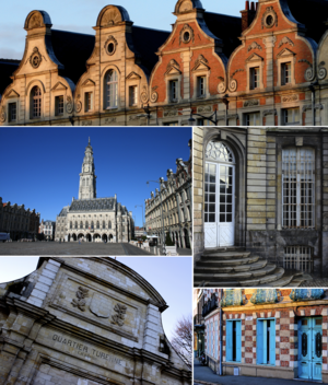
Arras
Prefecture and commune in Hauts-de-France, France
Distance: Approx. 1940 meters
Latitude and longitude: 50.292,2.78
Arras ( ARR-əs, French: [aʁɑs] ; Picard: Aros; historical Dutch: Atrecht [ˈaːtrɛxt] ) is the prefecture of the Pas-de-Calais department, which forms part of the region of Hauts-de-France; before the reorganization of 2014 it was in Nord-Pas-de-Calais. The historic centre of the Artois region, with a Baroque town square, Arras is in northern France at the confluence of the rivers Scarpe and Crinchon. The Arras plain is on a large chalk plateau bordered on the north by the Marqueffles fault, on the southwest by the Artois and Ternois hills, and on the south by the slopes of Beaufort-Blavincourt.

Battle of Arras (1654)
1654 clash between the French and the Spanish
Distance: Approx. 1938 meters
Latitude and longitude: 50.2897,2.7808
The Battle of Arras, fought on 25 August 1654, was a victory of a French army under Turenne against a Spanish army commanded by Don Ferdinand de Salis and the Prince de Condé. The place, held by a French garrison, was besieged by the Spaniards under the Great Condé. A relief army under Turenne, d'Hocquincourt and de la Ferté attacked the Spanish lines and totally routed them with a loss of at least 7,000 men.
Saint-Nicolas, Pas-de-Calais
Commune in Hauts-de-France, France
Distance: Approx. 2267 meters
Latitude and longitude: 50.3031,2.7781
Saint-Nicolas (French pronunciation: [sɛ̃ nikɔla]; West Flemish: Sint-Niklaas) or Saint-Nicolas-lez-Arras ([sɛ̃ nikɔla lɛ.z‿aʁas], literally Saint-Nicolas near Arras) is a commune in the Pas-de-Calais department in the Hauts-de-France region of France.
Saint-Laurent-Blangy
Commune in Hauts-de-France, France
Distance: Approx. 987 meters
Latitude and longitude: 50.3031,2.8036
Saint-Laurent-Blangy (French pronunciation: [sɛ̃ loʁɑ̃ blɑ̃ʒi]) is a commune in the Pas-de-Calais department in the Hauts-de-France region of France.
Tilloy-lès-Mofflaines
Commune in Hauts-de-France, France
Distance: Approx. 2058 meters
Latitude and longitude: 50.2772,2.8172
Tilloy-lès-Mofflaines (French pronunciation: [tilwa lɛ mɔflɛn]) is a commune in the Pas-de-Calais department in the Hauts-de-France region of France.
University of Artois
Public university based in northern France
Distance: Approx. 1579 meters
Latitude and longitude: 50.283,2.794
The University of Artois (French: Université d'Artois) is a public university situated in the Nord and Pas-de-Calais departments of northern France. It is situated on 5 campuses in Arras, Béthune, Douai, Lens and Liévin. The University of Artois is a member of the European Doctoral College Lille-Nord-Pas de Calais and the University of Lille Nord de France group of universities.
Canton of Arras-Nord
Former canton in Hauts-de-France, France
Distance: Approx. 673 meters
Latitude and longitude: 50.3,2.80305556
The Canton of Arras-Nord is a former canton situated in the department of the Pas-de-Calais and the Nord-Pas-de-Calais region of northern France. It was disbanded following the French canton reorganisation which came into effect in March 2015. It consisted of 4 communes, which joined the canton of Arras-2 in 2015.
Canton of Arras-Ouest
Former canton in Hauts-de-France, France
Distance: Approx. 2097 meters
Latitude and longitude: 50.2833,2.7833
The Canton of Arras-Ouest is a former canton situated in the department of the Pas-de-Calais and in the Nord-Pas-de-Calais region of northern France. It was disbanded following the French canton reorganisation which came into effect in March 2015. The canton comprised part of the commune of Arras.

Communauté urbaine d'Arras
Communauté urbaine in Hauts-de-France, France
Distance: Approx. 1984 meters
Latitude and longitude: 50.29,2.78
The Communauté urbaine d'Arras is the communauté urbaine, an intercommunal structure, centred on the city of Arras. It is located in the Pas-de-Calais department, in the Hauts-de-France region, northern France. It was created in January 1998, replacing the previous district urbain d'Arras.
Arras station
French railway station
Distance: Approx. 2008 meters
Latitude and longitude: 50.2869,2.781391
Arras station (French: Gare d'Arras) is a railway station serving the town Arras, Pas-de-Calais department, northern France. This station, which opened in 1846, is located on the Paris–Lille railway and Arras-Dunkirk railway and accessible from LGV Nord.
Hôtel de Ville, Arras
Distance: Approx. 2153 meters
Latitude and longitude: 50.2911,2.7772
The Hôtel de Ville (French pronunciation: [otɛl də vil], City Hall) is a historic building in Arras, Pas-de-Calais, northern France. It was built in the 16th century, and completed in 1517. It was restored in the 19th century, and re-dedicated on 26 August 1867 by Emperor Napoleon III. It was then almost completely destroyed in World War I and rebuilt during the 1920s, using some modern materials where practicable.
Canton of Arras-2
Canton of France
Distance: Approx. 1984 meters
Latitude and longitude: 50.29,2.78
The canton of Arras-2 is an administrative division of the Pas-de-Calais department, in northern France. It was created at the French canton reorganisation which came into effect in March 2015. Its seat is in Arras.
Weather in this IP's area
broken clouds
23 Celsius
23 Celsius
21 Celsius
24 Celsius
1026 hPa
53 %
1026 hPa
1018 hPa
10000 meters
1.05 m/s
0.91 m/s
96 degree
56 %
06:11:47
21:38:31


