Country:
 France
Region:
City:
Latitude and Longitude:
Time Zone:
Postal Code:
IP information under different IP Channel
ip-api
Country
Region
City
ASN
Time Zone
ISP
Blacklist
Proxy
Latitude
Longitude
Postal
Route
IPinfo
Country
Region
City
ASN
Time Zone
ISP
Blacklist
Proxy
Latitude
Longitude
Postal
Route
MaxMind
Country
Region
City
ASN
Time Zone
ISP
Blacklist
Proxy
Latitude
Longitude
Postal
Route
Luminati
Country
FRRegion
naq
City
bruges
ASN
Time Zone
Europe/Paris
ISP
ADISTA SAS
Latitude
Longitude
Postal
db-ip
Country
Region
City
ASN
Time Zone
ISP
Blacklist
Proxy
Latitude
Longitude
Postal
Route
ipdata
Country
Region
City
ASN
Time Zone
ISP
Blacklist
Proxy
Latitude
Longitude
Postal
Route
Popular places and events near this IP address
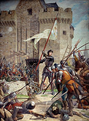
Siege of Orléans
Turning point in the Hundred Years' War
Distance: Approx. 376 meters
Latitude and longitude: 47.9025,1.9089
The siege of Orléans (12 October 1428 – 8 May 1429) marked a turning point of the Hundred Years' War between France and England. The siege took place at the pinnacle of English power during the later stages of the war, but was repulsed by French forces inspired by the arrival of Joan of Arc. The French would then regain the initiative in the conflict and began to recapture territories previously occupied by the English.

Orléans
Prefecture and commune in France
Distance: Approx. 383 meters
Latitude and longitude: 47.9025,1.909
Orléans (UK: ; US: , French: [ɔʁleɑ̃] ) is a city in north-central France, about 120 kilometres (74 miles) southwest of Paris. It is the prefecture of the department of Loiret and of the region of Centre-Val de Loire. Orléans is located on the river Loire nestled in the heart of the Loire Valley, classified as a World Heritage Site, where the river curves south towards the Massif Central.
First Council of Orléans
Synod
Distance: Approx. 497 meters
Latitude and longitude: 47.90305556,1.91055556
The First Council of Orléans was convoked by Clovis I, King of the Franks, in 511. Clovis called for this synod four years after his victory over the Visigoths under Alaric II at the Battle of Vouillé in 507. The council was attended by thirty-two bishops, including four metropolitans, from across Gaul, and together they passed thirty-one decrees.

Second Battle of Orléans
Franco-Prussian War, 3-4 Dec 1870
Distance: Approx. 383 meters
Latitude and longitude: 47.9025,1.909
The Second Battle of Orléans was fought during the Franco-Prussian War of 1870. It took place on December 3 and 4, 1870 and was part of the Loire Campaign. The Germans recaptured Orléans, which had been retaken by the French on November 11, 1870 after the Battle of Coulmiers, and divided the French Army of the Loire in two.

Orléans Cathedral
Roman catholic church in Orléans, France
Distance: Approx. 495 meters
Latitude and longitude: 47.90166667,1.91027778
Orléans Cathedral (French: Basilique Cathédrale Sainte-Croix d'Orléans) is a Roman Catholic church located in the city of Orléans, France. The cathedral is the seat of the Bishop of Orléans. It was originally built from 1278 to 1329.
Cenabum
Ancient capital city of the Carnutes in Gaul
Distance: Approx. 383 meters
Latitude and longitude: 47.9025,1.909
Cenabum, Gaul (sometimes written Cenabaum or Genabum) was the name of the capital city of the Carnutes, located near the present French city of Orléans. Cenabum was an oppidum and a thriving commercial town on the Loire river. In 52 BC, during the Gallic Wars, the town was taken by Roman general Julius Caesar and integrated into the Roman province of Gallia Lugdunensis.
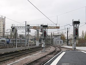
Orléans station
Railway station in France
Distance: Approx. 549 meters
Latitude and longitude: 47.9078,1.9047
Orléans station (French: Gare d'Orléans) is a railway station serving the city Orléans, Loiret department, central France. It is situated on the Paris–Bordeaux railway. The Gare d'Orléans is a terminus station, and therefore TGV and most other long-distance trains only serve the nearby Les Aubrais station.

Musée des Beaux-Arts d'Orléans
Museum in Orléans, France
Distance: Approx. 424 meters
Latitude and longitude: 47.9025881,1.9095664
The Musée des beaux-arts d'Orléans is a museum in the city of Orléans in the Loiret department and the Centre-Val de Loire region in France. Founded in 1797, it is one of France's oldest provincial museums. Its collections cover European arts from the 15th to 20th century.
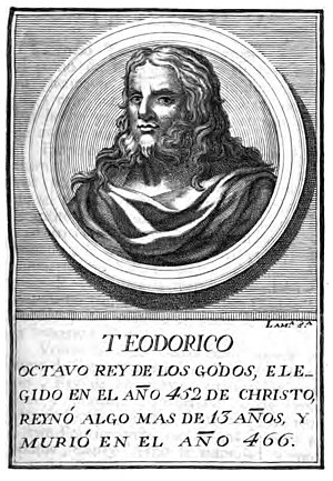
Battle of Orleans (463)
463 battle
Distance: Approx. 383 meters
Latitude and longitude: 47.9025,1.909
The Battle of Orléans took place in the year 463, between the Kingdom of Soissons, under the command of the magister militum Aegidius, and the Visigoths, commanded by the Visigoth King Theodoric II and his brother Federico.
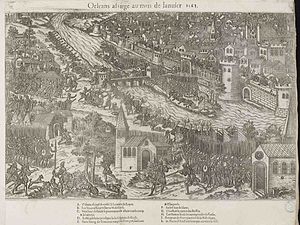
Siege of Orléans (1563)
Battle of the French Wars of Religion
Distance: Approx. 394 meters
Latitude and longitude: 47.902,1.909
The siege of Orléans was the final key military engagement of the first French War of Religion. Having lost the Battle of Dreux the rebel Huguenots fell back with their remaining forces to the city. François, Duke of Guise, the only non captive royal commander, moved to lay siege to the town, hoping its capitulation would bring about a total victory for the crowns forces.
Canton of Orléans-1
Distance: Approx. 435 meters
Latitude and longitude: 47.9,1.9
The canton of Orléans-1 is an administrative division of the Loiret department, central France. It was created at the French canton reorganisation which came into effect in March 2015. Its seat is in Orléans.
Canton of Orléans-4
Distance: Approx. 558 meters
Latitude and longitude: 47.9,1.91
The canton of Orléans-4 is an administrative division of the Loiret department, central France. It was created at the French canton reorganisation which came into effect in March 2015. Its seat is in Orléans.
Weather in this IP's area
clear sky
20 Celsius
20 Celsius
19 Celsius
21 Celsius
1024 hPa
66 %
1024 hPa
1010 hPa
10000 meters
5.14 m/s
80 degree
06:24:05
21:33:26