Country:
 France
Region:
City:
Latitude and Longitude:
Time Zone:
Postal Code:
IP information under different IP Channel
ip-api
Country
Region
City
ASN
Time Zone
ISP
Blacklist
Proxy
Latitude
Longitude
Postal
Route
IPinfo
Country
Region
City
ASN
Time Zone
ISP
Blacklist
Proxy
Latitude
Longitude
Postal
Route
MaxMind
Country
Region
City
ASN
Time Zone
ISP
Blacklist
Proxy
Latitude
Longitude
Postal
Route
Luminati
Country
FRRegion
naq
City
bruges
ASN
Time Zone
Europe/Paris
ISP
ADISTA SAS
Latitude
Longitude
Postal
db-ip
Country
Region
City
ASN
Time Zone
ISP
Blacklist
Proxy
Latitude
Longitude
Postal
Route
ipdata
Country
Region
City
ASN
Time Zone
ISP
Blacklist
Proxy
Latitude
Longitude
Postal
Route
Popular places and events near this IP address

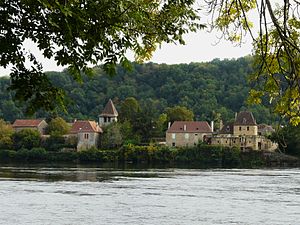
Lalinde
Commune in Nouvelle-Aquitaine, France
Distance: Approx. 664 meters
Latitude and longitude: 44.8378,0.7389
Lalinde (French pronunciation: [lalɛ̃d]; Occitan: La Linda) is a commune in the Dordogne department in Nouvelle-Aquitaine in southwestern France. It lies on the river Dordogne and was enclosed within fortified walls of which little remains today. Lalinde station and Couze station have rail connections to Bordeaux, Bergerac and Sarlat-la-Canéda.
Pontours
Commune in Nouvelle-Aquitaine, France
Distance: Approx. 2527 meters
Latitude and longitude: 44.8369,0.7628
Pontours is a commune in the Dordogne department in Nouvelle-Aquitaine in southwestern France.

Bayac
Commune in Nouvelle-Aquitaine, France
Distance: Approx. 3553 meters
Latitude and longitude: 44.8044,0.7269
Bayac (French pronunciation: [bajak]; Occitan: Baiac) is a commune in the Dordogne department in southwestern France.

Baneuil
Commune in Nouvelle-Aquitaine, France
Distance: Approx. 3755 meters
Latitude and longitude: 44.8539,0.6903
Baneuil (French pronunciation: [banœj]; Occitan: Banuèlh) is a commune in the Dordogne department in southwestern France.

Couze-et-Saint-Front
Commune in Nouvelle-Aquitaine, France
Distance: Approx. 2091 meters
Latitude and longitude: 44.8281,0.7069
Couze-et-Saint-Front (French pronunciation: [kuz e sɛ̃ fʁɔ̃]; Occitan: Cosa e Sent Front) is a commune in the Dordogne department in Nouvelle-Aquitaine in southwestern France.
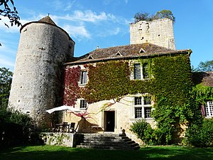
Château de Baneuil
Distance: Approx. 3696 meters
Latitude and longitude: 44.8525,0.69
The Château de Baneuil is a château in Baneuil, Dordogne, Nouvelle-Aquitaine, France.
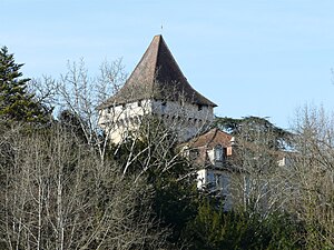
Château de Bayac
Château in Bayac, Dordogne, France
Distance: Approx. 3600 meters
Latitude and longitude: 44.80388889,0.72888889
The Château de Bayac is a château in Bayac, Dordogne, Nouvelle-Aquitaine, France.

Lalinde station
Distance: Approx. 1002 meters
Latitude and longitude: 44.83916667,0.74277778
Lalinde is a railway station in Lalinde, Nouvelle-Aquitaine, France. The station is located on the Libourne - Le Buisson railway line.

Couze station
Railway station in Nouvelle-Aquitaine, France
Distance: Approx. 2146 meters
Latitude and longitude: 44.83638889,0.70361111
Couze is a railway station in Lalinde, Nouvelle-Aquitaine, France. The station is located on the Libourne - Le Buisson railway line.

Château de Lalinde
Distance: Approx. 577 meters
Latitude and longitude: 44.83555556,0.73805556
The Château de Lalinde is a château, developed from a 13th-century castle, in the commune of Lalinde in the Dordogne département of France. It is known locally as le château de la Bastide.
Canton of Lalinde
Distance: Approx. 840 meters
Latitude and longitude: 44.84,0.74
The canton of Lalinde is an administrative division of the Dordogne department, southwestern France. Its borders were modified at the French canton reorganisation which came into effect in March 2015. Its seat is in Lalinde.

Couze (Dordogne)
River in France
Distance: Approx. 2248 meters
Latitude and longitude: 44.8315,0.7031
The Couze (French pronunciation: [kuz]) is a 30.1-kilometre-long (18.7 mi) tributary of the Dordogne in France, with its source between Fongalop and Bouillac, and its mouth in Port-de-Couze. The lower half of the stream runs between limestone cliffs. The main villages along the river and its small tributaries are Beaumont-du-Périgord, Montferrand-du-Périgord, Couze-et-Saint-Front and Saint-Avit-Sénieur.
Weather in this IP's area
clear sky
31 Celsius
35 Celsius
31 Celsius
32 Celsius
1018 hPa
62 %
1018 hPa
1013 hPa
10000 meters
2.06 m/s
60 degree
06:38:38
21:28:16