Country:
Region:
City:
Latitude and Longitude:
Time Zone:
Postal Code:
IP information under different IP Channel
ip-api
Country
Region
City
ASN
Time Zone
ISP
Blacklist
Proxy
Latitude
Longitude
Postal
Route
IPinfo
Country
Region
City
ASN
Time Zone
ISP
Blacklist
Proxy
Latitude
Longitude
Postal
Route
MaxMind
Country
Region
City
ASN
Time Zone
ISP
Blacklist
Proxy
Latitude
Longitude
Postal
Route
Luminati
Country
Region
naq
City
bruges
ASN
Time Zone
Europe/Paris
ISP
ADISTA SAS
Latitude
Longitude
Postal
db-ip
Country
Region
City
ASN
Time Zone
ISP
Blacklist
Proxy
Latitude
Longitude
Postal
Route
ipdata
Country
Region
City
ASN
Time Zone
ISP
Blacklist
Proxy
Latitude
Longitude
Postal
Route
Popular places and events near this IP address

Pommeuse
Commune in Île-de-France, France
Distance: Approx. 3892 meters
Latitude and longitude: 48.8172,3.0172
Pommeuse (French pronunciation: [pɔmøz] ) is a commune in the Seine-et-Marne department in the Île-de-France region in north-central France.

Canton of Coulommiers
Canton in Île-de-France, France
Distance: Approx. 2854 meters
Latitude and longitude: 48.8075,3.04305556
The canton of Coulommiers is a French administrative division, located in the arrondissement of Meaux, in the Seine-et-Marne département (Île-de-France région).
Faremoutiers Abbey
Distance: Approx. 3172 meters
Latitude and longitude: 48.80194444,2.9975
Faremoutiers Abbey (French: Abbaye Notre-Dame de Faremoutiers) was an important Merovingian Benedictine nunnery (re-established in the 20th century) in the present Seine-et-Marne department of France. It formed an important link between the Merovingian Frankish Empire and the southern Anglo-Saxon kingdoms of Kent and East Anglia.

Faremoutiers
Commune in Île-de-France, France
Distance: Approx. 3030 meters
Latitude and longitude: 48.79944444,2.99694444
Faremoutiers (French pronunciation: [faʁmutje] ) is a commune in the Seine-et-Marne department in the Île-de-France region in north-central France.
Mauperthuis
Commune in Île-de-France, France
Distance: Approx. 1770 meters
Latitude and longitude: 48.7686,3.0394
Mauperthuis (French pronunciation: [mopɛʁtɥi] ) is a commune in the Seine-et-Marne department in the Île-de-France region in north-central France. The village is famous for having produced five Musketeers including d'Artagnan, who was made famous in Alexandre Dumas, père's books. The ruined Château d'Artagnan still exists.

Mouroux
Commune in Île-de-France, France
Distance: Approx. 4369 meters
Latitude and longitude: 48.8222,3.0381
Mouroux (French pronunciation: [muʁu] ) is a commune in the Seine-et-Marne department in the Île-de-France region in north-central France.
Saint-Augustin, Seine-et-Marne
Commune in Île-de-France, France
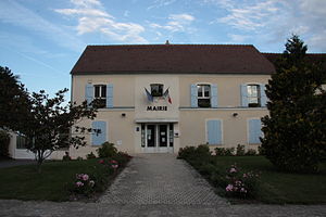
Distance: Approx. 227 meters
Latitude and longitude: 48.7853,3.0308
Saint-Augustin (French pronunciation: [sɛ̃.t‿oɡystɛ̃] ) is a commune in the Seine-et-Marne department in the Île-de-France region in north-central France.
Saints, Seine-et-Marne
Part of Beautheil-Saints in Île-de-France, France
Distance: Approx. 3138 meters
Latitude and longitude: 48.7586,3.0508
Saints (French pronunciation: [sɛ̃] ) is a former commune in the Seine-et-Marne department in the Île-de-France region in north-central France. On 1 January 2019, it was merged into the new commune Beautheil-Saints.
Communauté de communes de la Brie des Moulins
Former communauté de communes in Île-de-France, France
Distance: Approx. 3810 meters
Latitude and longitude: 48.8162,3.0159
The Communauté de communes de la Brie des Moulins is a former federation of municipalities (communauté de communes) in the Seine-et-Marne département and in the Île-de-France région of France. It was created in August 1997. It was merged into the Communauté de communes du Pays de Coulommiers in January 2017.
Aubetin
River in France
Distance: Approx. 3966 meters
Latitude and longitude: 48.81555556,3.00722222
The Aubetin is a 61.2-kilometre (38.0 mi) long river in the Marne and Seine-et-Marne départements, northeastern France. Its source is at Les Essarts-le-Vicomte, 20 kilometres (12 mi) northeast of Nogent-sur-Seine. It flows generally west-northwest.

Saints Aerodrome
Distance: Approx. 2739 meters
Latitude and longitude: 48.76777778,3.05916667
Saints Aerodrome, was a temporary World War I airfield in France. It was located 0.7 miles (1.1 km) North of Saints, in the Île-de-France region in north-central France.

Beautheil-Saints
Commune in Île-de-France, France
Distance: Approx. 3138 meters
Latitude and longitude: 48.7586,3.0508
Beautheil-Saints (French pronunciation: [botɛj sɛ̃]) is a commune in the Seine-et-Marne department in the Île-de-France region in north-central France. It was established on 1 January 2019 by merger of the former communes of Saints (the seat) and Beautheil.
Weather in this IP's area
broken clouds
15 Celsius
15 Celsius
14 Celsius
16 Celsius
1025 hPa
99 %
1025 hPa
1011 hPa
10000 meters
2.07 m/s
3.04 m/s
62 degree
81 %
06:16:30
21:32:01


