Country:
 France
Region:
City:
Latitude and Longitude:
Time Zone:
Postal Code:
IP information under different IP Channel
ip-api
Country
Region
City
ASN
Time Zone
ISP
Blacklist
Proxy
Latitude
Longitude
Postal
Route
IPinfo
Country
Region
City
ASN
Time Zone
ISP
Blacklist
Proxy
Latitude
Longitude
Postal
Route
MaxMind
Country
Region
City
ASN
Time Zone
ISP
Blacklist
Proxy
Latitude
Longitude
Postal
Route
Luminati
Country
FRRegion
naq
City
bruges
ASN
Time Zone
Europe/Paris
ISP
ADISTA SAS
Latitude
Longitude
Postal
db-ip
Country
Region
City
ASN
Time Zone
ISP
Blacklist
Proxy
Latitude
Longitude
Postal
Route
ipdata
Country
Region
City
ASN
Time Zone
ISP
Blacklist
Proxy
Latitude
Longitude
Postal
Route
Popular places and events near this IP address
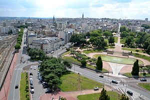
Limoges
Prefecture and commune in Nouvelle-Aquitaine, France
Distance: Approx. 550 meters
Latitude and longitude: 45.8353,1.2625
Limoges (, US also , French: [limɔʒ] ; Occitan: Lemòtges, locally Limòtges [liˈmɔdzes]) is a city and commune, and the prefecture of the Haute-Vienne department in west-central France. It was the administrative capital of the former Limousin region. Situated on the first western foothills of the Massif Central, Limoges is crossed by the river Vienne, of which it was originally the first ford crossing point.

Arrondissement of Limoges
Arrondissement in Nouvelle-Aquitaine, France
Distance: Approx. 635 meters
Latitude and longitude: 45.83333333,1.25
The arrondissement of Limoges is an arrondissement of France in the Haute-Vienne department in the Nouvelle-Aquitaine region. It has 108 communes. Its population is 297,957 (2016), and its area is 2,944.8 km2 (1,137.0 sq mi).

Roman Catholic Diocese of Limoges
Catholic diocese in France
Distance: Approx. 666 meters
Latitude and longitude: 45.82805556,1.26472222
The Diocese of Limoges (Latin: Dioecesis Lemovicensis; French: Diocèse de Limoges) is a Latin Church diocese of the Catholic Church in France. The diocese comprises the départments of Haute-Vienne and Creuse. After the Concordat of 1801, the See of Limoges lost twenty-four parishes from the district of Nontron which were annexed to the Diocese of Périgueux, and forty-four from the district of Confolens, transferred to the Diocese of Angoulême; but until 1822 it included the entire ancient Diocese of Tulle, when the latter was reorganized.
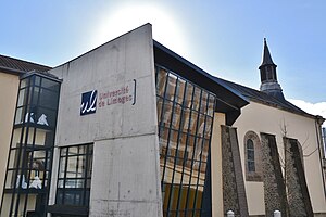
University of Limoges
Distance: Approx. 580 meters
Latitude and longitude: 45.8264,1.2583
The University of Limoges (Université de Limoges) is a French public university, based in Limoges. Its chancellor is the rector of the Academy of Limoges (an administrative district in France for education and research). It counts more than 16,000 students and near 1,000 scholars and researchers.

Siege of Limoges
Component of the Hundred Years' War
Distance: Approx. 550 meters
Latitude and longitude: 45.8353,1.2625
The town of Limoges had been under English control but in August 1370 it surrendered to the French, opening its gates to the Duke of Berry. The siege of Limoges was laid by the English army led by Edward the Black Prince in the second week in September. On 19 September, the town was taken by storm, followed by much destruction and the deaths of numerous civilians.
Limoges Conservatory
Distance: Approx. 131 meters
Latitude and longitude: 45.8325,1.25888889
Limoges Conservatory or Conservatoire à rayonnement régional de Limoges is a musical conservatory in Limoges, France. As of 2012 it had an enrollment of 2000 students and 79 teachers.
Canton of Limoges-6
Canton of France
Distance: Approx. 631 meters
Latitude and longitude: 45.83,1.25
The canton of Limoges-6 is an administrative division of the Haute-Vienne department, western France. It was created at the French canton reorganisation which came into effect in March 2015. Its seat is in Limoges.

Limoges Métropole
Communauté urbaine in Nouvelle-Aquitaine, France
Distance: Approx. 247 meters
Latitude and longitude: 45.83,1.26
Communauté urbaine Limoges Métropole is the communauté urbaine, an intercommunal structure, centred on the city of Limoges. It is located in the Haute-Vienne department, in the Nouvelle-Aquitaine region, southwestern France. It was created in November 2002 as the Communauté d'agglomération Limoges Métropole, which was transformed into a communauté urbaine on 1 January 2019.

Church of St. Pierre du Queyroix
Church in Limoges, France
Distance: Approx. 305 meters
Latitude and longitude: 45.83111111,1.26166667
The Church of St. Pierre du Queyroix (French: église Saint-Pierre-du-Queyroix; Limousin Occitan: egleisa de Sant Peire dau Cairoi) is one of the main churches of Limoges, Haute-Vienne, France. It is located in the neighborhood Le Château in the greater city centre of Limoges.
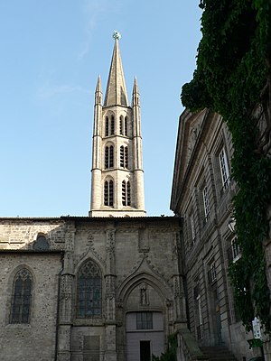
Church of St. Michel des Lions
Roman Catholic church in Haute-Vienne, France
Distance: Approx. 134 meters
Latitude and longitude: 45.83055556,1.25694444
The church of Saint Michel des Lions (French: église Saint-Michel-des-Lions; Limousin Occitan: egleisa de Sent Micheu daus Lions) is one of the main churches in Limoges, Haute-Vienne, France. It derives its name from the two Gallo-Roman stone lions that stand guard at the entrance of the building.

Chapel of St. Aurelianus, Limoges
Roman Catholic chapel in Haute-Vienne, France
Distance: Approx. 366 meters
Latitude and longitude: 45.82833333,1.25722222
The Chapel of St. Aurelianus (French: chapelle Saint-Aurélien; Occitan: chapela de Sant Aurelhan) is a 15th and 17th-century chapel that hosts the relics of Saint Aurelianus in Limoges, Haute-Vienne, France. It is an official Historic Monument.

Musée national Adrien-Dubouché
French national museum
Distance: Approx. 452 meters
Latitude and longitude: 45.832,1.252
Musée national Adrien-Dubouché is a French national museum dedicated to Limoges porcelain and the history of ceramics. Founded in 1845 and located in Limoges (Haute-Vienne), it is part of the Cité de la céramique - Sèvres et Limoges public establishment.
Weather in this IP's area
clear sky
25 Celsius
25 Celsius
25 Celsius
25 Celsius
1020 hPa
73 %
1020 hPa
988 hPa
10000 meters
4.12 m/s
60 degree
06:33:28
21:29:13