Country:
 France
Region:
City:
Latitude and Longitude:
Time Zone:
Postal Code:
IP information under different IP Channel
ip-api
Country
Region
City
ASN
Time Zone
ISP
Blacklist
Proxy
Latitude
Longitude
Postal
Route
IPinfo
Country
Region
City
ASN
Time Zone
ISP
Blacklist
Proxy
Latitude
Longitude
Postal
Route
MaxMind
Country
Region
City
ASN
Time Zone
ISP
Blacklist
Proxy
Latitude
Longitude
Postal
Route
Luminati
Country
FRRegion
ara
City
chamalieres
ASN
Time Zone
Europe/Paris
ISP
ADISTA SAS
Latitude
Longitude
Postal
db-ip
Country
Region
City
ASN
Time Zone
ISP
Blacklist
Proxy
Latitude
Longitude
Postal
Route
ipdata
Country
Region
City
ASN
Time Zone
ISP
Blacklist
Proxy
Latitude
Longitude
Postal
Route
Popular places and events near this IP address

Colmar
City in Grand Est, France
Distance: Approx. 844 meters
Latitude and longitude: 48.0817,7.3556
Colmar (French: Colmar, pronounced [kɔlmaʁ]; Alsatian: Colmer [ˈkolməʁ]; German: Kolmar) is a city and commune in the Haut-Rhin department and Grand Est region of north-eastern France. The third-largest commune in Alsace (after Strasbourg and Mulhouse), it is the seat of the prefecture of the Haut-Rhin department and of the subprefecture of the Colmar-Ribeauvillé arrondissement. The city is renowned for its well-preserved old town, its numerous architectural landmarks and its museums, among which is the Unterlinden Museum, which houses the Isenheim Altarpiece.
Colmar Pocket
WWII German-held area in France
Distance: Approx. 584 meters
Latitude and longitude: 48.08055556,7.36
The Colmar Pocket (French: Poche de Colmar; German: Brückenkopf Elsass) was the area held in central Alsace, France, by the German Nineteenth Army from November 1944 to February 1945, against the U.S. 6th Army Group (6th AG) during World War II. It was formed when 6th AG liberated southern and northern Alsace and adjacent eastern Lorraine, but could not clear central Alsace. During Operation Nordwind in December 1944, the 19th Army attacked north out of the Pocket in support of other German forces attacking south from the Saar into northern Alsace. In late January and early February 1945, the French First Army (reinforced by the U.S. XXI Corps) cleared the Pocket of German forces.
Battle of Argentovaria
Distance: Approx. 848 meters
Latitude and longitude: 48.081667,7.355556
The Battle of Argentovaria or Battle of Argentaria was fought in May 378 between the Western Roman Empire and the invading army of the Lentienses, a branch of the Alemanni, at Argentovaria (near Colmar, France). The Alemanni were overwhelmed by the Roman legionaries, though stood their ground bravely. Only 9,000 escaped from the field and Priarius, king of the Lentienses, was slain during the battle.

Arrondissement of Colmar
Former arrondissement in Grand Est, France
Distance: Approx. 442 meters
Latitude and longitude: 48.08,7.37
The arrondissement of Colmar is a former arrondissement of France in the Haut-Rhin department in the Alsace region. In 2015 it was merged into the new arrondissement of Colmar-Ribeauvillé. It had 62 communes, and its population was 148,444 (2012).
Unterlinden Museum
Art museum, History museum, Design museum in Colmar, France
Distance: Approx. 920 meters
Latitude and longitude: 48.07972222,7.35555556
The Unterlinden Museum (French: Musée Unterlinden) is located in Colmar, in the Alsace region of France. The museum, housed in a 13th-century Dominican religious sisters' convent and a 1906 former public baths building, is home to the Isenheim Altarpiece by the German Renaissance painter Matthias Grünewald and features a large collection of local and international artworks and manufactured artifacts from prehistorical to contemporary times. It is a Musée de France.

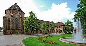
St Martin's Church, Colmar
Church in Colmar, France
Distance: Approx. 919 meters
Latitude and longitude: 48.07722222,7.35833333
The Église Saint-Martin (St. Martin church) is a Roman Catholic church located in Colmar, Haut-Rhin, France. It is in the principal Gothic architectural style.
Embranchement de Colmar
Distance: Approx. 576 meters
Latitude and longitude: 48.0802,7.3729
The Embranchement de Colmar is a canal in eastern France. It connects Colmar to the Rhine at Biesheim. It is 23 km long with three locks.
Bibliothèque municipale de Colmar
Library in Colmar, France
Distance: Approx. 878 meters
Latitude and longitude: 48.0763,7.36126111
The Bibliothèque municipale de Colmar is a library in Colmar, France.

Musée Bartholdi
Art museum in Colmar, France
Distance: Approx. 994 meters
Latitude and longitude: 48.076685,7.357726
The Musée Bartholdi is a museum dedicated to French sculptor Auguste Bartholdi and is situated at 30 rue des Marchands in Colmar, at the artist's birthplace. The museum has the "Musée de France" label. In 2011, the building was labeled "Maisons des Illustres" by the Ministry of Culture and Communication.
Stade des Francs
Football stadium in Colmar, France
Distance: Approx. 154 meters
Latitude and longitude: 48.082,7.366
The Stade des Francs was a football stadium in Colmar, France. It was the home of SR Colmar until 2000.

Ancienne Douane, Colmar
Customs house in Colmar, France
Distance: Approx. 1014 meters
Latitude and longitude: 48.07583333,7.35888889
Ancienne Douane ("Old Custom house"), also known as Koïfhus, is a Gothic and Renaissance building in Colmar, France. It is classified as a monument historique by the French Ministry of Culture since 1930. It is also the birthplace of general Jean Rapp.
Canton of Colmar-1
Distance: Approx. 897 meters
Latitude and longitude: 48.09,7.36
The canton of Colmar-1 is an administrative division of the Haut-Rhin department, northeastern France. It was created at the French canton re-organisation which came into effect on March 2015. Its seat is in Colmar.
Weather in this IP's area
few clouds
21 Celsius
21 Celsius
20 Celsius
24 Celsius
1025 hPa
69 %
1025 hPa
1003 hPa
10000 meters
2.57 m/s
40 degree
20 %
06:01:36
21:12:13