Country:
 France
Region:
City:
Latitude and Longitude:
Time Zone:
Postal Code:
IP information under different IP Channel
ip-api
Country
Region
City
ASN
Time Zone
ISP
Blacklist
Proxy
Latitude
Longitude
Postal
Route
IPinfo
Country
Region
City
ASN
Time Zone
ISP
Blacklist
Proxy
Latitude
Longitude
Postal
Route
MaxMind
Country
Region
City
ASN
Time Zone
ISP
Blacklist
Proxy
Latitude
Longitude
Postal
Route
Luminati
Country
FRRegion
ara
City
chamalieres
ASN
Time Zone
Europe/Paris
ISP
ADISTA SAS
Latitude
Longitude
Postal
db-ip
Country
Region
City
ASN
Time Zone
ISP
Blacklist
Proxy
Latitude
Longitude
Postal
Route
ipdata
Country
Region
City
ASN
Time Zone
ISP
Blacklist
Proxy
Latitude
Longitude
Postal
Route
Popular places and events near this IP address

Vichy
Subprefecture and commune in Auvergne-Rhône-Alpes, France
Distance: Approx. 1457 meters
Latitude and longitude: 46.1278,3.4267
Vichy (, French: [viʃi] ; Occitan: Vichèi [viˈtʃɛj]) is a city in the Allier department in central France. Located on the Allier river, it is a major spa and resort town and during World War II was the capital of Vichy France. As of 2021, Vichy has a population of 25,789.

Arrondissement of Vichy
Arrondissement in Auvergne-Rhône-Alpes, France
Distance: Approx. 1501 meters
Latitude and longitude: 46.12944444,3.42305556
The arrondissement of Vichy is an arrondissement of France in the Allier department in the Auvergne-Rhône-Alpes region. It has 119 communes. Its population is 124,896 (2016), and its area is 2,265.5 km2 (874.7 sq mi).

Abrest
Commune in Auvergne-Rhône-Alpes, France
Distance: Approx. 2929 meters
Latitude and longitude: 46.0994,3.4453
Abrest (French pronunciation: [abʁɛ]; Occitan: Abrèt) is a commune in the Allier department in the Auvergne-Rhône-Alpes region of central France. The commune is one of the 37 communes in the urban area of Vichy and is also part of Vichy Auvergne countryside.

Bellerive-sur-Allier
Commune in Auvergne-Rhône-Alpes, France
Distance: Approx. 953 meters
Latitude and longitude: 46.1175,3.4044
Bellerive-sur-Allier (French pronunciation: [bɛlʁiv syʁ alje]; Occitan: Vaissa) is a commune in the Allier department in central France. Known as Vesse or Vaisse, it was renamed Bellerive-sur-Allier in 1903.
Parc floral et arboré de la Chènevière
Distance: Approx. 2925 meters
Latitude and longitude: 46.09944444,3.44527778
The Parc floral et arboré de la Chènevière is a privately owned park with flower gardens and arboretum located at La Chènevière, 106, route de Quinssat, Abrest, Allier, Auvergne, France. It is open several days per week in the warmer months. The park contains more than 1500 varieties of flowers and trees, set within terraced and themed gardens on the foothills of Bourbonnaise mountain overlooking the Allier valley.

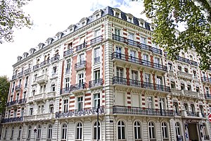
Hôtel du Parc
Distance: Approx. 974 meters
Latitude and longitude: 46.12527778,3.41916667
The Hôtel du Parc (Park Hotel) is a former hotel in the center of Vichy, a spa town in the center of France which hosted during the Second World War the government of the French state (État français), commonly known as Vichy France. The hotel hosted a part of the government offices and the private apartment and offices of the Maréchal Pétain, during the Vichy regime and after 1942 also the offices of Pierre Laval. The building is now a private real estate.

Canton of Bellerive-sur-Allier
Canton in Auvergne-Rhône-Alpes, France
Distance: Approx. 2191 meters
Latitude and longitude: 46.11,3.39
The canton of Bellerive-sur-Allier is an administrative division of the Allier department, in central France. It was created at the French canton reorganisation which came into effect in March 2015. Its seat is in Bellerive-sur-Allier.

Canton of Vichy-1
Canton in Auvergne-Rhône-Alpes, France
Distance: Approx. 1502 meters
Latitude and longitude: 46.13,3.42
The canton of Vichy-1 is an administrative division of the Allier department, in central France. It was created at the French canton reorganisation which came into effect in March 2015. Its seat is in Vichy.

Canton of Vichy-2
Canton in Auvergne-Rhône-Alpes, France
Distance: Approx. 1090 meters
Latitude and longitude: 46.12,3.43
The canton of Vichy-2 is an administrative division of the Allier department, in central France. It was created at the French canton reorganisation which came into effect in March 2015. Its seat is in Vichy.

Aux Marocains
Distance: Approx. 1109 meters
Latitude and longitude: 46.12579,3.42259
Aux Marocains is a confectionery, located 33 rue Clemenceau in the French spa city of Vichy in the Département of Allier, in center of France. Established in 1860, it is still active. Its name come from a candy — Le Marocain (The Marocan) — that was created there in the early 20th century and is still produced, a variant of another candy, the Négus de Nevers.
Hôtel des Ambassadeurs
Hotel in Vichy notable for hosting foreign embassies during World War II
Distance: Approx. 700 meters
Latitude and longitude: 46.1228,3.4189
The Hotel des Ambassadeurs (French for "Ambassadors' Hotel") is a former hotel in Vichy, now transformed into a private residence. During World War II, the hotel housed the diplomatic missions that moved from German-occupied Paris to Vichy.

Saint-Saturnin Church of Cusset
Church in France, France
Distance: Approx. 3557 meters
Latitude and longitude: 46.13194444,3.45722222
The Church of Saint Saturnin in Cusset is a church located in the town center of Cusset, France. It was built between 1857 and 1867 in an early Gothic style, and still functions as the city's main religious building today.
Weather in this IP's area
broken clouds
21 Celsius
21 Celsius
19 Celsius
21 Celsius
1022 hPa
84 %
1022 hPa
993 hPa
10000 meters
1.27 m/s
2.51 m/s
74 degree
83 %
06:23:56
21:21:29