Country:
 France
Region:
City:
Latitude and Longitude:
Time Zone:
Postal Code:
IP information under different IP Channel
ip-api
Country
Region
City
ASN
Time Zone
ISP
Blacklist
Proxy
Latitude
Longitude
Postal
Route
IPinfo
Country
Region
City
ASN
Time Zone
ISP
Blacklist
Proxy
Latitude
Longitude
Postal
Route
MaxMind
Country
Region
City
ASN
Time Zone
ISP
Blacklist
Proxy
Latitude
Longitude
Postal
Route
Luminati
Country
FRRegion
ara
City
chamalieres
ASN
Time Zone
Europe/Paris
ISP
ADISTA SAS
Latitude
Longitude
Postal
db-ip
Country
Region
City
ASN
Time Zone
ISP
Blacklist
Proxy
Latitude
Longitude
Postal
Route
ipdata
Country
Region
City
ASN
Time Zone
ISP
Blacklist
Proxy
Latitude
Longitude
Postal
Route
Popular places and events near this IP address

Bourges
Commune in Centre-Val de Loire, France
Distance: Approx. 299 meters
Latitude and longitude: 47.0844,2.3964
Bourges (French pronunciation: [buʁʒ] ) is a commune in central France on the river Yèvre. It is the capital of the department of Cher, and also was the capital city of the former province of Berry.

Avaricum
Fortified settlement in ancient Gaul
Distance: Approx. 299 meters
Latitude and longitude: 47.0844,2.3964
Avaricum was an oppidum in ancient Gaul, near what is now the city of Bourges. Avaricum, situated in the lands of the Bituriges Cubi, was the largest and best-fortified town within their territory, situated on very fertile lands. The terrain favored the oppidum, as it was flanked by a river and marshland, with only a single narrow entrance.

Bourges Cathedral
Cathedral in Bourges, Cher, France
Distance: Approx. 157 meters
Latitude and longitude: 47.08194444,2.39944444
Bourges Cathedral (French: Cathédrale Saint-Étienne de Bourges) is a Roman Catholic church located in Bourges, France. The cathedral is dedicated to Saint Stephen and is the seat of the Archbishop of Bourges. Built atop an earlier Romanesque church from 1195 until 1230, it is largely in the High Gothic or Classic Gothic architectural style and was constructed at about the same time as Chartres Cathedral.

Arrondissement of Bourges
Arrondissement in Centre-Val de Loire, France
Distance: Approx. 299 meters
Latitude and longitude: 47.0844,2.3964
The arrondissement of Bourges is an arrondissement of France in the Cher department in the Centre-Val de Loire region. It has 128 communes. Its population is 173,037 (2016), and its area is 2,783.9 km2 (1,074.9 sq mi).
Roman Catholic Archdiocese of Bourges
Catholic archdiocese in France
Distance: Approx. 386 meters
Latitude and longitude: 47.08027778,2.3975
The Archdiocese of Bourges (Latin: Archidioecesis Bituricensis; French: Archidiocèse de Bourges) is a Latin Church archdiocese of the Catholic Church in France. The Archdiocese comprises the departements of Cher and Indre in the Region of Val de Loire. Bourges Cathedral stands in the city of Bourges in the department of Cher.

Auron (river)
River in central France
Distance: Approx. 1247 meters
Latitude and longitude: 47.08555556,2.38388889
The Auron (French pronunciation: [oʁɔ̃]) is a 76.9 km (47.8 mi) long river in central France, a left tributary of the river Yèvre. Its source is near the village of Valigny, west of Lurcy-Lévis. The Auron flows generally northwest through the following towns, all in the department of Cher: Bannegon, Dun-sur-Auron, Saint-Just, Plaimpied-Givaudins and Bourges.
Conservatoire national du Pélargonium
Distance: Approx. 3217 meters
Latitude and longitude: 47.0719,2.361
The Conservatoire national du Pélargonium is a municipal botanical garden specializing in pelargoniums, which is located within the municipal greenhouses (serres municipales) on the Chemin Tortiot, Bourges, Cher, Centre-Val de Loire, France. The collection was established in 1986 and now contains 250 pelargonium species and 1,100 cultivars. It describes itself as the largest such collection in France, and has been designated a member of the French Conservatoire des collections végétales spécialisées (CCVS).
Cantons of Bourges
Distance: Approx. 302 meters
Latitude and longitude: 47.08444444,2.39638889
The Cantons of Bourges City are 4 cantons situated in the Cher département and in the Centre-Val de Loire region of France. Each canton covers a part of the commune of Bourges.
Communauté d'agglomération Bourges Plus
Communauté d'agglomération in Centre-Val de Loire, France
Distance: Approx. 302 meters
Latitude and longitude: 47.08444,2.396388
The Communauté d'agglomération Bourges Plus is the communauté d'agglomération, an intercommunal structure, centred on the city of Bourges. It is located in the Cher department, in the Centre-Val de Loire region, central France. It was created 21 October 2002.

Bourges Airport
French airport
Distance: Approx. 3381 meters
Latitude and longitude: 47.06083333,2.37
Bourges Airport (French: Aéroport de Bourges) (IATA: BOU, ICAO: LFLD) is an airport serving Bourges, a commune in the Cher department of the Centre-Val de Loire region of France. It is located 3 km (1.6 NM) southwest of Bourges.
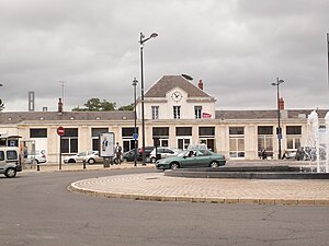
Bourges station
Distance: Approx. 1312 meters
Latitude and longitude: 47.0944,2.3942
Bourges station (French: Gare de Bourges) is a railway station serving the town Bourges, Cher department, central France.

Palais Jacques Coeur
Private mansion in Bourges, France
Distance: Approx. 505 meters
Latitude and longitude: 47.0843,2.3935
The Palais Jacques Cœur is a large hôtel particulier built by Jacques Cœur for himself and his family in Bourges, France. Built and decorated in the flamboyant style, it is widely viewed as one of the most prominent examples of French civilian architecture in the 15th century.
Weather in this IP's area
scattered clouds
19 Celsius
19 Celsius
18 Celsius
20 Celsius
1023 hPa
77 %
1023 hPa
1006 hPa
9000 meters
6.69 m/s
70 degree
45 %
06:24:52
21:28:41