Country:
 France
Region:
City:
Latitude and Longitude:
Time Zone:
Postal Code:
IP information under different IP Channel
ip-api
Country
Region
City
ASN
Time Zone
ISP
Blacklist
Proxy
Latitude
Longitude
Postal
Route
IPinfo
Country
Region
City
ASN
Time Zone
ISP
Blacklist
Proxy
Latitude
Longitude
Postal
Route
MaxMind
Country
Region
City
ASN
Time Zone
ISP
Blacklist
Proxy
Latitude
Longitude
Postal
Route
Luminati
Country
FRRegion
ara
City
chamalieres
ASN
Time Zone
Europe/Paris
ISP
ADISTA SAS
Latitude
Longitude
Postal
db-ip
Country
Region
City
ASN
Time Zone
ISP
Blacklist
Proxy
Latitude
Longitude
Postal
Route
ipdata
Country
Region
City
ASN
Time Zone
ISP
Blacklist
Proxy
Latitude
Longitude
Postal
Route
Popular places and events near this IP address

Verdun
Subprefecture and commune in Grand Est, France
Distance: Approx. 610 meters
Latitude and longitude: 49.162,5.3876
Verdun ( vur-DUN, UK also VAIR-dun, US also vair-DUN, French: [vɛʁdœ̃] ; official name before 1970: Verdun-sur-Meuse) is a city in the Meuse department in Grand Est, northeastern France. It is an arrondissement of the department. Verdun is the biggest city in Meuse, although the capital of the department is Bar-le-Duc, which is slightly smaller than Verdun.
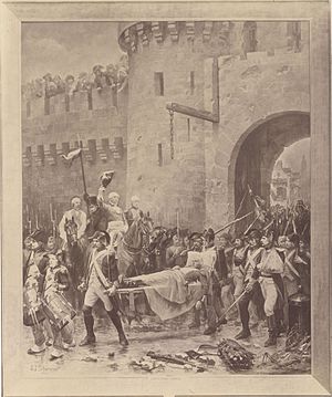
Battle of Verdun (1792)
1792 Battle during the War of the First Coalition
Distance: Approx. 754 meters
Latitude and longitude: 49.1608,5.3884
The first Battle of Verdun was fought between 29 August and 2 September 1792 between French Revolutionary forces and a Prussian army during the opening months of the War of the First Coalition. The Prussians were victorious, gaining a clear westward path to Paris.

Arrondissement of Verdun
Arrondissement in Grand Est, France
Distance: Approx. 1859 meters
Latitude and longitude: 49.15,5.38333333
The arrondissement of Verdun is an arrondissement of France in the Meuse department in the Grand Est region. It has 254 communes. Its population is 85,564 (2016), and its area is 2,828.6 km2 (1,092.1 sq mi).
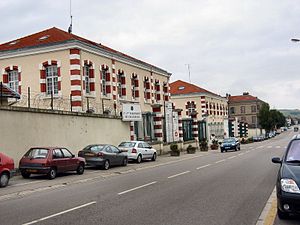
Maginot Barracks
Distance: Approx. 1775 meters
Latitude and longitude: 49.1654,5.359
Maginot Barracks (French: Caserne Maginot) is located in Thierville-sur-Meuse, west of Verdun, France, and has served as a military base for the French and American armies at different times over the past one hundred years.

Verdun Cathedral
Distance: Approx. 811 meters
Latitude and longitude: 49.15944444,5.38222222
Verdun Cathedral (French: Cathédrale Notre-Dame de Verdun) is a Roman Catholic church located in the town of Verdun, Lorraine, France. The cathedral is the seat of the Bishops of Verdun. It was declared a monument historique on 30 October 1906 and the cloister on 13 July 1907.
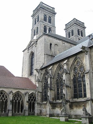
Roman Catholic Diocese of Verdun
Catholic diocese in France
Distance: Approx. 811 meters
Latitude and longitude: 49.15944444,5.38222222
The Diocese of Verdun (Latin: Dioecesis Virodunensis; French: Diocèse de Verdun) is a Latin Church ecclesiastical territory or diocese of the Catholic Church in France. It is a suffragan diocese in the ecclesiastical province of the metropolitan Archdiocese of Besançon. The Diocese of Verdun corresponds to the département of Meuse in the région of Lorraine.
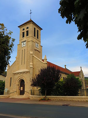
Belleville-sur-Meuse
Commune in Grand Est, France
Distance: Approx. 1147 meters
Latitude and longitude: 49.1769,5.3811
Belleville-sur-Meuse (French pronunciation: [bɛlvil syʁ møz], literally Belleville on Meuse) is a commune in the Meuse department in the Grand Est region in northeastern France.
Canton of Verdun-1
Distance: Approx. 784 meters
Latitude and longitude: 49.16,5.38
The canton of Verdun-1 is an administrative division of the Meuse department, northeastern France. It was created at the French canton reorganization, which came into effect in March 2015. Its seat is in Verdun.
Canton of Verdun-2
Distance: Approx. 1922 meters
Latitude and longitude: 49.15,5.39
The canton of Verdun-2 is an administrative division of the Meuse department, northeastern France. It was created at the French canton reorganisation which came into effect in March 2015. Its seat is in Verdun.
Canton of Belleville-sur-Meuse
Distance: Approx. 1500 meters
Latitude and longitude: 49.18,5.38
The canton of Belleville-sur-Meuse is an administrative division of the Meuse department, northeastern France. It was created at the French canton reorganisation which came into effect in March 2015. Its seat is in Belleville-sur-Meuse.
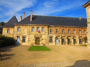
Abbey of St Paul, Verdun
Former monastery in Verdun, France
Distance: Approx. 403 meters
Latitude and longitude: 49.1631,5.3839
The Abbey of St Paul, Verdun (French: L'abbaye Saint-Paul de Verdun), is a former Premonstratensian monastery in Verdun, department of Meuse, Grand Est region, France. The surviving buildings are used for civic purposes. The abbey was founded in 973 by Benedictine monks.
Communauté d'agglomération du Grand Verdun
Communauté d'agglomération in Grand Est, France
Distance: Approx. 2212 meters
Latitude and longitude: 49.18333333,5.36666667
Communauté d'agglomération du Grand Verdun is the communauté d'agglomération, an intercommunal structure, centred on the town of Verdun. It is located in the Meuse department, in the Grand Est region, northeastern France. Created in 2015, its seat is in Verdun.
Weather in this IP's area
few clouds
21 Celsius
21 Celsius
21 Celsius
21 Celsius
1026 hPa
69 %
1026 hPa
1002 hPa
10000 meters
2.67 m/s
3.67 m/s
46 degree
19 %
06:05:41
21:24:00