Country:
 France
Region:
City:
Latitude and Longitude:
Time Zone:
Postal Code:
IP information under different IP Channel
ip-api
Country
Region
City
ASN
Time Zone
ISP
Blacklist
Proxy
Latitude
Longitude
Postal
Route
IPinfo
Country
Region
City
ASN
Time Zone
ISP
Blacklist
Proxy
Latitude
Longitude
Postal
Route
MaxMind
Country
Region
City
ASN
Time Zone
ISP
Blacklist
Proxy
Latitude
Longitude
Postal
Route
Luminati
Country
FRRegion
ara
City
chamalieres
ASN
Time Zone
Europe/Paris
ISP
ADISTA SAS
Latitude
Longitude
Postal
db-ip
Country
Region
City
ASN
Time Zone
ISP
Blacklist
Proxy
Latitude
Longitude
Postal
Route
ipdata
Country
Region
City
ASN
Time Zone
ISP
Blacklist
Proxy
Latitude
Longitude
Postal
Route
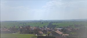
Popular places and events near this IP address
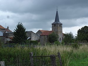
Val-de-Meuse
Commune in Grand Est, France
Distance: Approx. 4188 meters
Latitude and longitude: 48.0003,5.4967
Val-de-Meuse (French pronunciation: [val də møz]) is a commune in the Haute-Marne department in north-eastern France. Val-de-Meuse was created in 1972 by the merger of the former communes of Avrecourt, Épinant, Lécourt, Maulain, Montigny-le-Roi (main area of the new commune), Provenchères-sur-Meuse, Ravennefontaines, Récourt and Saulxures and in 1974 Lénizeul. In 2012 Avrecourt and Saulxures became independent communes again.
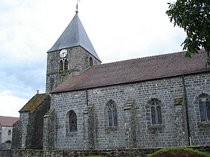
Lavilleneuve
Commune in Grand Est, France
Distance: Approx. 6081 meters
Latitude and longitude: 48.0397,5.5106
Lavilleneuve (French pronunciation: [lavilnœv]) is a commune in the Haute-Marne department in north-eastern France.
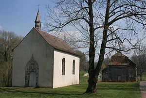
Rançonnières
Commune in Grand Est, France
Distance: Approx. 6215 meters
Latitude and longitude: 47.9369,5.5592
Rançonnières (French pronunciation: [ʁɑ̃sɔnjɛʁ]) is a commune in the Haute-Marne department in north-eastern France.
Bonnecourt
Commune in Grand Est, France
Distance: Approx. 7144 meters
Latitude and longitude: 47.9533,5.4758
Bonnecourt (French pronunciation: [bɔnkuʁ]) is a commune in the Haute-Marne department in northeastern France.

Dammartin-sur-Meuse
Commune in Grand Est, France
Distance: Approx. 2444 meters
Latitude and longitude: 47.9792,5.5778
Dammartin-sur-Meuse (French pronunciation: [damaʁtɛ̃ syʁ møz], literally Dammartin on Meuse) is a commune in the Haute-Marne department in north-eastern France.
Le Châtelet-sur-Meuse
Commune in Grand Est, France
Distance: Approx. 5948 meters
Latitude and longitude: 47.9811,5.6297
Le Châtelet-sur-Meuse (French pronunciation: [lə ʃatlɛ syʁ møz], literally Le Châtelet on Meuse) is a commune in the Haute-Marne department in north-eastern France. It contains the source of the River Meuse, which is very close the commune's village of Pouilly-en-Bassigny.
Choiseul, Haute-Marne
Commune in Grand Est, France
Distance: Approx. 7494 meters
Latitude and longitude: 48.0589,5.5683
Choiseul (French pronunciation: [ʃwazœl]) is a commune in the Haute-Marne department in north-eastern France.
Rangecourt
Commune in Grand Est, France
Distance: Approx. 7563 meters
Latitude and longitude: 48.0442,5.4858
Rangecourt is a commune in the Haute-Marne department in north-eastern France.
Parnoy-en-Bassigny
Commune in Grand Est, France
Distance: Approx. 7177 meters
Latitude and longitude: 48.0078,5.6453
Parnoy-en-Bassigny (French pronunciation: [paʁnwa ɑ̃ basiɲi]) is a commune in the Haute-Marne department in north-eastern France. Parnoy-en-Bassigny was created in 1973 with the merger of Parnot and Fresnoy-en-Bassigny.

Merrey
Commune in Grand Est, France
Distance: Approx. 7599 meters
Latitude and longitude: 48.0553,5.5917
Merrey (French pronunciation: [meʁɛ]) is a commune in the Haute-Marne department in north-eastern France.
Avrecourt
Commune in Grand Est, France
Distance: Approx. 3482 meters
Latitude and longitude: 47.9627,5.5375
Avrecourt (French pronunciation: [avʁəkuʁ]) is a commune in the Haute-Marne department in north-eastern France. Between 1972 and 2012 it was part of the commune Val-de-Meuse.
Saulxures, Haute-Marne
Commune in Grand Est, France
Distance: Approx. 4934 meters
Latitude and longitude: 47.955,5.587
Saulxures is a commune in the Haute-Marne department in north-eastern France. Between 1972 and 2012 it was part of the commune Val-de-Meuse.
Weather in this IP's area
clear sky
22 Celsius
22 Celsius
22 Celsius
22 Celsius
1025 hPa
67 %
1025 hPa
984 hPa
10000 meters
5.36 m/s
7.6 m/s
53 degree
6 %
06:09:11
21:19:10