Country:
 France
Region:
City:
Latitude and Longitude:
Time Zone:
Postal Code:
IP information under different IP Channel
ip-api
Country
Region
City
ASN
Time Zone
ISP
Blacklist
Proxy
Latitude
Longitude
Postal
Route
IPinfo
Country
Region
City
ASN
Time Zone
ISP
Blacklist
Proxy
Latitude
Longitude
Postal
Route
MaxMind
Country
Region
City
ASN
Time Zone
ISP
Blacklist
Proxy
Latitude
Longitude
Postal
Route
Luminati
Country
FRRegion
ara
City
chamalieres
ASN
Time Zone
Europe/Paris
ISP
ADISTA SAS
Latitude
Longitude
Postal
db-ip
Country
Region
City
ASN
Time Zone
ISP
Blacklist
Proxy
Latitude
Longitude
Postal
Route
ipdata
Country
Region
City
ASN
Time Zone
ISP
Blacklist
Proxy
Latitude
Longitude
Postal
Route
Popular places and events near this IP address
Montbéliard
Subprefecture and commune in Bourgogne-Franche-Comté, France
Distance: Approx. 746 meters
Latitude and longitude: 47.51,6.8
Montbéliard (French: [mɔ̃beljaʁ] ; traditional German: Mömpelgard) is a town in the Doubs department in the Bourgogne-Franche-Comté region in eastern France, about 13 km (8 mi) from the border with Switzerland. It is one of the two subprefectures of the department.

Arrondissement of Montbéliard
Arrondissement in Bourgogne-Franche-Comté, France
Distance: Approx. 4 meters
Latitude and longitude: 47.51666667,6.8
The arrondissement of Montbéliard is an arrondissement of France in the Doubs department in the Bourgogne-Franche-Comté region. It has 168 communes. Its population is 176,425 (2016), and its area is 1,255.7 km2 (484.8 sq mi).
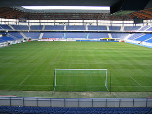
Stade Auguste-Bonal
Stadium in Montbéliard, France
Distance: Approx. 957 meters
Latitude and longitude: 47.5125,6.81111111
Stade Auguste Bonal is a multi-purpose stadium in Montbéliard, France. It is used mostly for football matches. It is the home ground of FC Sochaux-Montbéliard.

Battle of the Lisaine
Distance: Approx. 1859 meters
Latitude and longitude: 47.5,6.8
The Battle of the Lisaine, also known as the Battle of Héricourt, was fought from 15 January to 17 January 1871 between German and French forces. The French were led by Charles Denis Bourbaki, and were attempting to relieve the Siege of Belfort. The Germans prepared XIV Corps and several other divisions, some 40,000–45,000 men, to halt the French advance of about 110,000 men.
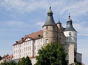
Château de Montbéliard
Distance: Approx. 812 meters
Latitude and longitude: 47.50944444,6.80111111
The Château de Montbéliard (Montbeliard Castle), also known as the Château des ducs de Württemberg (Castle of the Dukes of Württemberg) is a fortress located on an outcropping rock that overlooks the town of Montbéliard in the Doubs département of France. Since 1996, it has been classified as a monument historique by the French Ministry of Culture. The property of the commune, it is open to the public.

Bethoncourt
Commune in Bourgogne-Franche-Comté, France
Distance: Approx. 2100 meters
Latitude and longitude: 47.5353,6.8047
Bethoncourt (French pronunciation: [bətɔ̃kuʁ]) is a commune in the Doubs department in the Bourgogne-Franche-Comté region in eastern France.

Courcelles-lès-Montbéliard
Commune in Bourgogne-Franche-Comté, France
Distance: Approx. 2074 meters
Latitude and longitude: 47.5003,6.7869
Courcelles-lès-Montbéliard (French pronunciation: [kuʁsɛl lɛ mɔ̃beljaʁ], literally Courcelles near Montbéliard) is a commune in the Doubs department in the Bourgogne-Franche-Comté region in eastern France.

Grand-Charmont
Commune in Bourgogne-Franche-Comté, France
Distance: Approx. 2230 meters
Latitude and longitude: 47.5281,6.8244
Grand-Charmont (French pronunciation: [ɡʁɑ̃ ʃaʁmɔ̃]) is a commune in the Doubs department in the Bourgogne-Franche-Comté region in eastern France.

Sainte-Suzanne, Doubs
Commune in Bourgogne-Franche-Comté, France
Distance: Approx. 2285 meters
Latitude and longitude: 47.5069,6.7733
Sainte-Suzanne (French pronunciation: [sɛ̃t syzan]) is a commune in the Doubs department in the Bourgogne-Franche-Comté region in eastern France.

County of Montbéliard
State of the Holy Roman Empire (1042–1793)
Distance: Approx. 720 meters
Latitude and longitude: 47.51027778,6.79888889
The Princely County of Montbéliard (French: Comté princier de Montbéliard; German: Grafschaft Mömpelgard), was a princely county of the Holy Roman Empire seated in the city of Montbéliard in the present-day Franche-Comté region of France. From 1444 onwards it was held by the House of Württemberg. It had full voting rights in the Reichstag.
Stellantis Sochaux Plant
French car manufacturing and assembly plant
Distance: Approx. 1982 meters
Latitude and longitude: 47.509583,6.824167
The Stellantis Sochaux Plant is one of the principal car plants in France - in 2007 approximately 326,000 cars were produced there, and as of May 2011 the staff numbered 11,972 permanent workers, approximately 2,000 temporary workers, as well as over 800 employees from other companies working at the Sochaux plant. The plant was created by Peugeot in 1912, initially as a truck factory, but by the 1930s it had become the company's principal car manufacturing plant, and the main production site for all principal Peugeot models from then until 1972, when the company established a second major French car assembly plant in Mulhouse. In December 2010 the plant produced its 20 millionth car and celebrated by donating the car in question, a Peugeot 5008, to the Haiti Protestant Federation (Fédération protestante d'Haïti), backing the charity's orphan support work in the wake of a major earthquake.
Canton of Montbéliard
Distance: Approx. 746 meters
Latitude and longitude: 47.51,6.8
The canton of Montbéliard is an administrative division of the Doubs department, eastern France. It was created at the French canton reorganisation which came into effect in March 2015. Its seat is in Montbéliard.
Weather in this IP's area
broken clouds
19 Celsius
19 Celsius
18 Celsius
21 Celsius
1024 hPa
77 %
1024 hPa
986 hPa
10000 meters
1.79 m/s
2.2 m/s
46 degree
57 %
06:05:48
21:12:33