Country:
 France
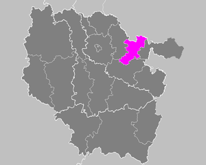
Region:
City:
Latitude and Longitude:
Time Zone:
Postal Code:
IP information under different IP Channel
ip-api
Country
Region
City
ASN
Time Zone
ISP
Blacklist
Proxy
Latitude
Longitude
Postal
Route
IPinfo
Country
Region
City
ASN
Time Zone
ISP
Blacklist
Proxy
Latitude
Longitude
Postal
Route
MaxMind
Country
Region
City
ASN
Time Zone
ISP
Blacklist
Proxy
Latitude
Longitude
Postal
Route
Luminati
Country
FRRegion
ara
City
chamalieres
ASN
Time Zone
Europe/Paris
ISP
ADISTA SAS
Latitude
Longitude
Postal
db-ip
Country
Region
City
ASN
Time Zone
ISP
Blacklist
Proxy
Latitude
Longitude
Postal
Route
ipdata
Country
Region
City
ASN
Time Zone
ISP
Blacklist
Proxy
Latitude
Longitude
Postal
Route
Popular places and events near this IP address
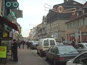
Forbach
Subprefecture and commune in Grand Est, France
Distance: Approx. 746 meters
Latitude and longitude: 49.19,6.9
Forbach ( for-BAHK, French: [fɔʁbak], German: [ˈfɔʁbax]; Alemannic German: Fuerboch) is a commune in the French department of Moselle, northeastern French region of Grand Est. It is located on the German border approximately 15 minutes from the center of Saarbrücken, Germany, with which it constitutes a cross-border conurbation, and is part of the Saar-Moselle Eurodistrict. In 2017, Forbach had a population of 21,552 inhabitants, which, including its greater urban area, makes it the largest town in the eastern Moselle area.
Arrondissement of Forbach
Former arrondissement in Grand Est, France
Distance: Approx. 367 meters
Latitude and longitude: 49.18,6.9
The arrondissement of Forbach is a former arrondissement of France in the Moselle department in the Lorraine region. In 2015 it was merged into the new arrondissement of Forbach-Boulay-Moselle. It had 73 communes, and its population was 167,518 (2012).
Behren-lès-Forbach
Commune in Grand Est, France
Distance: Approx. 2774 meters
Latitude and longitude: 49.1744,6.9356
Behren-lès-Forbach (French pronunciation: [beʁən lɛ fɔʁbak], literally Behren near Forbach; German: Behren) is a commune in the Moselle department in Grand Est in northeastern France. Between 1812 and 1925, it was part of the commune of Kerbach.

Folkling
Commune in Grand Est, France
Distance: Approx. 3967 meters
Latitude and longitude: 49.1478,6.8953
Folkling (French pronunciation: [fɔlklɛ̃]; German: Folklingen; Lorraine Franconian: Folklinge) is a commune in the Moselle department in Grand Est in north-eastern France. Localities of the commune: Gaubiving, Remsing.

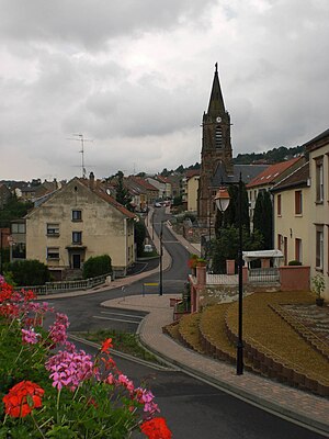
Morsbach, Moselle
Commune in Grand Est, France
Distance: Approx. 2687 meters
Latitude and longitude: 49.1678,6.8717
Morsbach (French pronunciation: [mɔʁsbak]) is a commune in the Moselle department in Grand Est in north-eastern France.
Œting
Commune in Grand Est, France
Distance: Approx. 1507 meters
Latitude and longitude: 49.1744,6.9156
Œting (French pronunciation: [øtɛ̃]; German: Ötingen) is a commune in the Moselle department in Grand Est in north-eastern France.

Stiring-Wendel
Commune in Grand Est, France
Distance: Approx. 2867 meters
Latitude and longitude: 49.2,6.93
Stiring-Wendel (French pronunciation: [stiʁɛ̃ vɑ̃dɛl]; Lorraine Franconian: Stiringe; German Stieringen-Wendel) is a commune in the Moselle department in Grand Est in north-eastern France, wedged between Forbach, Schœneck, Spicheren and Saarbrücken.

Forbach station
French railway station
Distance: Approx. 691 meters
Latitude and longitude: 49.18944444,6.90138889
Forbach railway station (French: Gare de Forbach) is a railway station in Forbach in the Moselle department of north-eastern France. It is the last station in France before the German border at Saarbrücken.

Carreau Wendel Museum
Museum in Moselle, France
Distance: Approx. 4139 meters
Latitude and longitude: 49.2081,6.8576
The Carreau Wendel Museum is the museum of the Wendel-Vuillemin coal pit, in Petite-Rosselle on the Saarland, Lorraine border (Saar-Warndt coal mining basin). Though often in Germany, since 1945 it has been in Moselle department France. The museum is an Anchor point on the European Route of Industrial Heritage.
Canton of Forbach
Distance: Approx. 746 meters
Latitude and longitude: 49.19,6.9
The canton of Forbach is an administrative division of the Moselle department, northeastern France. Its borders were modified at the French canton reorganisation which came into effect in March 2015. Its seat is in Forbach.
Canton of Stiring-Wendel
Distance: Approx. 2867 meters
Latitude and longitude: 49.2,6.93
The canton of Stiring-Wendel is an administrative division of the Moselle department, northeastern France. Its borders were modified at the French canton reorganisation which came into effect in March 2015. Its seat is in Stiring-Wendel.
Communauté d'agglomération de Forbach Porte de France
Communauté d'agglomération in Grand Est, France
Distance: Approx. 2214 meters
Latitude and longitude: 49.16666667,6.91666667
Communauté d'agglomération de Forbach Porte de France is the communauté d'agglomération, an intercommunal structure, centred on the town of Forbach. It is located in the Moselle department, in the Grand Est region, northeastern France. Created in 2003, its seat is in Forbach.
Weather in this IP's area
few clouds
19 Celsius
19 Celsius
18 Celsius
20 Celsius
1025 hPa
75 %
1025 hPa
995 hPa
10000 meters
2.06 m/s
360 degree
20 %
05:59:33
21:18:00