Country:
 France
Region:
City:
Latitude and Longitude:
Time Zone:
Postal Code:
IP information under different IP Channel
ip-api
Country
Region
City
ASN
Time Zone
ISP
Blacklist
Proxy
Latitude
Longitude
Postal
Route
IPinfo
Country
Region
City
ASN
Time Zone
ISP
Blacklist
Proxy
Latitude
Longitude
Postal
Route
MaxMind
Country
Region
City
ASN
Time Zone
ISP
Blacklist
Proxy
Latitude
Longitude
Postal
Route
Luminati
Country
FRRegion
naq
City
floirac
ASN
Time Zone
Europe/Paris
ISP
ADISTA SAS
Latitude
Longitude
Postal
db-ip
Country
Region
City
ASN
Time Zone
ISP
Blacklist
Proxy
Latitude
Longitude
Postal
Route
ipdata
Country
Region
City
ASN
Time Zone
ISP
Blacklist
Proxy
Latitude
Longitude
Postal
Route
Popular places and events near this IP address
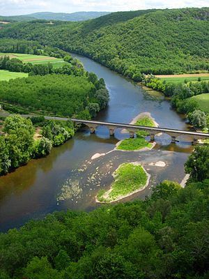
Périgord
Natural region in France
Distance: Approx. 5 meters
Latitude and longitude: 45.18333333,0.71666667
Périgord (UK: PERR-ig-or, US: -OR; French: [peʁiɡɔʁ] ; Occitan: Peiregòrd [pejɾeˈɣɔɾ(t)] or Perigòrd [peɾiˈɣɔɾ(t)]) is a natural region and former province of France, which corresponds roughly to the current Dordogne department, now forming the northern part of the administrative region of Nouvelle-Aquitaine. It is divided into four areas called the Périgord Noir (Black), named so for the truffles that can be found there, the Périgord Blanc (White), for chalk cliffs and quarries, the Périgord Vert (Green), for forests and forestry and the Périgord Pourpre (Purple), for wine and viticulture. The geography and natural resources of Périgord make it a region rich in history and wildlife, and the newly created Parc Naturel Régional Périgord-Limousin aims to conserve it as such.

Arrondissement of Périgueux
Arrondissement in Nouvelle-Aquitaine, France
Distance: Approx. 449 meters
Latitude and longitude: 45.18,0.72
The arrondissement of Périgueux is an arrondissement of France in the Dordogne department in the Nouvelle-Aquitaine region. It has 143 communes. Its population is 175,309 (2016), and its area is 2,869.3 km2 (1,107.8 sq mi).
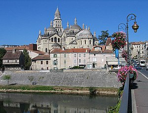
Périgueux Cathedral
Distance: Approx. 478 meters
Latitude and longitude: 45.18361111,0.72277778
Périgueux Cathedral is a Catholic church located in the city of Périgueux, France. A cathedral since 1669, it is dedicated to Saint Front (French: Cathédrale Saint-Front de Périgueux). The cathedral's predecessor, still in operation as a church, is dedicated to Saint Stephen (French: Cathédrale Saint-Étienne-de-la-Cité de Périgueux).

Périgueux station
Railway station in Périgueux, France
Distance: Approx. 877 meters
Latitude and longitude: 45.18777778,0.7075
The Gare de Périgueux is the railway station in the town of Périgueux, in the Dordogne department in France. The station opened in 1857 and is located on the Limoges-Bénédictins - Périgueux and Coutras - Tulle railway lines. The station is served by Intercités (Long distance) and TER (regional) services operated by SNCF, the French national railway.

Plumancy Square
Distance: Approx. 436 meters
Latitude and longitude: 45.1869,0.7145
Plumancy Square (in French: place Plumancy) is a town square, situated in Périgueux (France). It is a traffic circle.

Vesunna Gallo-Roman Museum
Distance: Approx. 488 meters
Latitude and longitude: 45.1799042,0.7127595
The Vesunna Gallo-Roman Museum is a museum of Gallo-Roman art and archaeology in the town of Périgueux, located in the French department of the Dordogne. The Gallo-Roman ruins are covered by a glass display that was constructed to protect a historical monument of France.
Cantons of Périgueux
Division of the town of Périguex, Dordogne, France
Distance: Approx. 790 meters
Latitude and longitude: 45.19,0.72
The cantons of Périgueux are administrative divisions of the Dordogne department, in southwestern France. Since the French canton reorganisation which came into effect in March 2015, the town of Périgueux is subdivided into 2 cantons. Their seat is in Périgueux.
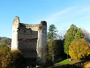
Tower of Vesunna
Gallo-Roman temple vestige
Distance: Approx. 471 meters
Latitude and longitude: 45.179397,0.714397
The Tower of Vesunna is the vestige of a Gallo-Roman fanum (temple) dedicated to Vesunna, a tutelary goddess of the Petrocorii. The sanctuary was built in the 1st or 2nd century. Vesunna was the Gallo-Roman name for Périgueux, in the Dordogne department, in the Nouvelle-Aquitaine region.

Museum of Art and Archeology of Périgord
Art museum in Périgueux, France
Distance: Approx. 623 meters
Latitude and longitude: 45.18598,0.723671
The Museum of Art and Archeology of Périgord, often abbreviated MAAP, is a municipal museum located in Périgueux. It is the oldest museum in the Dordogne department and it includes over 2,000 square metres of permanent exhibition.
Le Grand Périgueux
Communauté d'agglomération in Nouvelle-Aquitaine, France
Distance: Approx. 5 meters
Latitude and longitude: 45.18333333,0.71666667
Le Grand Périgueux is the communauté d'agglomération, an intercommunal structure, centred on the city of Périgueux. It is located in the Dordogne department, in the Nouvelle-Aquitaine region, southwestern France. It was created in January 2014.

Coderc Plaza
Famous plaza located in Périgueux, France.
Distance: Approx. 380 meters
Latitude and longitude: 45.18416667,0.72138889
Coderc Plaza is a town square in Périgueux, in the Dordogne department, France. The square's history dates back to the Middle Ages. Since then, it has been home to the city's most important buildings, including the Maison de la Commune from the Ancien Régime onwards.

Tourny avenues (Périgueux)
Avenues located in the city center of Périgueux.
Distance: Approx. 695 meters
Latitude and longitude: 45.18666667,0.72416667
The Tourny avenues (lit. English for Allées de Tourny) are located in the city center of Périgueux, in the French department of Dordogne. Their history dates back to the 18th century, when Intendant Louis-Urbain Aubert de Tourny created them between 1743 and 1748.
Weather in this IP's area
scattered clouds
27 Celsius
27 Celsius
24 Celsius
27 Celsius
1019 hPa
70 %
1019 hPa
1008 hPa
10000 meters
2.1 m/s
3.02 m/s
71 degree
32 %
06:37:39
21:29:22