Country:
 France
Region:
City:
Latitude and Longitude:
Time Zone:
Postal Code:
IP information under different IP Channel
ip-api
Country
Region
City
ASN
Time Zone
ISP
Blacklist
Proxy
Latitude
Longitude
Postal
Route
IPinfo
Country
Region
City
ASN
Time Zone
ISP
Blacklist
Proxy
Latitude
Longitude
Postal
Route
MaxMind
Country
Region
City
ASN
Time Zone
ISP
Blacklist
Proxy
Latitude
Longitude
Postal
Route
Luminati
Country
FRRegion
naq
City
floirac
ASN
Time Zone
Europe/Paris
ISP
ADISTA SAS
Latitude
Longitude
Postal
db-ip
Country
Region
City
ASN
Time Zone
ISP
Blacklist
Proxy
Latitude
Longitude
Postal
Route
ipdata
Country
Region
City
ASN
Time Zone
ISP
Blacklist
Proxy
Latitude
Longitude
Postal
Route
Popular places and events near this IP address

Saint-Médard-en-Jalles
Commune in Nouvelle-Aquitaine, France
Distance: Approx. 3954 meters
Latitude and longitude: 44.8964,-0.7164
Saint-Médard-en-Jalles (French pronunciation: [sɛ̃ medaʁ ɑ̃ ʒal]; Occitan: Sent Medard de Jalas) is a commune in the Gironde department in Nouvelle-Aquitaine in southwestern France. Located west-northwest of the city of Bordeaux, it is the fifth-largest suburb of the city and a member of the Bordeaux Métropole.

Le Haillan
Commune in Nouvelle-Aquitaine, France
Distance: Approx. 309 meters
Latitude and longitude: 44.8725,-0.6758
Le Haillan (French pronunciation: [lə ajɑ̃]; Occitan: Halhan) is a commune in the Gironde department in south-western France. It is a suburb of the city of Bordeaux, and is adjacent to it on the northwest side.

Eysines
Commune in Nouvelle-Aquitaine, France
Distance: Approx. 2760 meters
Latitude and longitude: 44.8853,-0.65
Eysines (French pronunciation: [ɛzin]; Occitan: Aisinas) is a commune in the Gironde department in southwestern France.

Le Taillan-Médoc
Commune in Nouvelle-Aquitaine, France
Distance: Approx. 3787 meters
Latitude and longitude: 44.9053,-0.6686
Le Taillan-Médoc (French pronunciation: [lə tajɑ̃ medɔk], lit. "The Taillan Médoc"; Occitan: Lo Telhan de Medòc, lit. "The Taillan of Médoc") is a commune in the Gironde department in the Nouvelle-Aquitaine region in Southwestern France.

Château Bel Air (Le Haillan)
Château in France, France
Distance: Approx. 739 meters
Latitude and longitude: 44.874475,-0.670901
Château Bel Air, also called the Château du Haillan, is a château in Le Haillan in the outskirts of Bordeaux, Aquitaine, France. The 1820 building is the administrative headquarters of the FC Girondins de Bordeaux, a football club.

Château Lescombes
Distance: Approx. 2271 meters
Latitude and longitude: 44.88083333,-0.65361111
The Château Lescombes is a château in Eysines, Gironde, Nouvelle-Aquitaine, France. It dates to the 17th century. The dovecote was listed as a monument historique in 1992.
Canton of Saint-Médard-en-Jalles
Distance: Approx. 3105 meters
Latitude and longitude: 44.89,-0.71
The canton of Saint-Médard-en-Jalles is an administrative division of the Gironde department, southwestern France. Its borders were modified at the French canton reorganisation which came into effect in March 2015. Its seat is in Saint-Médard-en-Jalles.
Canton of Les Portes du Médoc
Distance: Approx. 2499 meters
Latitude and longitude: 44.88,-0.65
The canton of Les Portes du Médoc is an administrative division of the Gironde department, southwestern France. It was created at the French canton reorganisation which came into effect in March 2015. Its seat is in Eysines.

Eysines Cantinolle tram stop
Tram station in France
Distance: Approx. 2408 meters
Latitude and longitude: 44.89202,-0.66746694
Eysines Cantinolle tram stop is a stop on the Bordeaux tramway in the commune of Eysines, France. It is the current northwestern terminus of Bordeaux Tramway Line D and opened on 29 February 2020.

Le Haillan Rostand tram stop
Tram stop in Le Haillan, France
Distance: Approx. 1768 meters
Latitude and longitude: 44.85851694,-0.66831889
Le Haillan Rostand tram stop is a tram stop on line A of the Tramway de Bordeaux. It opened on 24 January 2015, when the line was extended from Mérignac Centre and it is the current western terminus of line A. The stop is located just outside the Bordeaux ring road on Avenue de Magudas and in the commune of Le Haillan. It is operated by Transports Bordeaux Métropole.

Les Pins tram stop
Tram stop in Mérignac, France
Distance: Approx. 2311 meters
Latitude and longitude: 44.85695,-0.65982694
Les Pins tram stop is a tram stop on line A of the Tramway de Bordeaux. It opened on 24 January 2015, when the line was extended from Mérignac Centre to Le Haillan Rostand. The stop is located just inside the Bordeaux ring road on Rue Alphonse Daudet and in the commune of Mérignac.
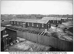
Merignac internment camp
WWII internment camp in Nazi occupied France
Distance: Approx. 3100 meters
Latitude and longitude: 44.84563611,-0.69148333
The Mérignac internment camp, also known as the Beau-Désert internment camp, was a French internment and transit camp for Roma, Jews, French members of the Resistance, and political prisoners; it was located in the district of Beau-Désert in the commune of Mérignac, near Bordeaux, in German occupied France during World War II.
Weather in this IP's area
clear sky
24 Celsius
24 Celsius
22 Celsius
25 Celsius
1019 hPa
70 %
1019 hPa
1015 hPa
10000 meters
4.12 m/s
40 degree
06:44:11
21:34:01