Country:
 France
Region:
City:
Latitude and Longitude:
Time Zone:
Postal Code:
IP information under different IP Channel
ip-api
Country
Region
City
ASN
Time Zone
ISP
Blacklist
Proxy
Latitude
Longitude
Postal
Route
IPinfo
Country
Region
City
ASN
Time Zone
ISP
Blacklist
Proxy
Latitude
Longitude
Postal
Route
MaxMind
Country
Region
City
ASN
Time Zone
ISP
Blacklist
Proxy
Latitude
Longitude
Postal
Route
Luminati
Country
FRRegion
naq
City
floirac
ASN
Time Zone
Europe/Paris
ISP
ADISTA SAS
Latitude
Longitude
Postal
db-ip
Country
Region
City
ASN
Time Zone
ISP
Blacklist
Proxy
Latitude
Longitude
Postal
Route
ipdata
Country
Region
City
ASN
Time Zone
ISP
Blacklist
Proxy
Latitude
Longitude
Postal
Route
Popular places and events near this IP address
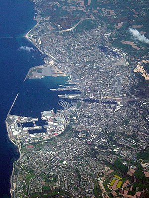
Cherbourg
Former municipality in Manche, France
Distance: Approx. 1749 meters
Latitude and longitude: 49.63,-1.62
Cherbourg is a former commune and subprefecture located at the northern end of the Cotentin peninsula in the northwestern French department of Manche. It was merged into the commune of Cherbourg-Octeville on 28 February 2000, which was merged into the new commune of Cherbourg-en-Cotentin on 1 January 2016. Cherbourg is protected by Cherbourg Harbour, between La Hague and Val de Saire, and the city has been a strategic position over the centuries, disputed between the English and French.

Arrondissement of Cherbourg
Arrondissement in Normandy, France
Distance: Approx. 1649 meters
Latitude and longitude: 49.6375,-1.62888889
The arrondissement of Cherbourg is an arrondissement of France in the Manche department in the Normandy region. It lies entirely on the Cotentin Peninsula and has 144 communes. Its population is 189,748 (2016), and its area is 1,643.9 km2 (634.7 sq mi).
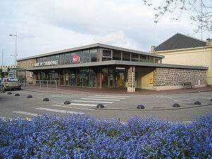
Cherbourg station
Distance: Approx. 1786 meters
Latitude and longitude: 49.63333333,-1.62138889
Gare de Cherbourg is the railway station of the city of Cherbourg, Normandy, France. It is the western terminus of the Mantes-la-Jolie–Cherbourg railway.

Action at Cherbourg (1692)
Distance: Approx. 1749 meters
Latitude and longitude: 49.63,-1.62
The action at Cherbourg was fought on 21 and 22 May Old Style (1st and 2 June New Style) 1692 as part of the aftermath of the Battle of Barfleur which had just been fought on 19 May (Old Style) 1692.

Engineering School of the University of Caen Normandy
Distance: Approx. 870 meters
Latitude and longitude: 49.63388889,-1.64444444
The Engineering School of the University of Caen Normandy (in French: ESIX Normandie, before EIC - École d'Ingénieurs de Cherbourg) is a French engineering university funded in 1993. It is situated in Normandy in two cities: Caen and Cherbourg. The school is accredited by the "Commission des titres d'ingénieur" to deliver Engineering Degrees.

Musée Thomas-Henry
Art museum in France
Distance: Approx. 1925 meters
Latitude and longitude: 49.63722222,-1.62305556
The Musée des beaux-arts Thomas Henry is a museum at Cherbourg-en-Cotentin (Manche) with around 300 artworks, mainly paintings from the 15th to 19th centuries. It has been rated as the third most important collection in Normandy.

Le Trident (theatre)
Distance: Approx. 1975 meters
Latitude and longitude: 49.6378,-1.6229
Le Trident is a group of three theatres in the city of Cherbourg-Octeville, within the Manche department of Normandy, in northern France.
Cherbourg-en-Cotentin
Subprefecture and commune in Normandy, France
Distance: Approx. 1960 meters
Latitude and longitude: 49.639,-1.625
Cherbourg-en-Cotentin (French pronunciation: [ʃɛʁbuʁ ɑ̃ kɔtɑ̃tɛ̃]; Norman: Tchidbouo) is a port city in the department of Manche, Normandy, northwestern France, established on 1 January 2016. The commune takes its name from Cherbourg, the main town of the commune, and the Cotentin Peninsula. Cherbourg is an important commercial, ferry and military port on the English Channel.
Cherbourg-Octeville
Delegated commune in Normandy, France
Distance: Approx. 1749 meters
Latitude and longitude: 49.63,-1.62
Cherbourg-Octeville (French: [ʃɛʁbuʁ ɔkt(ə)vil] ) is a former commune in the Manche department in Normandy in north-western France. It was formed when Cherbourg and Octeville merged on 28 February 2000. On 1 January 2016, it was merged into the new commune of Cherbourg-en-Cotentin, of which it became a delegated commune.
Canton of Cherbourg-en-Cotentin-1
Distance: Approx. 1828 meters
Latitude and longitude: 49.64,-1.63
The canton of Cherbourg-en-Cotentin-1 (before March 2020: canton of Cherbourg-Octeville-1) is an administrative division of the Manche department, northwestern France. It was created at the French canton reorganisation which came into effect in March 2015. Its seat is in Cherbourg-en-Cotentin.
Canton of Cherbourg-en-Cotentin-3
Distance: Approx. 825 meters
Latitude and longitude: 49.62,-1.65
The canton of Cherbourg-en-Cotentin-3 (before March 2020: canton of Cherbourg-Octeville-3) is an administrative division of the Manche department, northwestern France. It was created at the French canton reorganisation which came into effect in March 2015. Its seat is in Cherbourg-en-Cotentin.
Communauté d'agglomération du Cotentin
Communauté d'agglomération in Normandy, France
Distance: Approx. 1828 meters
Latitude and longitude: 49.64,-1.63
Communauté d'agglomération du Cotentin is the communauté d'agglomération, an intercommunal structure, centred on the city of Cherbourg-en-Cotentin, on the Cotentin Peninsula. It is located in the Manche department, in the Normandy region, northwestern France. It was created in January 2017 by the merger of 9 communautés de communes and the 2 new communes Cherbourg-en-Cotentin and La Hague.
Weather in this IP's area
clear sky
16 Celsius
16 Celsius
16 Celsius
16 Celsius
1025 hPa
94 %
1025 hPa
1014 hPa
10000 meters
1.03 m/s
06:32:08
21:53:46