Country:
 France
Region:
City:
Latitude and Longitude:
Time Zone:
Postal Code:
IP information under different IP Channel
ip-api
Country
Region
City
ASN
Time Zone
ISP
Blacklist
Proxy
Latitude
Longitude
Postal
Route
IPinfo
Country
Region
City
ASN
Time Zone
ISP
Blacklist
Proxy
Latitude
Longitude
Postal
Route
MaxMind
Country
Region
City
ASN
Time Zone
ISP
Blacklist
Proxy
Latitude
Longitude
Postal
Route
Luminati
Country
FRRegion
naq
City
floirac
ASN
Time Zone
Europe/Paris
ISP
ADISTA SAS
Latitude
Longitude
Postal
db-ip
Country
Region
City
ASN
Time Zone
ISP
Blacklist
Proxy
Latitude
Longitude
Postal
Route
ipdata
Country
Region
City
ASN
Time Zone
ISP
Blacklist
Proxy
Latitude
Longitude
Postal
Route
Popular places and events near this IP address
University of Caen Normandy
French university
Distance: Approx. 659 meters
Latitude and longitude: 49.1906,-0.3644
The University of Caen Normandy (French: Université de Caen Normandie), also known as Unicaen, is a public university in Caen, France.

Caen
Prefecture and commune in Normandy, France
Distance: Approx. 591 meters
Latitude and longitude: 49.18138889,-0.36361111
Caen (UK: ; French: [kɑ̃] ; Norman: Kaem) is a commune 15 km (9.3 mi) inland from the northwestern coast of France. It is the prefecture of the department of Calvados. The city proper has 105,512 inhabitants (as of 2018), while its functional urban area has 470,000, making Caen the second largest urban area in Normandy and the 19th largest in France.

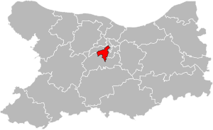
Arrondissement of Caen
Arrondissement in Normandy, France
Distance: Approx. 465 meters
Latitude and longitude: 49.18472222,-0.36527778
The arrondissement of Caen is an arrondissement of France in the Calvados department in the Normandy region. It has 201 communes. Its population is 384,540 (2016), and its area is 1,595.7 km2 (616.1 sq mi).
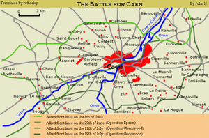
Battle for Caen
Battle during the Normandy campaign
Distance: Approx. 250 meters
Latitude and longitude: 49.18611111,-0.3625
The Battle for Caen (June to August 1944) is the name given to fighting between the British Second Army and the German Panzergruppe West in the Second World War for control of the city of Caen and its vicinity during the larger Battle of Normandy. The battles followed Operation Neptune, the Allied landings on the French coast on 6 June 1944 (D-Day). Caen is about 9 mi (14 km) inland from the Calvados coast astride the Orne River and Caen Canal, at the junction of several roads and railways.

Church of Saint-Pierre, Caen
Church in Caen, France
Distance: Approx. 221 meters
Latitude and longitude: 49.18416667,-0.36083333
The Church of Saint-Pierre (French: Église Saint-Pierre) is a Roman Catholic church located on the Place Saint-Pierre in the centre of Caen in Normandy, northern France. It is dedicated to Saint Peter. Known as Saint-Pierre of Darnetal, Saint-Pierre-sous-Caen, Saint-Pierre-du-Châtel, Saint-Pierre-en-Rive, this church, often mistakenly called by the tourists "the cathedral", as it was the largest religious building of Bourg-le-Roi; special care was therefore given to its development.
Operation Atlantic
Canadian offensive during the Battle of Normandy in the Second World War
Distance: Approx. 615 meters
Latitude and longitude: 49.18333333,-0.36666667
Operation Atlantic (18–21 July 1944) was a Canadian offensive during the Battle of Normandy in the Second World War. The offensive, launched in conjunction with Operation Goodwood by the Second Army, was part of operations to seize the French city of Caen and vicinity from German forces. It was initially successful, with gains made on the flanks of the Orne River near Saint-André-sur-Orne but an attack by the 4th and 6th Canadian Infantry Brigades of the 2nd Canadian Infantry Division, against strongly defended German positions on Verrières Ridge to the south was a costly failure.

Château de Caen
Castle in the Norman city of Caen in France
Distance: Approx. 276 meters
Latitude and longitude: 49.18638889,-0.36277778
The Château de Caen is a castle in the Norman city of Caen in the Calvados département (Normandy). It has been officially classed as a Monument historique since 1997.

Abbey of Sainte-Trinité, Caen
Former nunnery in Caen, Normandy
Distance: Approx. 465 meters
Latitude and longitude: 49.18638889,-0.35277778
The Abbey of Sainte-Trinité (French: Abbaye de la Sainte-Trinité), better known as the Abbaye aux Dames, is a former nunnery in Caen, Normandy, now home to the Regional Council of Normandy. The complex includes the Church of Sainte-Trinité (the Holy Trinity).
Musée des Beaux-Arts de Caen
Art museum in Château de Caen
Distance: Approx. 177 meters
Latitude and longitude: 49.1861004,-0.3614867
The Musée des Beaux-Arts de Caen is a fine arts museum in the French city of Caen, founded at the start of the 19th century and rebuilt in 1971 within the ducal château.
Canton of Caen-5
Canton in Normandy, France
Distance: Approx. 649 meters
Latitude and longitude: 49.18,-0.36
The canton of Caen-5 is an administrative division of the Calvados department, northwestern France. Its borders were modified at the French canton reorganisation which came into effect in March 2015. Its seat is in Caen.

Caen Synagogue
Synagogue in Caen, France
Distance: Approx. 111 meters
Latitude and longitude: 49.1853,-0.36042
The Caen Synagogue (French: Synagogue de Caen), officially Synagogue of the Hebrew Cultural Association, is a Jewish congregation and synagogue, located at 46 Avenue de la Libération, in Caen, Calvados, in the Normandy region of France. The president of the Israelite Cultural Association of Caen (ACI), who own the building, is Nassim Levy.

Normandy Museum
Museum in Caen, France
Distance: Approx. 320 meters
Latitude and longitude: 49.1857,-0.3635
The Normandy Museum (Musée de Normandie) is a public museum in Caen, Normandy, France. It has been housed in the Château de Caen since 1963. In June 1970 the Caen Museum of Fine Arts also moved into the castle, expanding the collection.
Weather in this IP's area
clear sky
20 Celsius
20 Celsius
20 Celsius
21 Celsius
1025 hPa
68 %
1025 hPa
1022 hPa
10000 meters
2.06 m/s
70 degree
06:28:37
21:47:01