Country:
 France
Region:
City:
Latitude and Longitude:
Time Zone:
Postal Code:
IP information under different IP Channel
ip-api
Country
Region
City
ASN
Time Zone
ISP
Blacklist
Proxy
Latitude
Longitude
Postal
Route
IPinfo
Country
Region
City
ASN
Time Zone
ISP
Blacklist
Proxy
Latitude
Longitude
Postal
Route
MaxMind
Country
Region
City
ASN
Time Zone
ISP
Blacklist
Proxy
Latitude
Longitude
Postal
Route
Luminati
Country
FRRegion
naq
City
floirac
ASN
Time Zone
Europe/Paris
ISP
ADISTA SAS
Latitude
Longitude
Postal
db-ip
Country
Region
City
ASN
Time Zone
ISP
Blacklist
Proxy
Latitude
Longitude
Postal
Route
ipdata
Country
Region
City
ASN
Time Zone
ISP
Blacklist
Proxy
Latitude
Longitude
Postal
Route
Popular places and events near this IP address

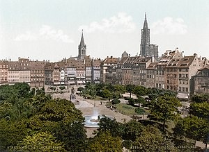
Strasbourg
Prefecture and commune in Grand Est, France
Distance: Approx. 234 meters
Latitude and longitude: 48.58333333,7.74583333
Strasbourg (UK: , US: , French: [stʁasbuʁ] ; German: Straßburg [ˈʃtʁaːsbʊʁk] ;) is the prefecture and largest city of the Grand Est region of eastern France. Located at the border with Germany in the historic region of Alsace, it is the prefecture of the Bas-Rhin department. It is the official seat of the European Parliament.

Petite France, Strasbourg
Quarter in Alsace, France
Distance: Approx. 356 meters
Latitude and longitude: 48.58083333,7.74055556
La Petite France, in Alsatian dialect: Französel (also known as the Quartier des Tanneurs; German: Gerberviertel; "Tanner's Quarter") is the south-western part of the Grande Île of Strasbourg in Alsace in eastern France, the most central and characteristic island of the city that forms the historic center. The district is bounded to the north by the Quai de la Bruche (Brischstade), the Rue du Bain-aux-Plantes, the Place Benjamin-Zix and the Rue des Dentelles; to the east by the Rue du Pont-Saint-Martin, the Pont Saint-Thomas (Thomas Bridge) and the Mills footbridge; to the south by the Channel of Zorn-Mühle; to the west by the Covered Bridges. At Petite France, the river Ill splits up into a number of channels that cascade through an area that was, in the Middle Ages, home to the city's tanners, millers and fishermen, and is now one of Strasbourg's main tourist attractions.

Grande Île, Strasbourg
Island in Strasbourg, France
Distance: Approx. 398 meters
Latitude and longitude: 48.583,7.748
The Grande Île (German: Große Insel) is an island that lies at the historic centre of the city of Strasbourg in France. Its name means "Large Island", and derives from the fact that it is surrounded on one side by the main channel of the Ill river and on the other side by the Canal du Faux-Rempart, a canalised arm of that river. The Grande Île was named a UNESCO World Heritage Site in 1988.
Place Kléber
Distance: Approx. 254 meters
Latitude and longitude: 48.58333333,7.74611111
The Place Kléber (Kleberplatz in German) is the central square of Strasbourg, France. As the largest square at the center of Strasbourg, in the heart of the city's commercial area, it was named after French revolutionary general Jean-Baptiste Kléber, born in Strasbourg in 1753. In the square is a statue of Kléber, under which is a vault containing his remains.

Liberation of Strasbourg
Freeing of Strasbourg, France from German occupation during World War II
Distance: Approx. 233 meters
Latitude and longitude: 48.5833,7.7458
The liberation of Strasbourg took place on 23 November 1944 during the Alsace campaign (November 1944 – March 1945) in the last months of World War II. After the liberation of Mulhouse on 21 November 1944 by the 1st Armored Division, General Philippe Leclerc de Hauteclocque, and the 2nd Armored Division entered the city of Strasbourg in France after having liberated Sarrebourg and La Petite-Pierre from Nazi Germany, which cleared the way to Strasbourg.

Saint-Pierre-le-Jeune Protestant Church
Protestant Church in Strasbourg, France
Distance: Approx. 341 meters
Latitude and longitude: 48.58555556,7.74638889
The Saint-Pierre-le-Jeune Protestant Church (Église protestante Saint-Pierre-le-Jeune) is one of the most important church buildings of the city of Strasbourg, France, from the art historical and architectural viewpoints. It got its name, "Young St. Peter's", because of the existence of three other St.

Strasbourg massacre
1349 public execution of Jews in Strasbourg, France
Distance: Approx. 233 meters
Latitude and longitude: 48.5833,7.7458
The Strasbourg massacre occurred on 14 February 1349, when the entire Jewish community of several thousand Jews were publicly burnt to death as part of the Black Death persecutions. Starting in the spring of 1348, pogroms against Jews had occurred in European cities, starting in Toulon. By November of that year they spread via Savoy to German-speaking territories.

Aubette (building)
Distance: Approx. 222 meters
Latitude and longitude: 48.5839,7.7457
L’Aubette is a historical building on Place Kléber in Strasbourg, France. It was built by Jacques-François Blondel in 1765–1772. In 1926, three avant-garde artists Theo van Doesburg, Sophie Taeuber-Arp and Jean Arp (or Hans Arp) were commissioned by Paul and Adré Horn to redecorate and design the Café Aubette in Strasbourg.
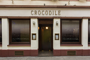
Au Crocodile
Restaurant in Alsace, France
Distance: Approx. 352 meters
Latitude and longitude: 48.583702,7.747483
Au Crocodile is a restaurant in Strasbourg, France, serving French cuisine, holding a Michelin star in 2023.

Old Saint Peter's Church, Strasbourg
Distance: Approx. 224 meters
Latitude and longitude: 48.58277778,7.74
The Church of Old Saint Peters (French: Église Saint-Pierre le Vieux) is a by simultaneum Catholic and Lutheran church building in Strasbourg, Alsace is first mentioned in 1130. In the Middle Ages it was one of Diocese of Strasbourg's nine parish churches. On 22 May 1398 the chapter of the Abbey of Honau, which had been in Rhinau since 1290, moved to Old St Peter's because of flooding in Rhinau.
Jesuit European Social Centre
Belgian research and documentation center
Distance: Approx. 403 meters
Latitude and longitude: 48.58699722,7.74496667
Jesuit European Social Centre (JESC), formerly known as Catholic Office of Information and Initiative for Europe (OCIPE) is a research and documentation center on ethics and European integration founded in 1956.

Synagogue du Quai Kléber
Distance: Approx. 191 meters
Latitude and longitude: 48.58527778,7.74166667
The Synagogue du Quai Kléber (German: Synagoge am Kleberstaden, also formerly known as Neue Synagoge, "New Synagogue") was the main synagogue of Strasbourg, France before World War II. It was built in the "Neustadt" when the city was part of the German Empire (until 1918) and destroyed by Nazi Germany after it annexed the city in 1940; in the years between, Strasbourg and its Jewish community were French.
Weather in this IP's area
few clouds
22 Celsius
22 Celsius
21 Celsius
23 Celsius
1025 hPa
60 %
1025 hPa
1008 hPa
10000 meters
2.57 m/s
360 degree
20 %
05:58:20
21:12:28