Country:
 USA
USARegion:
City:
Latitude and Longitude:
Time Zone:
Postal Code:
IP information under different IP Channel
ip-api
Country
Region
City
ASN
Time Zone
ISP
Blacklist
Proxy
Latitude
Longitude
Postal
Route
IPinfo
Country
Region
City
ASN
Time Zone
ISP
Blacklist
Proxy
Latitude
Longitude
Postal
Route
MaxMind
Country
Region
City
ASN
Time Zone
ISP
Blacklist
Proxy
Latitude
Longitude
Postal
Route
Luminati
Country
 LU
LUASN
Time Zone
Europe/Luxembourg
ISP
Ses Astra S.A.
Latitude
Longitude
Postal
db-ip
Country
Region
City
ASN
Time Zone
ISP
Blacklist
Proxy
Latitude
Longitude
Postal
Route
ipdata
Country
Region
City
ASN
Time Zone
ISP
Blacklist
Proxy
Latitude
Longitude
Postal
Route
Popular places and events near this IP address
Brittany Farms-The Highlands, Pennsylvania
Census-designated place in Pennsylvania, United States
Distance: Approx. 1823 meters
Latitude and longitude: 40.27277778,-75.21555556
Brittany Farms-The Highlands is a census-designated place (CDP) in Bucks County, Pennsylvania, United States. The population was 3,695 at the 2010 census.

Chalfont, Pennsylvania
Home rule municipality in Pennsylvania, United States
Distance: Approx. 178 meters
Latitude and longitude: 40.28972222,-75.21027778
Chalfont is a borough with home rule status in Bucks County, Pennsylvania, United States. The population was 4,009 at the 2010 census. The borough is served by SEPTA Regional Rail's Lansdale/Doylestown Line at Chalfont station.

New Britain station
Distance: Approx. 2674 meters
Latitude and longitude: 40.2972,-75.1798
New Britain station is a SEPTA Regional Rail station in New Britain, Pennsylvania. Located at Tamenend and Matthews Avenues, it serves the Lansdale/Doylestown Line. On December 18, 2011, weekend service was discontinued at this station due to low ridership.

Chalfont station
Distance: Approx. 45 meters
Latitude and longitude: 40.288,-75.209
Chalfont station is a SEPTA Regional Rail station in Chalfont, Pennsylvania. Located at Sunset Avenue and Main Street, it serves the Lansdale/Doylestown Line. In FY 2013, Chalfont station had a weekday average of 136 boardings and 143 alightings.
Chalfont Historic District
Historic district in Pennsylvania, United States
Distance: Approx. 243 meters
Latitude and longitude: 40.29027778,-75.21055556
The Chalfont Historic District is a national historic district located in a portion of the Borough of Chalfont, Bucks County, Pennsylvania. The district encompasses Main Street (Pennsylvania Route 152) and Butler Avenue (U.S. Route 202 Business) with their American colonial and Victorian-style homes. The district includes 121 contributing buildings and 1 contributing site in the borough of Chalfont.
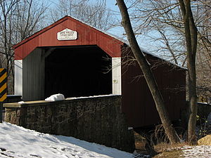
Pine Valley Covered Bridge
United States historic place
Distance: Approx. 2609 meters
Latitude and longitude: 40.30527778,-75.18777778
The Pine Valley Covered Bridge, also known as the Iron Hill Bridge, is an historic, American, wooden covered bridge that is located in New Britain Borough, near Doylestown in Bucks County, Pennsylvania. It crosses Pine Run Creek near Peace Valley Park, and was added to the National Register of Historic Places on December 1, 1980.

Morgan James Homestead
Historic house in Pennsylvania, United States
Distance: Approx. 1998 meters
Latitude and longitude: 40.30527778,-75.20111111
The Morgan James Homestead is an historic, American home that is located in New Britain Township, Bucks County, Pennsylvania. It was added to the National Register of Historic Places in 1977.
Newville, Bucks County, Pennsylvania
Unincorporated community in Pennsylvania, United States
Distance: Approx. 2122 meters
Latitude and longitude: 40.30555556,-75.22
Newville is an unincorporated community in New Britain Township in Bucks County, Pennsylvania, United States. Newville is located at the intersection of Pennsylvania Route 152 and New Galena Road.
Cooks Run (Neshaminy Creek tributary)
River in Pennsylvania, United States
Distance: Approx. 2414 meters
Latitude and longitude: 40.29222222,-75.18111111
Cooks Run is a tributary of the Neshaminy Creek. Rising in Doylestown Township, Bucks County, Pennsylvania, it runs about 2 miles (3.2 km) to its confluence with the Neshaminy Creek.
North Branch Neshaminy Creek
River in Pennsylvania, United States
Distance: Approx. 793 meters
Latitude and longitude: 40.28222222,-75.20444444
North Branch Neshaminy Creek is one of two main branches of the Neshaminy Creek, the other being the West Branch. Rising in Plumstead Township, Bucks County, Pennsylvania, passing through the Peace Valley Park as Lake Galena, then meeting with the West Branch forming the main branch of the Neshaminy.
Pine Run (North Branch Neshaminy Creek tributary)
River in Pennsylvania, United States
Distance: Approx. 493 meters
Latitude and longitude: 40.28888889,-75.20333333
Pine Run is a tributary of the North Branch Neshaminy Creek, part of the Delaware River watershed. Pine Run flows entirely in Bucks County, Pennsylvania, rising in Plumstead Township, passing through Buckingham Township and New Britain Township, meeting its confluence with the North Branch in the Borough of Chalfont.
West Branch Neshaminy Creek
River in Pennsylvania, United States
Distance: Approx. 805 meters
Latitude and longitude: 40.28222222,-75.20416667
West Branch Neshaminy Creek is one of two branches of the Neshaminy Creek, the other being the North Branch, part of the Delaware River watershed. It is located in Bucks and Montgomery Counties in Pennsylvania.
Weather in this IP's area
clear sky
17 Celsius
17 Celsius
15 Celsius
19 Celsius
1020 hPa
87 %
1020 hPa
1012 hPa
10000 meters
05:55:10
20:19:15