Country:
 Nigeria
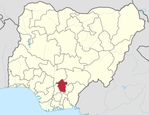
Region:
City:
Latitude and Longitude:
Time Zone:
Postal Code:
IP information under different IP Channel
ip-api
Country
Region
City
ASN
Time Zone
ISP
Blacklist
Proxy
Latitude
Longitude
Postal
Route
IPinfo
Country
Region
City
ASN
Time Zone
ISP
Blacklist
Proxy
Latitude
Longitude
Postal
Route
MaxMind
Country
Region
City
ASN
Time Zone
ISP
Blacklist
Proxy
Latitude
Longitude
Postal
Route
Luminati
Country
 LU
LUASN
Time Zone
Europe/Luxembourg
ISP
Ses Astra S.A.
Latitude
Longitude
Postal
db-ip
Country
Region
City
ASN
Time Zone
ISP
Blacklist
Proxy
Latitude
Longitude
Postal
Route
ipdata
Country
Region
City
ASN
Time Zone
ISP
Blacklist
Proxy
Latitude
Longitude
Postal
Route
Popular places and events near this IP address

Biafra
Partially recognised country in West Africa (1967–1970)
Distance: Approx. 1260 meters
Latitude and longitude: 6.45,7.5
Biafra ( bee-AF-frə), officially the Republic of Biafra, was a partially recognised state in West Africa that declared independence from Nigeria and existed from 1967 until 1970. Its territory consisted of the former Eastern Region of Nigeria, predominantly inhabited by the Igbo ethnic group. Biafra was established on 30 May 1967 by Igbo military officer and Eastern Region governor C. Odumegwu Ojukwu under his presidency, following a series of ethnic tensions and military coups after Nigerian independence in 1960 that culminated in the 1966 anti-Igbo pogrom.

Enugu
Capital city of Enugu state, Nigeria
Distance: Approx. 2328 meters
Latitude and longitude: 6.45277778,7.51111111
Enugu ( ay-NOO-goo; Igbo: Énugwú) is the capital city of Enugu State in Nigeria. It is located inland in the Southeastern part of Nigeria. According to the 2006 census, the city had a population of 820,000.
Enugu State
State of Nigeria
Distance: Approx. 6687 meters
Latitude and longitude: 6.5,7.5
Enugu State (Igbo: Ȯra Enugu) is a state in the South-East geopolitical zone of Nigeria, bordered to the north by the states of Benue and Kogi, Ebonyi State to the east and southeast, Abia State to the south, and Anambra State to the west. The state takes its name from its capital and largest city, Enugu. The city acquired township status in 1917 and was called Enugwu-Ngwo.
Nnamdi Azikiwe Stadium
Sports venue in Enugu, Nigeria
Distance: Approx. 517 meters
Latitude and longitude: 6.4443,7.4965
Nnamdi Azikiwe Stadium is a multi-purpose stadium in Enugu, Nigeria. It is currently used mostly for football matches and is the home stadium of Enugu Rangers. The stadium has a capacity of 22,000 and it was named after the first president of the Republic of Nigeria, Nnamdi Azikiwe.

Akanu Ibiam International Airport
Airport in Nigeria
Distance: Approx. 8287 meters
Latitude and longitude: 6.47388889,7.56111111
Akanu Ibiam International Airport (IATA: ENU, ICAO: DNEN), also known as Enugu Airport, is an airport serving Enugu, the capital city of Enugu State of Nigeria, and nearby cities, such as Abakaliki, Awka, Onitsha, Nnewi, Afikpo, Okigwe, Nsukka, Ugep, Orlu, Idah, Otukpo and Ogoja. The airport was strategically located at Emene, which is the primary Industrial hub in Enugu, It is named after the late Akanu Ibiam (1906–1995), a medical doctor and statesman who hailed from Afikpo in Ebonyi State. The airport was closed on February 10, 2010, by the Federal Airports Authority of Nigeria (FAAN) for the first phase of major renovation and expansion works.

Enugu North
Local Government Area in Enugu State, Nigeria
Distance: Approx. 3847 meters
Latitude and longitude: 6.46666667,7.51666667
Enugu North is a Local Government Area of Enugu State, Nigeria. Its headquarters are in the city of Enugu at Opkara Avenue. The LGA is made up of five main district areas Amaigbo Lane, Onuato, Umunevo, Enugwu-Ngwo and Ihenwuzi.

Enugu South
Local Government Area in Enugu State, Nigeria
Distance: Approx. 4519 meters
Latitude and longitude: 6.4,7.5
Enugu South is a Local Government Area of Enugu State, Nigeria. Its headquarters are in the town of Uwani, Nnobi Street Enugu, and covers the communities of Akwuke, Amechi, Ugwuaji, Obeagu, Awkunanaw and Amechi-Uwani. Enugu South is bounded to the north by Enugu North and to the east by Nkanu East local government areas.
Ekulu River
Distance: Approx. 7811 meters
Latitude and longitude: 6.48333333,7.55
The River Ekulu is a 25-kilometre (16 mi) long river and the largest body of water in the city of Enugu in Enugu State, southeastern Nigeria, and it originates in the same city as well. River Ekulu (River Ekulu) is a stream (class H - Hydrographic) in Nigeria Africa with the region font code of Africa/Middle East. Its coordinates are 6°25'0"N and 7°36'0" E in DMS (Degrees Minutes Seconds) or 6.41667 and 7.6 (in decimal).

Ngwo Pine forest
Pine Forest in Nigeria
Distance: Approx. 5974 meters
Latitude and longitude: 6.4294,7.4414
The Ngwo Pine Forest is a pine forest near the center of Enugu, Nigeria. Within the forest, there is a limestone cave with a small waterfall, forming a shallow pool. The Ngwo Pine Forest is used as a recreational area, supporting the socio-economic development of Enugu State, Nigeria.
Anglican Diocese of Enugu
Chicago illinois
Distance: Approx. 2328 meters
Latitude and longitude: 6.45277778,7.51111111
The Anglican Diocese of Enugu is one of 12 within the Anglican Province of Enugu, itself one of 14 provinces within the Church of Nigeria.
Anglican Diocese of Enugu North
Anglican diocese in Nigeria
Distance: Approx. 3857 meters
Latitude and longitude: 6.47055556,7.51111111
The Anglican Diocese of Enugu North is one of 12 within the Anglican Province of Enugu, itself one of 14 provinces within the Church of Nigeria. The pioneer and current bishop is Sosthenes Eze, appointed in 2007. Eze was consecrated a bishop on March 4, 2007, at the Cathedral of the Advent, Abuja; and the missionary diocese was inaugurated on March 16 at St Mary's Cathedral, Ngwo.
Enugu State Library
Public library in Nigeria
Distance: Approx. 760 meters
Latitude and longitude: 6.43441,7.49066
Enugu State Central Library is a library located along the crowded market in Enugu State. It was founded by UNESCO in 1958 in response to the need for a public library in Nigeria. According to a reporter, Patrick Egwu, who pretended to be a user, the library buildings were damaged with leaky roofs.
Weather in this IP's area
overcast clouds
22 Celsius
23 Celsius
22 Celsius
22 Celsius
1014 hPa
96 %
1014 hPa
991 hPa
10000 meters
2.71 m/s
8.27 m/s
254 degree
100 %
06:24:01
18:48:47