Country:
 Kenya
KenyaRegion:
City:
Latitude and Longitude:
Time Zone:
Postal Code:
IP information under different IP Channel
ip-api
Country
Region
City
ASN
Time Zone
ISP
Blacklist
Proxy
Latitude
Longitude
Postal
Route
IPinfo
Country
Region
City
ASN
Time Zone
ISP
Blacklist
Proxy
Latitude
Longitude
Postal
Route
MaxMind
Country
Region
City
ASN
Time Zone
ISP
Blacklist
Proxy
Latitude
Longitude
Postal
Route
Luminati
Country
 LU
LUASN
Time Zone
Europe/Luxembourg
ISP
Ses Astra S.A.
Latitude
Longitude
Postal
db-ip
Country
Region
City
ASN
Time Zone
ISP
Blacklist
Proxy
Latitude
Longitude
Postal
Route
ipdata
Country
Region
City
ASN
Time Zone
ISP
Blacklist
Proxy
Latitude
Longitude
Postal
Route
Popular places and events near this IP address

2002 Mombasa attacks
Terrorist attacks in Kenya
Distance: Approx. 587 meters
Latitude and longitude: -4.05,39.666
The 2002 Mombasa attacks were a two-pronged terrorist attack on 28 November 2002 in Mombasa, Kenya against an Israeli-owned hotel and a plane belonging to Arkia Airlines. An all-terrain vehicle crashed through a barrier outside the Paradise Hotel and blew up, killing 13 and injuring 80. At the same time, attackers fired two surface-to-air missiles at an Israeli charter plane.

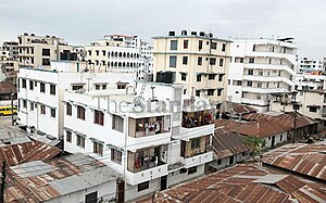
Mombasa
City in Mombasa County, Kenya
Distance: Approx. 624 meters
Latitude and longitude: -4.05,39.66666667
Mombasa ( mom-BASS-ə; also US: -BAH-sə) is a coastal city in southeastern Kenya along the Indian Ocean. It was the first capital of British East Africa, before Nairobi was elevated to capital status in 1907. It now serves as the capital of Mombasa County.
Mombasa Island
Distance: Approx. 624 meters
Latitude and longitude: -4.05,39.66666667
Mombasa Island is a 5 by 3 km (3.1 by 1.9 mi) coral outcrop located on Kenya's coast on the Indian Ocean, which is connected to the mainland by a causeway. Part of the city of Mombasa is located on the island, including the Old Town.
Mombasa County
County in Kenya
Distance: Approx. 624 meters
Latitude and longitude: -4.05,39.66666667
Mombasa County is one of the 47 counties of Kenya. Its capital is Mombasa. In terms of economy it is second after Nairobi.
Mombasa Municipal Stadium
Distance: Approx. 1153 meters
Latitude and longitude: -4.04472222,39.66638889
Municipal Stadium is a multi-purpose stadium in Mombasa, Kenya. It is used mostly for football matches and holds 10,000 people.
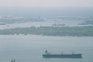
Kilindini Harbour
Port in Kenya
Distance: Approx. 1296 meters
Latitude and longitude: -4.05527778,39.65194444
Kilindini Harbour is a large, natural deep-water inlet extending inland from Mombasa, Kenya. It is 25–30 fathoms (46–55 m) at its deepest center, although the controlling depth is the outer channel in the port approaches with a dredged depth of 17.5 m (57 ft). It serves as the harbour for Mombasa, with a hinterland extending to Uganda.

Moi Avenue (Mombasa)
Distance: Approx. 920 meters
Latitude and longitude: -4.06166667,39.66805556
Moi Avenue is a primary thoroughfare in Mombasa, Kenya. The road runs from west to east from Kilindini to a roundabout with Digo Road. Originally called the Kilindini Road, its name was later changed in recognition of Kenya's second President, Daniel arap Moi.
Majengo, Mombasa
Place in Mombasa County, Kenya
Distance: Approx. 1028 meters
Latitude and longitude: -4.04861111,39.67055556
Majengo is a ward of Mombasa city, Kenya, located on Mombasa Island. It is estimated to have a population of 38,800 in 2011. It is divided between in the Kisauni and Mvita electoral constituencies.
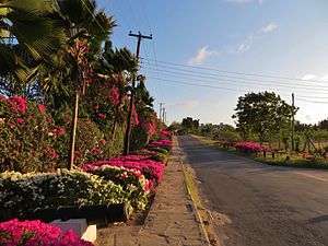
Nyali
Place in Mombasa County, Kenya
Distance: Approx. 645 meters
Latitude and longitude: -4.05,39.667
Nyali is a residential area and Sub-County within Mombasa City, located on the mainland north of Mombasa County. It is connected to Mombasa Island by the New Nyali Bridge. Nyali is known for its many high-class hotels and residential houses, modern standards, and long white sand beaches making it a popular destination for both local and foreign tourists.
MEWA Hospital
Hospital in Mombasa, Kenya
Distance: Approx. 319 meters
Latitude and longitude: -4.052883,39.661377
MEWA Hospital is a hospital in Mombasa, Kenya. It is a project of the Muslim Education and Welfare Association (MEWA) and provides in-patient (with a capacity of 60 beds) and out-patient services operating 24 hours a day.
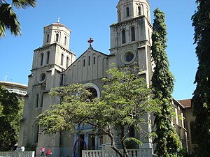
Holy Ghost Cathedral, Mombasa
Church in Mombasa, Kenya
Distance: Approx. 1326 meters
Latitude and longitude: -4.063553,39.671585
The Holy Ghost Cathedral or just Mombasa Cathedral, is the main place of Catholic worship in the city of Mombasa, Kenya, and the seat of the Bishop of the Archdiocese of Mombasa. The first "Catholic mission" of Mombasa was founded in 1889 by Father Alexander le Roy, a Missionary of the Holy Spirit. The residence and the chapel of the first missionaries was in Ndia Kuu (the ancient city of Mombasa), but in 1895 the living conditions had become unbearable, and it was necessary to build a larger building.

Mombasa tusks
Aluminum monument in Mombasa, Kenya
Distance: Approx. 806 meters
Latitude and longitude: -4.0615,39.6661
The Mombasa Tusks, also referred to as Mapembe ya Ndovu or Mapembeni or Pembe za Ndovu (Swahili for elephant tusks), form a monument over Moi Avenue, a major thoroughfare in Mombasa, Kenya. Built in the 1950s to commemorate visits by the British royal family, the monument originally comprised two wooden structures resembling tusks; nowadays, there are four aluminium tusks in an M shape. The monument is under the jurisdiction of the National Museums of Kenya in addition to the city's municipal government.
Weather in this IP's area
few clouds
29 Celsius
31 Celsius
29 Celsius
29 Celsius
1015 hPa
54 %
1015 hPa
1013 hPa
10000 meters
7.2 m/s
160 degree
20 %
06:29:46
18:25:41